Rotorua Caldera
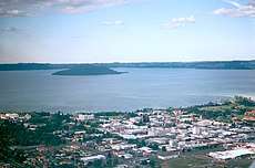
The Rotorua Caldera, a large rhyolitic caldera, is one of several large volcanoes located in the Taupo Volcanic Zone on the North Island of New Zealand. The caldera's last major eruption, about 240,000 years ago, had a Volcanic Explosivity Index of 7. At this time, the Mamaku ignimbrite, covering about 4,000 km2 (1,500 sq mi), was deposited. After the eruption, the magma chamber underneath the volcano collapsed. The circular depression left behind is the current caldera, about 22 km (14 mi) in diameter and now occupied by Lake Rotorua. Mokoia Island, close to the centre of the lake, is a rhyolite dome. There are other domes like Hinemoa Point, Ngongotahā, Pohaturoa and Pukeroa. The most recent magmatic eruption occurred less than 25,000 years ago, creating some of the smaller lava domes.[1] The major regional settlement of Rotorua is located in the caldera. There is geothermal activity in the town of Rotorua.
| Rotorua | |
|---|---|
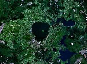 NASA image of Lake Rotorua and caldera | |
| Highest point | |
| Elevation | 757 m (2,484 ft) |
| Coordinates | 38.08°S 176.27°E |
| Geography | |
| Location | North Island, New Zealand |
| Geology | |
| Mountain type | Caldera |
| Volcanic arc/belt | Taupo Volcanic Zone |
| Last eruption | <25,000 years ago[1] |
See also
- Geology of New Zealand
- Geothermal areas in New Zealand
- Geothermal power in New Zealand
- List of volcanoes in New Zealand
- North Island Volcanic Plateau – Volcanic plateau on the North Island of New Zealand
- Taupo Volcanic Zone
- Taupo Volcano
- Volcanology of New Zealand