Rosamond Skypark
Rosamond Skypark (FAA LID: L00) is a residential airpark[2] and public-use airport located three nautical miles (6 km) west of the central business district of Rosamond, in Kern County, California, United States. It is privately owned by the Rosamond Skypark Association.[1]
Rosamond Skypark | |||||||||||
|---|---|---|---|---|---|---|---|---|---|---|---|
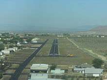 Looking down runway 26. | |||||||||||
| Summary | |||||||||||
| Airport type | Public | ||||||||||
| Owner | Rosamond Skypark Assn. | ||||||||||
| Serves | Rosamond, California | ||||||||||
| Elevation AMSL | 2,415 ft / 736 m | ||||||||||
| Coordinates | 34°52′14″N 118°12′20″W | ||||||||||
| Website | www.skypark.org | ||||||||||
| Runways | |||||||||||
| |||||||||||
| Statistics (2011) | |||||||||||
| |||||||||||
Facilities and aircraft
Rosamond Skypark covers an area of 100 acres (40 ha) at an elevation of 2,415 feet (736 m) above mean sea level. It has one runway designated 8/26 with an asphalt surface measuring 3,600 by 50 feet (1,097 x 15 m).[1]
For the 12-month period ending May 3, 2011, the airport had 15,000 general aviation aircraft operations, an average of 41 per day. At that time there were 71 aircraft based at this airport: 89% single-engine, 4% multi-engine, 1% helicopter, 3% glider, and 3% ultralight.[1] The facility was designed by aeronautical engineer Sam Ramsey who resided at the sleepy airport for years prior to the development. Mr. Ramsey envisioned an airport where pilots could commute to LA while enjoying the quiet High Desert as a residence.
References
- FAA Airport Master Record for L00 (Form 5010 PDF). Federal Aviation Administration. Effective April 5, 2012.
- Rosamond Skypark, official site
External links
- Rosamond Skypark
- Aerial image as of June 1994 from USGS The National Map
- Resources for this airport:
- FAA airport information for L00
- AirNav airport information for L00
- FlightAware airport information and live flight tracker
- SkyVector aeronautical chart for L00