Roosevelt Island, Antarctica
Roosevelt Island is an ice-covered island, about 130 km (81 mi) long in a NW-SE direction, 65 km (40 mi) wide and about 7,500 km2 (2,896 sq mi) in area, lying under the eastern part of the Ross Ice Shelf of Antarctica. Its central ridge rises to about 550 m (1,804 ft) above sea level, but this and all other elevations of the island are completely covered by ice, so that the island is invisible at ground level.
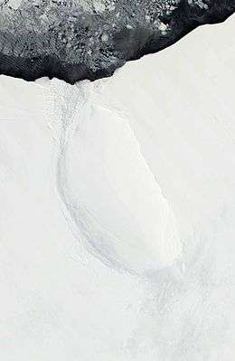 Satellite image of Roosevelt Island | |
 Roosevelt Roosevelt Island | |
| Geography | |
|---|---|
| Location | Antarctica |
| Coordinates | 79°25′S 162°00′W |
| Area | 7,500 km2 (2,900 sq mi) |
| Area rank | 91st |
| Length | 130 km (81 mi) |
| Width | 65 km (40.4 mi) |
| Highest elevation | 550 m (1,800 ft) |
| Administration | |
| Administered under the Antarctic Treaty System | |
| Demographics | |
| Population | Data not available |
| Additional information | |
| Claimed by New Zealand as part of the Ross Dependency. | |
Examination of how the ice flows above it establishes the existence and extent of the island.[1] [2] Rear Admiral Richard E. Byrd named it in 1934 after US President Franklin D. Roosevelt. Byrd was the leader of the expedition that discovered the island.[3]
Roosevelt Island lies within the boundaries of the Ross Dependency, New Zealand's Antarctic claim.
The island has become a focus of the Roosevelt Island Climate Evolution (RICE) research [4] using ice coring.[5]
See also
- Composite Antarctic Gazetteer
- List of Antarctic and sub-Antarctic islands
- List of Antarctic islands south of 60° S
- SCAR
- Territorial claims in Antarctica
References
- Michon Scott (23 April 2007). "Something under the ice is moving". NASA's Earth Observatory. Retrieved 23 September 2010.
- Conway, H.; et al. (1999). "Past and Future Grounding-Line Retreat of the West Antarctic Ice Sheet". Science. 286: 280–283. doi:10.1126/science.286.5438.280.
- Peter Rejcek (3 September 2010). "Roosevelt Island: U.S., Kiwi scientists team up to look at stability of ice shelf". Antarctic Sun. Retrieved 23 September 2010.
- Bertler, N.A.N.; Conway, H.; Dahl-Jensen, D.; Emanuelsson, D.B.; Winstrup, M.; et al. (2018). "The Ross Sea Dipole - Temperature, Snow Accumulation and Sea Ice Variability in the Ross Sea Region, Antarctica, over the Past 2,700 Years". Climate of the Past. 14 (2): 193–214. doi:10.5194/cp-14-193-2018.
-
Talalay, Pavel G. (2016). "9: Cable-Suspended Electromechanical Drills with Bottom-Hole Circulation". Mechanical Ice Drilling Technology. Springer Geophysics. Singapore: Springer. p. 236. ISBN 9789811005602. Retrieved 10 November 2016.
Roosevelt Island is a coastal ice rise [...] where intermediate-depth ice coring was carried out as part of the Roosevelt Island Climate Evolution (RICE) international project led by New Zealand.