Rolling Fork (Arkansas)
Rolling Fork is a 55.4-mile-long (89.2 km)[1] river in southwest Arkansas. It is dammed by DeQueen Dam and forms DeQueen Lake. It is a tributary of the Little River, running parallel with other tributaries such as the Cossatot River, the Saline River, the Mountain Fork, and the Glover River. It is part of the Mississippi watershed.
| Rolling Fork | |
|---|---|
 | |
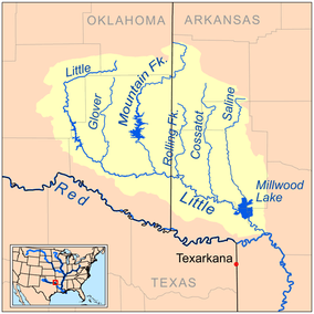 Map of the Little River watershed showing the Rolling Fork | |
| Location | |
| Country | United States |
| State | Arkansas |
| Physical characteristics | |
| Source | Polk County, Arkansas |
| ⁃ coordinates | 34.35150°N 94.34799°W |
| Mouth | Confluence with the Red River in Sevier County, Arkansas |
⁃ coordinates | 33.94067°N 94.3968°W |
| Length | 55.4 mi (89.2 km) |
Location
- Mouth
- Confluence with the Red River in Sevier County, Arkansas 33°56′26″N 94°23′49″W[2]
- Source
- Polk County, Arkansas 34°21′05″N 94°20′53″W[2]
Course
Rolling Fork starts near Hatton, Arkansas. It flows south through Wickes and Grannis. About ten miles from its source Rolling Fork flows into DeQueen Lake, a man-made reservoir. Near Chapel Hill and DeQueen, Arkansas, Rolling Fork exits the lake and continues until it reaches the Little River.
See also
List of Arkansas rivers
References
- "The National Map". U.S. Geological Survey. Retrieved March 8, 2011.
- "Rolling Fork". Geographic Names Information System. United States Geological Survey. Retrieved 2014-01-13.
- Sources
External links
- DeQueen Lake website at the Library of Congress Web Archives (archived 2009-06-18)
This article is issued from Wikipedia. The text is licensed under Creative Commons - Attribution - Sharealike. Additional terms may apply for the media files.