River Cain
The River Cain (Afon Cain in Welsh) is a river in north Powys which flows into the River Vyrnwy.
| River Cain | |
|---|---|
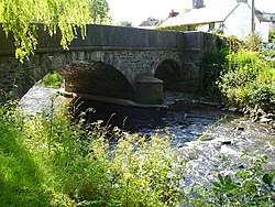 Llanfechain Bridge over Afon Cain | |
 Location of the mouth within Powys | |
| Native name | Afon Cain |
| Location | |
| Country | Wales |
| Counties | Powys |
| Physical characteristics | |
| Source | Confluence of Nant Alan and Nant Fyllon |
| • coordinates | 52.7706°N 3.2837°W |
| Mouth | |
• location | River Vyrnwy |
• coordinates | 52.774°N 3.147°W |
| Length | 16 km (9.9 mi) |
| Basin features | |
| Tributaries | |
| • left | Nant Fyllon, River Abel, Nant Llys |
| • right | Nant Alan, The Brogan |
Cain's source is just west of Llanfyllin, at the confluence of the Nant Alan and Nant Fyllon.[1]
After flowing east through Llanfyllin, where it is joined by the small River Abel, it continues eastwards alongside the A490 highway. It then turns north-east to pass through Llanfechain and is joined by the Nant Llys before finally flowing east again.[2] It is fed by the Brogan,[3] before joining the Vyrnwy near Llansantffraid-ym-Mechain.[4]
The Cain is 16 km long.[5]
 Afon Cain south of Llanfechain
 Afon Cain between Llanfyllin and Llanfechain
References
- "Afon Cain - conf Nant Fyllon to conf The Brogan". Environment Agency - Catchment Data Explorer. Environment Agency. Retrieved 17 March 2016.
- "Subcatchment:Afon Cain - conf The Brogan to conf Afon Vyrnwy". Restoring Europe's Rivers. Environment Agency et al. Retrieved 17 March 2016.
- "The Brogan - source to conf Afon Cain". Environment Agency - Catchment Data Explorer. Environment Agency. Retrieved 17 March 2016.
- "Severn Upper and Cain River". Environment Agency - Catchment Data Explorer. Environment Agency. Retrieved 23 April 2015.
- "Afon Cain". Geoview. Retrieved 19 March 2016.
This article is issued from Wikipedia. The text is licensed under Creative Commons - Attribution - Sharealike. Additional terms may apply for the media files.