Ring's End Local Nature Reserve
Ring's End is an 8.5 hectare Local Nature Reserve which runs south from the hamlet of Ring's End towards March in Cambridgeshire. It is owned and managed by Cambridgeshire County Council.[1][2]
| Ring's End | |
|---|---|
 | |
| |
| Type | Local Nature Reserve |
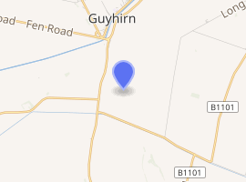
| Location | March, Cambridgeshire |
| OS grid | TF 402 017 |
| Area | 8.5 hectares |
| Managed by | Cambridgeshire County Council |
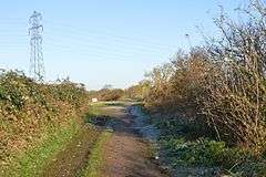
This is a linear site along a disused railway embankment, with views over the Fens. There are also three ponds, reedbeds and areas of scrub.[1] The soil is poor in nutrients, which has allowed uncommon flowering plants such as coltsfoot to become established. Trees include ash and white willow.[3]
The southern end of the site can be accessed from Twenty Foot Road, and National Cycle Route 63 runs through it. There is no access to the northern end.[1]
| Wikimedia Commons has media related to Ring's End. |
References
- "Ring's End". Local Nature Reserves. Natural England. 21 February 2013. Retrieved 20 November 2016.
- "Map of Ring's End". Local Nature Reserves. Natural England. Retrieved 20 November 2016.
- "Local nature reserves : Ring's End". Cambridgeshire County Council. Archived from the original on 23 July 2014. Retrieved 20 November 2016.
This article is issued from Wikipedia. The text is licensed under Creative Commons - Attribution - Sharealike. Additional terms may apply for the media files.