Ring's End
Ring's End is a hamlet near Guyhirn in Cambridgeshire, England. The population is included in the civil parish of Elm.
| Ring's End | |
|---|---|
 Ring's End Location within Cambridgeshire | |
| OS grid reference | TF 39878 02776 |
| Shire county | |
| Region | |
| Country | England |
| Sovereign state | United Kingdom |
| Post town | Wisbech |
| Postcode district | PE13 |
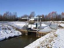
Ring's End Pumping Station
History
Ring's End School was built in 1860 as a school and mission hall. The class rooms were on the upper floor. It was enlarged in 1894-5 and again in 1905. The school was closed in 1949.[1]
In 1889 the 'lock-up'was rented out by Wisbech council.[2]
As a consequence of a bridge being built across the river Nene and the A47 being rerouted, the hamlet now sits on the A141 next to the junction with the A47. Nearby is the Ring's End nature reserve.[3]
References
- ed RB Pugh (1953). A History of Cambridge and the Isle of Ely. OUP.
- "Stamford Mercury". www.britishnewspaperarchive.co.uk. Retrieved 5 October 2019.
- "Ring's End local nature reserve". www.cambridgeshire.gov.uk. Retrieved 9 September 2019.
This article is issued from Wikipedia. The text is licensed under Creative Commons - Attribution - Sharealike. Additional terms may apply for the media files.