Rijeka Crnojevića (river)
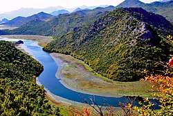
Rijeka Crnojevića (Montenegrin Cyrillic: Ријека Црнојевића), meaning the "River of Crnojević", is the river in Montenegro, emerging just above and running through the eponymous town, close to the northeastern shores of Lake Skadar.
| Rijeka Crnojevića | |
|---|---|
 | |
| Location | |
| Country | Montenegro |
| Physical characteristics | |
| Source | |
| ⁃ coordinates | 42.3520902°N 19.007678°E |
| Mouth | |
⁃ location | Lake Skadar |
⁃ coordinates | 42.3085°N 19.0882°E |
| Length | 12.3 km (7.6 mi) |
| Basin features | |
| Progression | Lake Skadar→ Bojana→ Adriatic Sea |
Its length is 12.3km. The spring of Rijeka Crnojevića is 2.5km south-west from Rijeka Crnojevića town, under the cave in the Obod hill (420m high).[1]
References
- Franetović-Bûre, Dinko (1960). Historija pomorstva i ribarstva Crne Gore do 1918 godine. p. 102.
Dužina telca Rijeke Crnojevića iznosi 12,3 km
| Wikimedia Commons has media related to Rijeka Crnojevića. |
This article is issued from Wikipedia. The text is licensed under Creative Commons - Attribution - Sharealike. Additional terms may apply for the media files.