Remutaka Range
The Remutaka Range (spelled Rimutaka Range before 2017) is the southern-most range of a mountain chain in the lower North Island of New Zealand. The chain continues into the Tararua, then Ruahine Ranges, running parallel with the east coast between Wellington and East Cape.
| Remutaka Range | |
|---|---|
_near_the_top_of_the_range..jpg) State Highway 2 (Rimutaka Hill Road) near the top of the range | |
| Highest point | |
| Elevation | 940 m (3,080 ft) |
| Geography | |
| Location | Wairarapa/Wellington, New Zealand |
The 555-metre summit of the road over the range is named Remutaka Pass. The pass was formally named on 17 December 2015 when the Minister of Land Information confirmed the decision of the New Zealand Geographic Board.[1] Following the passage of the Rangitāne Tū Mai Rā (Wairarapa Tamaki nui-ā-Rua) Claims Settlement Act 2017, the name of the range officially changed to Remutaka Range.[2]
Geography
The Remutaka Range runs north-east to south-west for 55 kilometres from the upper reaches of the Hutt Valley (where they abut the southern end of the Tararuas) to Turakirae Head at the western end of Palliser Bay. The highest peak is Mount Matthews, at 940 metres.
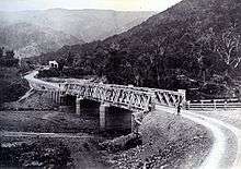
Narrow and winding, State Highway 2 crosses the ridge from the Hutt Valley to Featherston. At the summit is a lookout point where there was a cafe, but after disputes over toilets and land ownership between the Greater Wellington Regional Council and a series of tenants the building sat empty, was severely damaged by fire in April 2009[3][4] and later demolished.
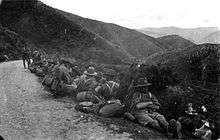
The Wairarapa Line railway used to climb across the Remutakas, including the famous Rimutaka Incline, a rare example of the Fell mountain railway system. It opened on 12 August 1878 and closed on 30 October 1955, when it was replaced by the Rimutaka Tunnel. The former route is now the popular Remutaka Rail Trail and part of the Remutaka Cycle Trail.[5] The Rimutaka Incline Railway Heritage Trust has plans to rebuild the railway from Maymorn, including the Incline, as a tourist and historical attraction.[6]
References
- "Notice of final determinations of the Minister for Land Information on official geographic names". New Zealand Gazette. 17 December 2015. Retrieved 18 March 2018.
- "Place name detail: Remutaka Range". New Zealand Gazetteer. Land Information New Zealand. Retrieved 18 March 2018.
- Don Farmer, Summit a shambles, Wairarapa Times-Age, 2009-03-29, retrieved 2 October 2009.
- "Rimutaka cafe fire treated as arson". Stuff.co.nz. NZPA. 6 April 2009. Retrieved 5 November 2011.
- Churchman & Hurst 2001, p. 154–159.
- Rimutaka Incline Railway Heritage Trust – About Us
Further reading
- Churchman, Geoffrey B; Hurst, Tony (2001) [1990, 1991]. The Railways of New Zealand: A Journey through History (Second ed.). Transpress New Zealand. ISBN 0-908876-20-3.