Red Hill Pass (Colorado)
Red Hill Pass (el. 10,051 ft.[1][2] ) is a high mountain pass in the Rocky Mountains of central Colorado in the United States.
| Red Hill Pass | |
|---|---|
 Red Hill Pass | |
| Elevation | 10,051 ft (3,064 m)[1][2] |
| Traversed by | U.S. Highway 285 |
| Location | Park County, Colorado, United States |
| Range | Mosquito Range |
| Topo map | USGS topo map |
Red Hill Pass Hwy 285
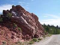
The pass is located in the foothills of the Mosquito Range at the northern end of South Park in Park County. Though unlabeled at the summit, it is identified by signs from both directions at the bottom. True to its name, red hills flank both sides of the summit and the inclines, especially on the south side. It is traversed by U.S. Highway 285 approximately 6 mi (10 km) northeast of the town of Fairplay, The pass is easily traversable by most motor vehicles and rarely closes in the winter.
See also
References
- Scott, Glenn (1999). Historic Trail Map of the Denver 1 ° × 2 ° Quadrangle, Central Colorado. USGS, USDOI. p. 26.
- 1:24,000 scale topo map. USGS. Missing or empty
|title=(help); Missing or empty|url=(help)
This article is issued from Wikipedia. The text is licensed under Creative Commons - Attribution - Sharealike. Additional terms may apply for the media files.