Raritan River
The Raritan River is a major river of central New Jersey in the United States. Its watershed drains much of the mountainous area of the central part of the state, emptying into the Raritan Bay on the Atlantic Ocean.
| Raritan River Rariton | |
|---|---|
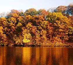 Raritan River as seen from Highland Park | |
 | |
| Etymology | Raritan Indian tribe |
| Location | |
| Country | United States |
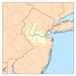
| State | New Jersey |
| Counties | Hunterdon, Mercer, Middlesex, Monmouth, Morris, Somerset |
| Municipalities | Bridgewater Township, Raritan, Somerville, Bound Brook, South Bound Brook, Piscataway, Franklin Township, New Brunswick, Highland Park, Edison, East Brunswick, North Brunswick, Sayreville, Woodbridge, Perth Amboy, South Amboy |
| Physical characteristics | |
| Source | |
| • location | Confluence of South Branch Raritan River and North Branch Raritan River |
| • coordinates | 40°33′20.0″N 74°41′15.6″W |
| • elevation | 47.7 ft (14.5 m) |
| Mouth | |
• location | Raritan Bay |
• coordinates | 40°29′41.4″N 74°16′13.2″W |
• elevation | 0 ft (0 m) |
| Length | 69.6 mi (112.0 km) |
| Basin size | 1,100 sq mi (700,000 acres; 2,800 km2) |
| Width | |
| • average | 200 ft (61 m) |
| Depth | |
| • minimum | 9 ft (2.7 m) |
| • maximum | 25 ft (7.6 m) |
| Discharge | |
| • location | Bound Brook |
| • average | 1,070 cu ft/s (30 m3/s) |
| • minimum | 100 cu ft/s (2.8 m3/s) |
| • maximum | 10,800 cu ft/s (310 m3/s) |
| Basin features | |
| Population | ~1.2 million |
| Tributaries | |
| • left | Peters Brook, Cuckles Brook, Middle Brook, Green Brook, Mill Brook, Red Root Creek, Crows Mill Creek |
| • right | Dukes Brook, Millstone River, Fox Creek, Mile Run, Lawrence Brook, South River |
| Bridges | Victory Bridge, Edison Bridge, Driscoll Bridge, New Jersey Turnpike, U.S. Highway No. 1 Bridge, highway bridge over South River at the town of South River |


Geological history
Geologists assert that the lower Raritan provided the course of the mouth of the Hudson River[1] approximately 6,000 years ago. Following the end of the last ice age, the Narrows had not yet been formed and the Hudson flowed along the Watchung Mountains to present-day Bound Brook, then followed the course of the Raritan eastward into Lower New York Bay.
Description
The river forms at the confluence of the North and South Branches just west of Somerville at the border of Bridgewater, Branchburg, and Hillsborough Townships. It flows for approximately 16 mi (26 km) before slowing in tidewater at New Brunswick, and its estuary extends 14 mi (23 km) more entering the western end of Raritan Bay at South Amboy.
The river has served an important water transportation route since the Pre-Columbian era. The name Raritan is also applied to the Raritan people, an Algonquian tribe that inhabited Staten Island, near the river's mouth. In colonial days, the river allowed the development of early industry around New Brunswick, as well as the transportation of agricultural materials from central New Jersey. During the American Revolutionary War, the river provided a means for troop conveyance. The construction of the Delaware and Raritan Canal along the right (south) bank of the river provided a critical link between New York City and Philadelphia, Pennsylvania on the Delaware River.
Comprehensive measures have been taken to reduce the pollution and increase the water quality. These actions have benefited the fish population which include (but are not limited to) largemouth bass, smallmouth bass, sunfish, catfish, trout, chain pickerel, american eels, carp and yellow perch. Pike can be found in relative abundance in some portions of the river like Clinton and Califon. An occasional Musky has been taken out of the Raritan as well. The tidal portions of the river host migratory salt water species such as striped bass, fluke, winter flounder, weakfish and bluefish. Recently, efforts to restore anadromous fish populations have been made, done by removing many of the obsolete dams and the constructing dam bypass infrastructure. Hopefully this will result in restoring shad, striped bass, and sturgeon populations in the river. Many nesting birds and water fowl make their homes in and along the length of the river. Crustaceans such as blue claw crab, fiddler crabs and green crabs are also found in the tidal sections of the river. Crayfish can be found farther upstream.
The river is also used for recreational boating, including use by the rowing team of Rutgers University in New Brunswick. The river is featured in the title of Rutgers' alma mater, On the Banks of the Old Raritan, and its flooding is mentioned in the song.[2] The musical 1776 mentions troops bathing in the Raritan River.
Near its mouth, the river is spanned by a New Jersey Transit railroad bridge which carries the North Jersey Coast Line; the Victory Bridge which carries Route 35 (connecting Perth Amboy and Sayreville, New Jersey); the Edison Bridge, which carries U.S. Route 9 (connecting Woodbridge Township and Sayreville); and the Driscoll Bridge, which carries the Garden State Parkway (connecting Woodbridge Township and Sayreville).
Water supply
The Raritan River is an important source of drinking water for the central portion of New Jersey. Two water purification plants, operated by New Jersey American Water, are located where the Raritan River and its largest tributary (the Millstone River) meet just east of Manville, New Jersey.
At times of drought and low water flow rates, the flow rate in the Raritan River is enhanced by planned discharges from the Round Valley Reservoir and Spruce Run Reservoir, both of which are located close to the South Branch of the Raritan River in Hunterdon County, New Jersey, and are connected to the river via outflow pipes/channels. The water levels are boosted so downstream water purification facilities will have adequate water supplies in times of drought.
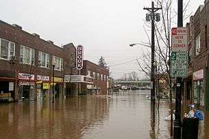
Flooding
The Raritan River has persistent flooding problems when excessive rain from storms affects the river basin. The flooding problems mainly affect the town of Bound Brook, which is partially built on a natural flood plain at the junction of several tributaries, and Manville, which has a large neighborhood known as Lost Valley that lies on the floodplain between the Raritan River and its largest tributary river, which is known as the Millstone River. Other towns in the Raritan River basin also experience flooding to a lesser degree.
Record flooding in the aftermath of Hurricane Floyd in September 1999 (42.13 ft (12.84 m)) flood crest, 14 ft (4.3 m) above flood stage) caused renewed interest in a flood control project called the Green Brook Flood Control Project, which is designed to protect Bound Brook from a 150-year flood. In August 2011, record flooding occurred once again after Hurricane Irene swept through the area. This problem was exacerbated by well-above average rainfall that fell in the weeks before the storm hit, and spurred completion of the Army Corps of Engineers flood control project.[3] As of 2015, the current status of this project is:
- The R2 levee system is functionally complete – The R2 Levee System is designed to provide Bound Brook with protection from a 150-year flood level. The levee is built to the height of the raised Talmage Avenue Bridge.
- Closure gates along Raritan are functionally complete – The gate closures across the New Jersey Transit railroad tracks on the western side of Bound Brook and at the South Main Street railroad underpass that leads to Queens Bridge have been completed and are used to keep flood waters out of Bound Brook.
- The new Talmadge Avenue Bridge that connects Bound Brook and Bridgewater, New Jersey is functionally complete. The replacement bridge was built to the height of the R2 Levee to prevent Middle Brook and Raritan River waters from entering Bound Brook from the west.
- To improve water flow through Bound Brook, the former Conrail bridge over the Raritan River and its associated railroad embankment that were located east of Bound Brook were removed during 2007. The bridge and embankment, when they were in place, acted to block the river flow through the Bound Brook area. To build the main Bound Brook R2 levee, the bridge and embankment needed to be removed.
Communities on the Raritan
(In alphabetical order)
- Bound Brook
- Branchburg
- Bridgewater
- East Brunswick
- Edison
- Franklin Township
- Highland Park
- Hillsborough
- Manville
- Middlesex
- New Brunswick
- Perth Amboy
- Piscataway
- Raritan
- Sayreville
- Somerville
- South Amboy
- South Bound Brook
- Woodbridge
Tributaries
The Raritan river is formed by the confluence of:
Its main tributaries are:
- Green Brook
- Lawrence Brook
- Millstone River
- South River
Others are:
- Arrarat Creek
- Crows Mill Creek
- Cuckholds Brook
- Dukes Brook
- Garron Creek
- Middle Brook
- Mile Run
- Buell Brook
- Mill Brook
- Padilla Creek
- Peters Brook
- Pine Creek
- Randolph Brook
- Red Root Creek
See also
- List of New Jersey rivers
- List of crossings of the Raritan River
- Raritan Bay
- Hudson Canyon
- Sandy Hook Bay
- Arthur Kill
- Delaware and Raritan Canal
- Delaware and Raritan Canal State Park
- Raritan River Project
References
- Steinberg, Ted (2010). Gotham Unbound: The Ecological History of Greater New York. New York: Simon & Schuster. p. 4. ISBN 978-1-476-74124-6.
- A verse of the song goes: "For has she not stood since the time of the flood / On the banks of the old Raritan"
- "Summary of Flooding in New Jersey Caused by Hurricane Irene, August 27–30, 2011". United States Geological Survey. Retrieved November 14, 2015.
External links
| Wikimedia Commons has media related to Raritan River. |