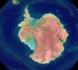
Antarctica
Antarctica (/ænˈtɑːrtɪkə/ or /æntˈɑːrktɪkə/ (![]()
.svg.png) | |
| Area | 14,200,000 km2 (5,500,000 sq mi)[1] |
|---|---|
| Population | 1,000 to 5,000 depending on season |
| Population density | 0.00008 to 0.00040 inhabitants per square kilometre (0.00021 to 0.00104/sq mi) |
| Demonym | Antarctic |
| Countries | 0 |
| Internet TLD | .aq |
| Largest cities | |
| UN M49 code | 010 – Antarctica001 – World |
Antarctica, on average, is the coldest, driest, and windiest continent, and has the highest average elevation of all the continents.[6] Most of Antarctica is a polar desert, with annual precipitation of 200 mm (7.9 in) along the coast and far less inland; there has been no rain there for almost 2 million years, yet 80% of the world freshwater reserves are stored there, enough to raise global sea levels by about 60 metres (200 ft) if all of it were to melt.[7] The temperature in Antarctica has reached −89.2 °C (−128.6 °F) (or even −94.7 °C (−135.8 °F) as measured from space[8]), though the average for the third quarter (the coldest part of the year) is −63 °C (−81 °F). Anywhere from 1,000 to 5,000 people reside throughout the year at research stations scattered across the continent. Organisms native to Antarctica include many types of algae, bacteria, fungi, plants, protista, and certain animals, such as mites, nematodes, penguins, seals and tardigrades. Vegetation, where it occurs, is tundra.
Antarctica is noted as the last region on Earth in recorded history to be discovered, unseen until 1820 when the Russian expedition of Fabian Gottlieb von Bellingshausen and Mikhail Lazarev on Vostok and Mirny sighted the Fimbul ice shelf. The continent, however, remained largely neglected for the rest of the 19th century because of its hostile environment, lack of easily accessible resources, and isolation. In 1895, the first confirmed landing was conducted by a team of Norwegians.
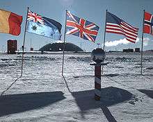
Antarctica is a de facto condominium, governed by parties to the Antarctic Treaty System that have consulting status. Twelve countries signed the Antarctic Treaty in 1959, and thirty-eight have signed it since then. The treaty prohibits military activities and mineral mining, prohibits nuclear explosions and nuclear waste disposal, supports scientific research, and protects the continent's ecology. Ongoing experiments are conducted by more than 4,000 scientists from many nations.
Etymology
The name Antarctica is the romanised version of the Greek compound word ἀνταρκτική (antarktiké), feminine of ἀνταρκτικός (antarktikós),[9] meaning "opposite to the Arctic", "opposite to the north".[10]
Aristotle wrote in his book Meteorology about an Antarctic region in c. 350 BC.[11] Marinus of Tyre reportedly used the name in his unpreserved world map from the 2nd century CE. The Roman authors Hyginus and Apuleius (1–2 centuries CE) used for the South Pole the romanised Greek name polus antarcticus,[12][13] from which derived the Old French pole antartike (modern pôle antarctique) attested in 1270, and from there the Middle English pol antartik in a 1391 technical treatise by Geoffrey Chaucer (modern Antarctic Pole).[14]
Change of name
The long-imagined (but undiscovered) south polar continent was originally called Terra Australis, sometimes shortened to Australia as seen in a woodcut illustration titled "Sphere of the winds", contained in an astrological textbook published in Frankfurt in 1545.[15]
Then in the nineteenth century, the colonial authorities in Sydney removed the Dutch name from New Holland. Instead of inventing a new name to replace it, they took the name Australia from the south polar continent, leaving it nameless for some eighty years. During that period, geographers had to make do with clumsy phrases such as "the Antarctic Continent". They searched for a more poetic replacement, suggesting various names such as Ultima and Antipodea.[16] Eventually Antarctica was adopted as continental name in the 1890s—the first use of the name is attributed to the Scottish cartographer John George Bartholomew.[17]
History of exploration
![]()
.svg.png)
![]()
![]()
![]()
![]()
![]()

Antarctica has no indigenous population. In February 1775, during his second voyage, Captain Cook called the existence of such a polar continent "probable" and in another copy of his journal he wrote: "[I] firmly believe it and it's more than probable that we have seen a part of it".[18]
However, belief in the existence of a Terra Australis—a vast continent in the far south of the globe to "balance" the northern lands of Europe, Asia and North Africa—had prevailed since the times of Ptolemy in the 1st century AD. Even in the late 17th century, after explorers had found that South America and Australia were not part of the fabled "Antarctica", geographers believed that the continent was much larger than its actual size. Integral to the story of the origin of Antarctica's name is that it was not named Terra Australis—this name was given to Australia instead, because of the misconception that no significant landmass could exist further south. Explorer Matthew Flinders, in particular, has been credited with popularising the transfer of the name Terra Australis to Australia. He justified the titling of his book A Voyage to Terra Australis (1814) by writing in the introduction:
There is no probability, that any other detached body of land, of nearly equal extent, will ever be found in a more southern latitude; the name Terra Australis will, therefore, remain descriptive of the geographical importance of this country and of its situation on the globe: it has antiquity to recommend it; and, having no reference to either of the two claiming nations, appears to be less objectionable than any other which could have been selected.[19]
European maps continued to show this hypothetical land until Captain James Cook's ships, HMS Resolution and Adventure, crossed the Antarctic Circle on 17 January 1773, in December 1773 and again in January 1774.[20] Cook came within about 120 km (75 mi) of the Antarctic coast before retreating in the face of field ice in January 1773.[21]
According to various organisations (the National Science Foundation,[22] NASA,[23] the University of California, San Diego,[24] the Russian State Museum of the Arctic and Antarctic,[25] among others),[26][27] ships captained by three men sighted Antarctica or its ice shelf in 1820: Fabian Gottlieb von Bellingshausen (a captain in the Imperial Russian Navy), Edward Bransfield (a captain in the Royal Navy), and Nathaniel Palmer (a sealer from Stonington, Connecticut).
The First Russian Antarctic Expedition led by Bellingshausen and Mikhail Lazarev on the 985-ton sloop-of-war Vostok ("East") and the 530-ton support vessel Mirny ("Peaceful") reached a point within 32 km (20 mi) of Queen Maud's Land and recorded the sight of an ice shelf at 69°21′28″S 2°14′50″W,[28] on 27 January 1820,[29] which became known as the Fimbul ice shelf. This happened three days before Bransfield sighted the land of the Trinity Peninsula of Antarctica, as opposed to the ice of an ice shelf, and ten months before Palmer did so in November 1820. The first documented landing on Antarctica was by the American sealer John Davis, apparently at Hughes Bay, near Cape Charles, in West Antarctica on 7 February 1821, although some historians dispute this claim.[30][31] The first recorded and confirmed landing was at Cape Adair in 1895 (by the Norwegian-Swedish whaling ship Antarctic).[32]
On 22 January 1840, two days after the discovery of the coast west of the Balleny Islands, some members of the crew of the 1837–40 expedition of Jules Dumont d'Urville disembarked on the highest islet[33] of a group of coastal rocky islands about 4 km from Cape Géodésie on the coast of Adélie Land where they took some mineral, algae, and animal samples, erected the French flag and claimed French sovereignty over the territory.[34]
 Discovery and claim of French sovereignty over Adélie Land by Jules Dumont d'Urville, in 1840.
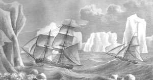 Painting of James Weddell's second expedition in 1823, depicting the brig Jane and the cutter Beaufoy
Explorer James Clark Ross passed through what is now known as the Ross Sea and discovered Ross Island (both of which were named after him) in 1841. He sailed along a huge wall of ice that was later named the Ross Ice Shelf. Mount Erebus and Mount Terror are named after two ships from his expedition: HMS Erebus and Terror.[35] Mercator Cooper landed in East Antarctica on 26 January 1853.[36]
During the Nimrod Expedition led by Ernest Shackleton in 1907, parties led by Edgeworth David became the first to climb Mount Erebus and to reach the South Magnetic Pole. Douglas Mawson, who assumed the leadership of the Magnetic Pole party on their perilous return, went on to lead several expeditions until retiring in 1931.[37] In addition, Shackleton and three other members of his expedition made several firsts in December 1908 – February 1909: they were the first humans to traverse the Ross Ice Shelf, the first to traverse the Transantarctic Mountains (via the Beardmore Glacier), and the first to set foot on the South Polar Plateau. An expedition led by Norwegian polar explorer Roald Amundsen from the ship Fram became the first to reach the geographic South Pole on 14 December 1911, using a route from the Bay of Whales and up the Axel Heiberg Glacier.[38] One month later, the doomed Scott Expedition reached the pole.
Richard E. Byrd led several voyages to the Antarctic by plane in the 1930s and 1940s. He is credited with implementing mechanised land transport on the continent and conducting extensive geological and biological research.[39] The first women to set foot on Antarctica did so in the 1930s with Caroline Mikkelsen landing on an island of Antarctica in 1935,[40] and Ingrid Christensen stepping onto the mainland in 1937.[41][42][43]
It was not until 31 October 1956, that anyone set foot on the South Pole again; on that day a U.S. Navy group led by Rear Admiral George J. Dufek successfully landed an aircraft there.[44] The first women to step onto the South Pole were Pam Young, Jean Pearson, Lois Jones, Eileen McSaveney, Kay Lindsay and Terry Tickhill in 1969.[45]
On 28 November 1979, Air New Zealand Flight 901, a McDonnell Douglas DC-10-30, crashed into Mount Erebus, killing all 257 people on board.[46]
In the southern hemisphere summer of 1996–97 the Norwegian explorer Børge Ousland became the first human to cross Antarctica alone from coast to coast.[47] Ousland got aid from a kite on parts of the distance. All attempted crossings, with no kites or resupplies, that have tried to go from the true continental edges, where the ice meets the sea, have failed due to the great distance that needs to be covered.[48] For this crossing, Ousland also holds the record for the fastest unsupported journey to the South Pole, taking just 34 days.[49]
 Roald Amundsen and his crew looking at the Norwegian flag at the South Pole, 1911
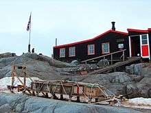
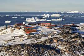 The French Dumont d'Urville Station, an example of modern human settlement in Antarctica
 In 1997 Børge Ousland became the first person to make a solo crossing.
Geography
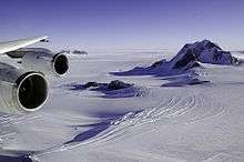
Positioned asymmetrically around the South Pole and largely south of the Antarctic Circle, Antarctica is the southernmost continent and is surrounded by the Southern Ocean; alternatively, it may be considered to be surrounded by the southern Pacific, Atlantic, and Indian Oceans, or by the southern waters of the World Ocean. There are a number of rivers and lakes in Antarctica, the longest river being the Onyx. The largest lake, Vostok, is one of the largest sub-glacial lakes in the world. Antarctica covers more than 14 million km2 (5,400,000 sq mi),[1] making it the fifth-largest continent, about 1.3 times as large as Europe. The coastline measures 17,968 km (11,165 mi)[1] and is mostly characterised by ice formations, as the following table shows:
| Type | Portion |
|---|---|
| Ice shelf (floating ice front) | 44% |
| Ice walls (resting on ground) | 38% |
| Ice stream/outlet glacier (ice front or ice wall) | 13% |
| Rock | 5% |
| Total | 100% |
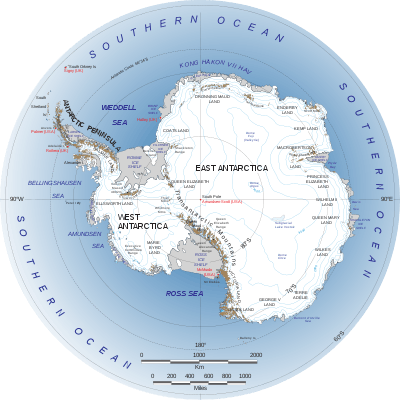
Antarctica is divided in two by the Transantarctic Mountains close to the neck between the Ross Sea and the Weddell Sea. The portion west of the Weddell Sea and east of the Ross Sea is called West Antarctica and the remainder East Antarctica, because they roughly correspond to the Western and Eastern Hemispheres relative to the Greenwich meridian.
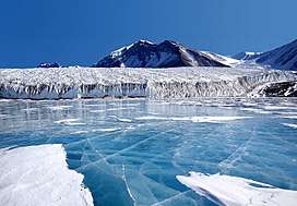
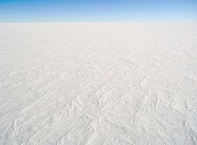
About 98% of Antarctica is covered by the Antarctic ice sheet, a sheet of ice averaging at least 1.6 km (1.0 mi) thick. The continent has about 90% of the world's ice (and thus about 70% of the world's fresh water). If all of this ice were melted, sea levels would rise about 60 m (200 ft).[51] In most of the interior of the continent, precipitation is very low, down to 20 mm (0.8 in) per year; in a few "blue ice" areas precipitation is lower than mass loss by sublimation, and so the local mass balance is negative. In the dry valleys, the same effect occurs over a rock base, leading to a desiccated landscape.
West Antarctica is covered by the West Antarctic Ice Sheet. The sheet has been of recent concern because of the small possibility of its collapse. If the sheet were to break down, ocean levels would rise by several metres in a relatively geologically short period of time, perhaps a matter of centuries. Several Antarctic ice streams, which account for about 10% of the ice sheet, flow to one of the many Antarctic ice shelves: see ice-sheet dynamics.
East Antarctica lies on the Indian Ocean side of the Transantarctic Mountains and comprises Coats Land, Queen Maud Land, Enderby Land, Mac. Robertson Land, Wilkes Land, and Victoria Land. All but a small portion of this region lies within the Eastern Hemisphere. East Antarctica is largely covered by the East Antarctic Ice Sheet.
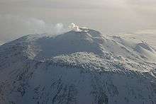
Vinson Massif, the highest peak in Antarctica at 4,892 m (16,050 ft), is located in the Ellsworth Mountains. Antarctica contains many other mountains, on both the main continent and the surrounding islands. Mount Erebus on Ross Island is the world's southernmost active volcano. Another well-known volcano is found on Deception Island, which is famous for a giant eruption in 1970. Minor eruptions are frequent, and lava flow has been observed in recent years. Other dormant volcanoes may potentially be active.[52] In 2004, a potentially active underwater volcano was found in the Antarctic Peninsula by American and Canadian researchers.[53]
Antarctica is home to more than 70 lakes that lie at the base of the continental ice sheet. Lake Vostok, discovered beneath Russia's Vostok Station in 1996, is the largest of these subglacial lakes. It was once believed that the lake had been sealed off for 500,000 to one million years, but a recent survey suggests that, every so often, there are large flows of water from one lake to another.[54]
There is some evidence, in the form of ice cores drilled to about 400 m (1,300 ft) above the water line, that Lake Vostok's waters may contain microbial life. The frozen surface of the lake shares similarities with Jupiter's moon, Europa. If life is discovered in Lake Vostok, it would strengthen the argument for the possibility of life on Europa.[55][56] On 7 February 2008, a NASA team embarked on a mission to Lake Untersee, searching for extremophiles in its highly alkaline waters. If found, these resilient creatures could further bolster the argument for extraterrestrial life in extremely cold, methane-rich environments.[57]
In September 2018, researchers at the National Geospatial-Intelligence Agency released a high resolution terrain map (detail down to the size of a car, and less in some areas) of Antarctica, named the "Reference Elevation Model of Antarctica" (REMA).[58]
Geology


Geological history and palaeontology
More than 170 million years ago, Antarctica was part of the supercontinent Gondwana. Over time, Gondwana gradually broke apart, and Antarctica as we know it today was formed around 25 million years ago. Antarctica was not always cold, dry, and covered in ice sheets. At a number of points in its long history, it was farther north, experienced a tropical or temperate climate, was covered in forests,[59] and inhabited by various ancient life forms.
Palaeozoic era (540–250 Ma)
During the Cambrian period, Gondwana had a mild climate. West Antarctica was partially in the Northern Hemisphere, and during this period large amounts of sandstones, limestones and shales were deposited. East Antarctica was at the equator, where sea floor invertebrates and trilobites flourished in the tropical seas. By the start of the Devonian period (416 Ma), Gondwana was in more southern latitudes and the climate was cooler, though fossils of land plants are known from this time. Sand and silts were laid down in what is now the Ellsworth, Horlick and Pensacola Mountains. Glaciation began at the end of the Devonian period (360 Ma), as Gondwana became centred on the South Pole and the climate cooled, though flora remained. During the Permian period, the land became dominated by seed plants such as Glossopteris, a pteridosperm which grew in swamps. Over time these swamps became deposits of coal in the Transantarctic Mountains. Towards the end of the Permian period, continued warming led to a dry, hot climate over much of Gondwana.[60]
Mesozoic era (250–66 Ma)
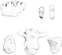
As a result of continued warming, the polar ice caps melted and much of Gondwana became a desert. In Eastern Antarctica, seed ferns or pteridosperms became abundant and large amounts of sandstone and shale were laid down at this time. Synapsids, commonly known as "mammal-like reptiles", were common in Antarctica during the Early Triassic and included forms such as Lystrosaurus. The Antarctic Peninsula began to form during the Jurassic period (206–146 Ma), and islands gradually rose out of the ocean. Ginkgo trees, conifers, bennettites, horsetails, ferns and cycads were plentiful during this period. In West Antarctica, coniferous forests dominated through the entire Cretaceous period (146–66 Ma), though southern beech became more prominent towards the end of this period. Ammonites were common in the seas around Antarctica, and dinosaurs were also present, though only three Antarctic dinosaur genera (Cryolophosaurus and Glacialisaurus, from the Hanson Formation,[61] and Antarctopelta) have been described to date.[62] It was during this era that Gondwana began to break up.
However, there is some evidence of antarctic marine glaciation during the Cretaceous period.[63]
Gondwana breakup (160–23 Ma)
The cooling of Antarctica occurred stepwise, as the continental spread changed the oceanic currents from longitudinal equator-to-pole temperature-equalising currents to latitudinal currents that preserved and accentuated latitude temperature differences.
Africa separated from Antarctica in the Jurassic, around 160 Ma, followed by the Indian subcontinent in the early Cretaceous (about 125 Ma). By the end of the Cretaceous, about 66 Ma, Antarctica (then connected to Australia) still had a subtropical climate and flora, complete with a marsupial fauna.[64] In the Eocene epoch, about 40 Ma Australia-New Guinea separated from Antarctica, so that latitudinal currents could isolate Antarctica from Australia, and the first ice began to appear. During the Eocene–Oligocene extinction event about 34 million years ago, CO2 levels have been found to be about 760 ppm[65] and had been decreasing from earlier levels in the thousands of ppm.
Around 23 Ma, the Drake Passage opened between Antarctica and South America, resulting in the Antarctic Circumpolar Current that completely isolated the continent. Models of the changes suggest that declining CO2 levels became more important.[66] The ice began to spread, replacing the forests that until then had covered the continent. Since about 15 Ma, the continent has been mostly covered with ice.[67]
Meyer Desert Formation biota
Fossil Nothofagus leaves in the Meyer Desert Formation of the Sirius Group show that intermittent warm periods allowed Nothofagus shrubs to cling to the Dominion Range as late as 3–4 Ma (mid-late Pliocene).[68] After that, the Pleistocene ice age covered the whole continent and destroyed all major plant life on it.[69]
Present-day
The geological study of Antarctica has been greatly hindered by nearly all of the continent being permanently covered with a thick layer of ice.[70] However, new techniques such as remote sensing, ground-penetrating radar and satellite imagery have begun to reveal the structures beneath the ice.
Geologically, West Antarctica closely resembles the Andes mountain range of South America.[60] The Antarctic Peninsula was formed by uplift and metamorphism of sea bed sediments during the late Paleozoic and the early Mesozoic eras. This sediment uplift was accompanied by igneous intrusions and volcanism. The most common rocks in West Antarctica are andesite and rhyolite volcanics formed during the Jurassic period. There is also evidence of volcanic activity, even after the ice sheet had formed, in Marie Byrd Land and Alexander Island. The only anomalous area of West Antarctica is the Ellsworth Mountains region, where the stratigraphy is more similar to East Antarctica.
East Antarctica is geologically varied, dating from the Precambrian era, with some rocks formed more than 3 billion years ago. It is composed of a metamorphic and igneous platform which is the basis of the continental shield. On top of this base are coal and various modern rocks, such as sandstones, limestones and shales laid down during the Devonian and Jurassic periods to form the Transantarctic Mountains. In coastal areas such as Shackleton Range and Victoria Land some faulting has occurred.
The main mineral resource known on the continent is coal.[67] It was first recorded near the Beardmore Glacier by Frank Wild on the Nimrod Expedition, and now low-grade coal is known across many parts of the Transantarctic Mountains. The Prince Charles Mountains contain significant deposits of iron ore. The most valuable resources of Antarctica lie offshore, namely the oil and natural gas fields found in the Ross Sea in 1973. Exploitation of all mineral resources is banned until 2048 by the Protocol on Environmental Protection to the Antarctic Treaty.
Climate
Antarctica is the coldest of Earth's continents. It used to be ice-free until about 34 million years ago, when it became covered with ice.[71] The lowest natural air temperature ever recorded on Earth was −89.2 °C (−128.6 °F) at the Russian Vostok Station in Antarctica on 21 July 1983.[72] For comparison, this is 10.7 °C (20 °F) colder than subliming dry ice at one atmosphere of partial pressure, but since CO2 only makes up 0.039% of air, temperatures of less than −140 °C (−220 °F)[73] would be needed to produce dry ice snow in Antarctica. A lower air temperature of −94.7 °C (−138.5 °F) was recorded in 2010 by satellite—however, it may be influenced by ground temperatures and was not recorded at a height of 7 feet (2 m) above the surface as required for the official air temperature records.[74] Antarctica is a frozen desert with little precipitation; the South Pole receives less than 10 mm (0.4 in) per year, on average. Temperatures reach a minimum of between −80 °C (−112 °F) and −89.2 °C (−128.6 °F) in the interior in winter and reach a maximum of between 5 °C (41 °F) and 15 °C (59 °F) near the coast in summer. Northern Antarctica recorded a temperature of 20.75 °C (69.3 °F) on 9 February 2020, the highest recorded temperature in the continent.[75][76] Sunburn is often a health issue as the snow surface reflects almost all of the ultraviolet light falling on it. Given the latitude, long periods of constant darkness or constant sunlight create climates unfamiliar to human beings in much of the rest of the world.[77]
East Antarctica is colder than its western counterpart because of its higher elevation. Weather fronts rarely penetrate far into the continent, leaving the centre cold and dry. Despite the lack of precipitation over the central portion of the continent, ice there lasts for extended periods. Heavy snowfalls are common on the coastal portion of the continent, where snowfalls of up to 1.22 metres (48 in) in 48 hours have been recorded.
At the edge of the continent, strong katabatic winds off the polar plateau often blow at storm force. In the interior, wind speeds are typically moderate. During clear days in summer, more solar radiation reaches the surface at the South Pole than at the equator because of the 24 hours of sunlight each day at the Pole.[1]
Antarctica is colder than the Arctic for three reasons. First, much of the continent is more than 3,000 m (9,800 ft) above sea level, and temperature decreases with elevation in the troposphere. Second, the Arctic Ocean covers the north polar zone: the ocean's relative warmth is transferred through the icepack and prevents temperatures in the Arctic regions from reaching the extremes typical of the land surface of Antarctica. Third, the Earth is at aphelion in July (i.e., the Earth is farthest from the Sun in the Antarctic winter), and the Earth is at perihelion in January (i.e., the Earth is closest to the Sun in the Antarctic summer). The orbital distance contributes to a colder Antarctic winter (and a warmer Antarctic summer) but the first two effects have more impact.[78]
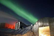
The aurora australis, commonly known as the southern lights, is a glow observed in the night sky near the South Pole created by the plasma-full solar winds that pass by the Earth. Another unique spectacle is diamond dust, a ground-level cloud composed of tiny ice crystals. It generally forms under otherwise clear or nearly clear skies, so people sometimes also refer to it as clear-sky precipitation. A sun dog, a frequent atmospheric optical phenomenon, is a bright "spot" beside the true sun.[77]
Population
Several governments maintain permanent manned research stations on the continent. The number of people conducting and supporting scientific research and other work on the continent and its nearby islands varies from about 1,000 in winter to about 5,000 in the summer, giving it a population density between 70 and 350 inhabitants per million square kilometres (180 and 900 per million square miles) at these times. Many of the stations are staffed year-round, the winter-over personnel typically arriving from their home countries for a one-year assignment. An Orthodox church—Trinity Church, opened in 2004 at the Russian Bellingshausen Station—is manned year-round by one or two priests, who are similarly rotated every year.[79][80]
The first semi-permanent inhabitants of regions near Antarctica (areas situated south of the Antarctic Convergence) were British and American sealers who used to spend a year or more on South Georgia, from 1786 onward. During the whaling era, which lasted until 1966, the population of that island varied from over 1,000 in the summer (over 2,000 in some years) to some 200 in the winter. Most of the whalers were Norwegian, with an increasing proportion of Britons. The settlements included Grytviken, Leith Harbour, King Edward Point, Stromness, Husvik, Prince Olav Harbour, Ocean Harbour and Godthul. Managers and other senior officers of the whaling stations often lived together with their families. Among them was the founder of Grytviken, Captain Carl Anton Larsen, a prominent Norwegian whaler and explorer who, along with his family, adopted British citizenship in 1910.
The first child born in the southern polar region was Norwegian girl Solveig Gunbjørg Jacobsen, born in Grytviken on 8 October 1913, and her birth was registered by the resident British Magistrate of South Georgia. She was a daughter of Fridthjof Jacobsen, the assistant manager of the whaling station, and Klara Olette Jacobsen. Jacobsen arrived on the island in 1904 and became the manager of Grytviken, serving from 1914 to 1921; two of his children were born on the island.[81]
Emilio Marcos Palma was the first person born south of the 60th parallel south as well as the first born on the Antarctic mainland, in 1978 at Esperanza Base, on the tip of the Antarctic Peninsula;[82][83] his parents were sent there along with seven other families by the Argentine government to determine if the continent was suitable for family life. In 1984, Juan Pablo Camacho was born at the Frei Montalva Station, becoming the first Chilean born in Antarctica. Several bases are now home to families with children attending schools at the station.[84] As of 2009, eleven children were born in Antarctica (south of the 60th parallel south): eight at the Argentine Esperanza Base[85] and three at the Chilean Frei Montalva Station.[86]
Biodiversity
The terrestrial and native all year round species appears to be the descendants of ancestors who lived in geothermally warmed environments during the last ice age, when these areas were the only places on the continent not covered by ice.[87]
Animals
Few terrestrial vertebrates live in Antarctica, and those that do are limited to the sub-Antarctic islands.[88] Invertebrate life includes microscopic mites like the Alaskozetes antarcticus, lice, nematodes, tardigrades, rotifers, krill and springtails. The flightless midge Belgica antarctica, up to 6 mm (1⁄4 in) in size, is the largest purely terrestrial animal in Antarctica.[89] Another member of Chironomidae is Parochlus steinenii.[90] The snow petrel is one of only three birds that breed exclusively in Antarctica.[91]
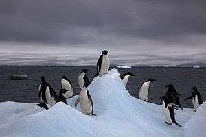
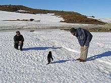
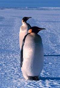
Some species of marine animals exist and rely, directly or indirectly, on the phytoplankton. Antarctic sea life includes penguins, blue whales, orcas, colossal squids and fur seals. The emperor penguin is the only penguin that breeds during the winter in Antarctica, while the Adélie penguin breeds farther south than any other penguin. The southern rockhopper penguin has distinctive feathers around the eyes, giving the appearance of elaborate eyelashes. King penguins, chinstrap penguins, and gentoo penguins also breed in the Antarctic.
The Antarctic fur seal was very heavily hunted in the 18th and 19th centuries for its pelt by sealers from the United States and the United Kingdom. The Weddell seal, a "true seal", is named after Sir James Weddell, commander of British sealing expeditions in the Weddell Sea. Antarctic krill, which congregate in large schools, is the keystone species of the ecosystem of the Southern Ocean, and is an important food organism for whales, seals, leopard seals, fur seals, squid, icefish, penguins, albatrosses and many other birds.[92]
A census of sea life carried out during the International Polar Year and which involved some 500 researchers was released in 2010. The research is part of the global Census of Marine Life and has disclosed some remarkable findings. More than 235 marine organisms live in both polar regions, having bridged the gap of 12,000 km (7,456 mi). Large animals such as some cetaceans and birds make the round trip annually. More surprising are small forms of life such as sea cucumbers and free-swimming snails found in both polar oceans. Various factors may aid in their distribution – fairly uniform temperatures of the deep ocean at the poles and the equator which differ by no more than 5 °C, and the major current systems or marine conveyor belt which transport eggs and larval stages.[93]
Fungi
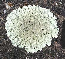
About 1,150 species of fungi have been recorded from Antarctica, of which about 750 are non-lichen-forming and 400 are lichen-forming.[94][95] Some of these species are cryptoendoliths as a result of evolution under extreme conditions, and have significantly contributed to shaping the impressive rock formations of the McMurdo Dry Valleys and surrounding mountain ridges. The apparently simple morphology, scarcely differentiated structures, metabolic systems and enzymes still active at very low temperatures, and reduced life cycles shown by such fungi make them particularly suited to harsh environments such as the McMurdo Dry Valleys. In particular, their thick-walled and strongly melanised cells make them resistant to UV light. Those features can also be observed in algae and cyanobacteria, suggesting that these are adaptations to the conditions prevailing in Antarctica. This has led to speculation that, if life ever occurred on Mars, it might have looked similar to Antarctic fungi such as Cryomyces antarcticus, and Cryomyces minteri.[96] Some of these fungi are also apparently endemic to Antarctica. Endemic Antarctic fungi also include certain dung-inhabiting species which have had to evolve in response to the double challenge of extreme cold while growing on dung, and the need to survive passage through the gut of warm-blooded animals.[97]
Plants
About 298 million years ago Permian forests started to cover the continent, and tundra vegetation survived as late as 15 million years ago,[98] but the climate of present-day Antarctica does not allow extensive vegetation to form. A combination of freezing temperatures, poor soil quality, lack of moisture, and lack of sunlight inhibit plant growth. As a result, the diversity of plant life is very low and limited in distribution. The flora of the continent largely consists of bryophytes. There are about 100 species of mosses and 25 species of liverworts, but only three species of flowering plants, all of which are found in the Antarctic Peninsula: Deschampsia antarctica (Antarctic hair grass), Colobanthus quitensis (Antarctic pearlwort) and the non-native Poa annua (annual bluegrass).[99] Growth is restricted to a few weeks in the summer.[94][100]
Other organisms
Seven hundred species of algae exist, most of which are phytoplankton. Multicoloured snow algae and diatoms are especially abundant in the coastal regions during the summer.[100] Bacteria have been found living in the cold and dark as deep as 800 m (0.50 mi; 2,600 ft) under the ice.[101]
Conservation
The Protocol on Environmental Protection to the Antarctic Treaty (also known as the Environmental Protocol or Madrid Protocol) came into force in 1998, and is the main instrument concerned with conservation and management of biodiversity in Antarctica. The Antarctic Treaty Consultative Meeting is advised on environmental and conservation issues in Antarctica by the Committee for Environmental Protection. A major concern within this committee is the risk to Antarctica from unintentional introduction of non-native species from outside the region.[102]
The passing of the Antarctic Conservation Act (1978) in the U.S. brought several restrictions to U.S. activity on Antarctica. The introduction of alien plants or animals can bring a criminal penalty, as can the extraction of any indigenous species. The overfishing of krill, which plays a large role in the Antarctic ecosystem, led officials to enact regulations on fishing. The Convention for the Conservation of Antarctic Marine Living Resources (CCAMLR), a treaty that came into force in 1980, requires that regulations managing all Southern Ocean fisheries consider potential effects on the entire Antarctic ecosystem.[1] Despite these new acts, unregulated and illegal fishing, particularly of Patagonian toothfish (marketed as Chilean Sea Bass in the U.S.), remains a serious problem. The illegal fishing of toothfish has been increasing, with estimates of 32,000 tonnes (35,000 short tons) in 2000.[103][104]
Politics
Several countries claim sovereignty in certain regions. While a few of these countries have mutually recognised each other's claims,[105] the validity of these claims is not recognised universally.[1]
New claims on Antarctica have been suspended since 1959, although in 2015 Norway formally defined Queen Maud Land as including the unclaimed area between it and the South Pole.[106] Antarctica's status is regulated by the 1959 Antarctic Treaty and other related agreements, collectively called the Antarctic Treaty System. Antarctica is defined as all land and ice shelves south of 60° S for the purposes of the Treaty System. The treaty was signed by twelve countries including the Soviet Union (and later Russia), the United Kingdom, Argentina, Chile, Australia, and the United States.[107] It set aside Antarctica as a scientific preserve, established freedom of scientific investigation and environmental protection, and banned military activity on Antarctica. This was the first arms control agreement established during the Cold War.
In 1983 the Antarctic Treaty Parties began negotiations on a convention to regulate mining in Antarctica.[108] A coalition of international organisations[109] launched a public pressure campaign to prevent any minerals development in the region, led largely by Greenpeace International,[110] which operated its own scientific station—World Park Base—in the Ross Sea region from 1987 until 1991[111] and conducted annual expeditions to document environmental effects of humans on Antarctica.[112] In 1988, the Convention on the Regulation of Antarctic Mineral Resources (CRAMRA) was adopted.[113] The following year, however, Australia and France announced that they would not ratify the convention, rendering it dead for all intents and purposes. They proposed instead that a comprehensive regime to protect the Antarctic environment be negotiated in its place.[114] The Protocol on Environmental Protection to the Antarctic Treaty (the "Madrid Protocol") was negotiated as other countries followed suit and on 14 January 1998 it entered into force.[114][115] The Madrid Protocol bans all mining in Antarctica, designating Antarctica a "natural reserve devoted to peace and science".
The Antarctic Treaty prohibits any military activity in Antarctica, including the establishment of military bases and fortifications, military manoeuvres, and weapons testing. Military personnel or equipment are permitted only for scientific research or other peaceful purposes.[116] The only documented military land manoeuvre has been the small Operation NINETY by the Argentine military in 1965.[117]
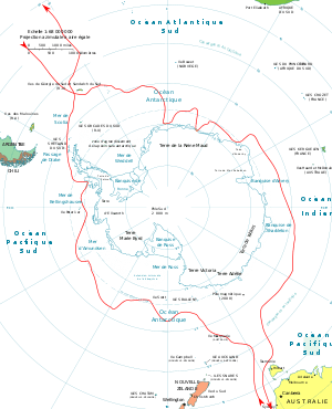
Antarctic territories
| Date | Country | Territory | Claim limits | Map |
|---|---|---|---|---|
| 1840 | 142°02′E to 136°11′E |  | ||
| 1908 | 080°00′W to 020°00′W including overlaps:
|
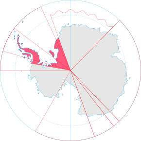 | ||
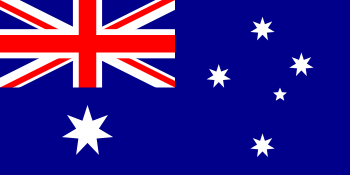
| 1923 | 160°00′E to 150°00′W |  | ||
| 1929 | 68°50′S 90°35′W | .svg.png) | ||
| 1933 | 044°38′E to 136°11′E, and 142°02′E to 160°00′E |  | ||
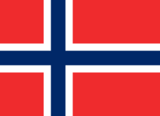
| 1939 | 020°00′W to 044°38′E | .svg.png) | ||
| 1940 | 090°00′W to 053°00′W including overlaps:
|
 | ||
| 1943 | 074°00′W to 025°00′W including overlaps:
|
 | ||
| – | (none) | Unclaimed territory (Marie Byrd Land) |
150°00′W to 090°00′W (except Peter I Island) |
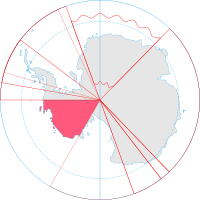 |
The Argentine, British and Chilean claims all overlap, and have caused friction. On 18 December 2012, the British Foreign and Commonwealth Office named a previously unnamed area Queen Elizabeth Land in tribute to Queen Elizabeth II's Diamond Jubilee.[118] On 22 December 2012, the UK ambassador to Argentina, John Freeman, was summoned to the Argentine government as protest against the claim.[119] Argentine–UK relations had previously been damaged throughout 2012 due to disputes over the sovereignty of the nearby Falkland Islands, and the 30th anniversary of the Falklands War.
The areas shown as Australia's and New Zealand's claims were British territory until they were handed over following the countries' independence. Australia currently claims the largest area. The claims of Britain, Australia, New Zealand, France and Norway are all recognised by each other.[120]
Other countries participating as members of the Antarctic Treaty have a territorial interest in Antarctica, but the provisions of the Treaty do not allow them to make their claims while it is in force.[121][122]


Economy
There is no economic activity in Antarctica at present, except for fishing off the coast and small-scale tourism, both based outside Antarctica.[1]
Although coal, hydrocarbons, iron ore, platinum, copper, chromium, nickel, gold and other minerals have been found, they have not been in large enough quantities to exploit.[125] The 1991 Protocol on Environmental Protection to the Antarctic Treaty also restricts a struggle for resources. In 1998, a compromise agreement was reached to place an indefinite ban on mining, to be reviewed in 2048, further limiting economic development and exploitation. The primary economic activity is the capture and offshore trading of fish. Antarctic fisheries in 2000–01 reported landing 112,934 tonnes.[126]
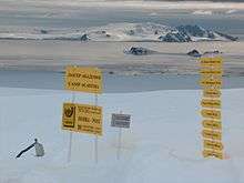
Small-scale "expedition tourism" has existed since 1957 and is currently subject to Antarctic Treaty and Environmental Protocol provisions, but in effect self-regulated by the International Association of Antarctica Tour Operators (IAATO). Not all vessels associated with Antarctic tourism are members of IAATO, but IAATO members account for 95% of the tourist activity. Travel is largely by small or medium ship, focusing on specific scenic locations with accessible concentrations of iconic wildlife. A total of 37,506 tourists visited during the 2006–07 Austral summer with nearly all of them coming from commercial ships; 38,478 were recorded in 2015–16.[127][128][129] As of 2015, there are two Wells Fargo ATMs in Antarctica.[130]
There has been some concern over the potential adverse environmental and ecosystem effects caused by the influx of visitors. Some environmentalists and scientists have made a call for stricter regulations for ships and a tourism quota.[131] The primary response by Antarctic Treaty Parties has been to develop, through their Committee for Environmental Protection and in partnership with IAATO, "site use guidelines" setting landing limits and closed or restricted zones on the more frequently visited sites. Antarctic sightseeing flights (which did not land) operated out of Australia and New Zealand until the fatal crash of Air New Zealand Flight 901 in 1979 on Mount Erebus, which killed all 257 aboard. Qantas resumed commercial overflights to Antarctica from Australia in the mid-1990s.
Antarctic fisheries in 1998–99 (1 July – 30 June) reported landing 119,898 tonnes legally.[132]
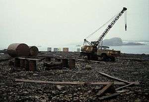
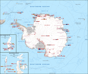
About thirty countries maintain about seventy research stations (40-year-round or permanent, and 30 summer-only) in Antarctica, with an approximate population of 4000 in summer and 1000 in winter.[1]
The ISO 3166-1 alpha-2 "AQ" is assigned to the entire continent regardless of jurisdiction. Different country calling codes and currencies[133] are used for different settlements, depending on the administrating country. The Antarctican dollar, a souvenir item sold in the United States and Canada, is not legal tender.[1][134]
Research
Each year, scientists from 28 different nations conduct experiments not reproducible in any other place in the world. In the summer more than 4,000 scientists operate research stations; this number decreases to just over 1,000 in the winter.[1] McMurdo Station, which is the largest research station in Antarctica, is capable of housing more than 1,000 scientists, visitors, and tourists.
Researchers include biologists, geologists, oceanographers, physicists, astronomers, glaciologists, and meteorologists. Geologists tend to study plate tectonics, meteorites from outer space, and resources from the breakup of the supercontinent Gondwana. Glaciologists in Antarctica are concerned with the study of the history and dynamics of floating ice, seasonal snow, glaciers, and ice sheets. Biologists, in addition to examining the wildlife, are interested in how harsh temperatures and the presence of people affect adaptation and survival strategies in a wide variety of organisms. Medical physicians have made discoveries concerning the spreading of viruses and the body's response to extreme seasonal temperatures. Astrophysicists at Amundsen–Scott South Pole Station study the celestial dome and cosmic microwave background radiation. Many astronomical observations are better made from the interior of Antarctica than from most surface locations because of the high elevation, which results in a thin atmosphere; low temperature, which minimises the amount of water vapour in the atmosphere; and absence of light pollution, thus allowing for a view of space clearer than anywhere else on Earth. Antarctic ice serves as both the shield and the detection medium for the largest neutrino telescope in the world, built 2 km (1.2 mi) below Amundsen–Scott station.[135]
Since the 1970s an important focus of study has been the ozone layer in the atmosphere above Antarctica. In 1985, three British scientists working on data they had gathered at Halley Station on the Brunt Ice Shelf discovered the existence of a hole in this layer. It was eventually determined that the destruction of the ozone was caused by chlorofluorocarbons (CFCs) emitted by human products. With the ban of CFCs in the Montreal Protocol of 1989, climate projections indicate that the ozone layer will return to 1980 levels between 2050 and 2070.[136]
In September 2006 NASA satellite data revealed that the Antarctic ozone hole was larger than at any other time on record, at 2,750,000 km2 (1,060,000 sq mi).[137] The impacts of the depleted ozone layer on climate changes occurring in Antarctica are not well understood.[136]
In 2007 The Polar Geospatial Center was founded. The Polar Geospatial Center uses geospatial and remote sensing technology to provide mapping services to American federally funded research teams. Currently, the Polar Geospatial Center can image all of Antarctica at 500 mm (20 in) resolution every 45 days.[138]
On 6 September 2007 Belgian-based International Polar Foundation unveiled the Princess Elisabeth station, the world's first zero-emissions polar science station in Antarctica to research climate change. Costing $16.3 million, the prefabricated station, which is part of the International Polar Year, was shipped to the South Pole from Belgium by the end of 2008 to monitor the health of the polar regions. Belgian polar explorer Alain Hubert stated: "This base will be the first of its kind to produce zero emissions, making it a unique model of how energy should be used in the Antarctic." Johan Berte is the leader of the station design team and manager of the project which conducts research in climatology, glaciology and microbiology.[139]
In January 2008 British Antarctic Survey (BAS) scientists, led by Hugh Corr and David Vaughan, reported (in the journal Nature Geoscience) that 2,200 years ago, a volcano erupted under Antarctica's ice sheet (based on airborne survey with radar images). The biggest eruption in Antarctica in the last 10,000 years, the volcanic ash was found deposited on the ice surface under the Hudson Mountains, close to Pine Island Glacier.[140]
A study from 2014 estimated that during the Pleistocene, the East Antarctic Ice Sheet (EAIS) thinned by at least 500 m (1,600 ft), and that thinning since the Last Glacial Maximum for the EAIS area is less than 50 m (160 ft) and probably started after c. 14 ka.[141]
Meteorites

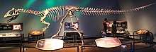
Meteorites from Antarctica are an important area of study of material formed early in the solar system; most are thought to come from asteroids, but some may have originated on larger planets. The first meteorite was found in 1912, and named the Adelie Land meteorite. In 1969, a Japanese expedition discovered nine meteorites. Most of these meteorites have fallen onto the ice sheet in the last million years. Motion of the ice sheet tends to concentrate the meteorites at blocking locations such as mountain ranges, with wind erosion bringing them to the surface after centuries beneath accumulated snowfall. Compared with meteorites collected in more temperate regions on Earth, the Antarctic meteorites are well-preserved.[142]
This large collection of meteorites allows a better understanding of the abundance of meteorite types in the solar system and how meteorites relate to asteroids and comets. New types of meteorites and rare meteorites have been found. Among these are pieces blasted off the Moon, and probably Mars, by impacts. These specimens, particularly ALH84001 discovered by ANSMET, are at the centre of the controversy about possible evidence of microbial life on Mars. Because meteorites in space absorb and record cosmic radiation, the time elapsed since the meteorite hit the Earth can be determined from laboratory studies. The elapsed time since fall, or terrestrial residence age, of a meteorite represents more information that might be useful in environmental studies of Antarctic ice sheets.[142]
In 2006 a team of researchers from Ohio State University used gravity measurements by NASA's GRACE satellites to discover the 500-kilometre-wide (300 mi) Wilkes Land crater, which probably formed about 250 million years ago.[143]
In January 2013 an 18 kg (40 lb) meteorite was discovered frozen in ice on the Nansen ice field by a Search for Antarctic Meteorites, Belgian Approach (SAMBA) mission.[144]
In January 2015 reports emerged of a 2-kilometre (1.2 mi) circular structure, supposedly a meteorite crater, on the surface snow of King Baudouin Ice Shelf. Satellite images from 25 years ago seemingly show it.
Ice mass and global sea level
Due to its location at the South Pole, Antarctica receives relatively little solar radiation except along the southern summer. This means that it is a very cold continent where water is mostly in the form of ice. Precipitation is low (most of Antarctica is a desert) and almost always in the form of snow, which accumulates and forms a giant ice sheet which covers the land. Parts of this ice sheet form moving glaciers known as ice streams, which flow towards the edges of the continent. Next to the continental shore are many ice shelves. These are floating extensions of outflowing glaciers from the continental ice mass. Offshore, temperatures are also low enough that ice is formed from seawater through most of the year. It is important to understand the various types of Antarctic ice to understand possible effects on sea levels and the implications of global cooling.
Sea ice extent expands annually in the Antarctic winter and most of this ice melts in the summer. This ice is formed from the ocean water and floats in the same water and thus does not contribute to rise in sea level. The extent of sea ice around Antarctica (in terms of square kilometers of coverage) has remained roughly constant in recent decades, although the amount of variation it has experienced in its thickness is unclear.[145][146]
Melting of floating ice shelves (ice that originated on the land) does not in itself contribute much to sea-level rise (since the ice displaces only its own mass of water). However, it is the outflow of the ice from the land to form the ice shelf which causes a rise in global sea level. This effect is offset by snow falling back onto the continent. Recent decades have witnessed several dramatic collapses of large ice shelves around the coast of Antarctica, especially along the Antarctic Peninsula. Concerns have been raised that disruption of ice shelves may result in increased glacial outflow from the continental ice mass.[147]
On the continent itself, the large volume of ice present stores around 70% of the world's fresh water.[51] This ice sheet is constantly gaining ice from snowfall and losing ice through outflow to the sea.
Sheperd et al. 2012, found that different satellite methods for measuring ice mass and change were in good agreement and combining methods leads to more certainty with East Antarctica, West Antarctica, and the Antarctic Peninsula changing in mass by +14 ± 43, −65 ± 26, and −20 ± 14 gigatonnes (Gt) per year.[148] The same group's 2018 systematic review study estimated that ice loss across the entire continent was 43 gigatonnes per year on average during the period from 1992 to 2002 but has accelerated to an average of 220 gigatonnes per year during the five years from 2012 to 2017.[149] NASA's Climate Change website indicates a compatible overall trend of greater than 100 gigatonnes of ice loss per year since 2002.[150]
A single 2015 study by H. Jay Zwally et al. found instead that the net change in ice mass is slightly positive at approximately 82 gigatonnes per year (with significant regional variation) which would result in Antarctic activity reducing global sea-level rise by 0.23 mm per year.[151] However, one critic, Eric Rignot of NASA's Jet Propulsion Laboratory, states that this outlying study's findings "are at odds with all other independent methods: re-analysis, gravity measurements, mass budget method, and other groups using the same data" and appears to arrive at more precise values than current technology and mathematical approaches would permit.[152]
A satellite record revealed that the overall increase in Antarctic sea ice extents reversed in 2014, with rapid rates of decrease in 2014–2017 reducing the Antarctic sea ice extents to their lowest values in the 40-y record.[153]
East Antarctica is a cold region with a ground base above sea level and occupies most of the continent. This area is dominated by small accumulations of snowfall which becomes ice and thus eventually seaward glacial flows. The mass balance of the East Antarctic Ice Sheet as a whole is thought to be slightly positive (lowering sea level) or near to balance.[154][155][156] However, increased ice outflow has been suggested in some regions.[155][157]
Effects of global warming
Some of Antarctica has been warming up; particularly strong warming has been noted on the Antarctic Peninsula. A study by Eric Steig published in 2009 noted for the first time that the continent-wide average surface temperature trend of Antarctica is slightly positive at >0.05 °C (0.09 °F) per decade from 1957 to 2006. This study also noted that West Antarctica has warmed by more than 0.1 °C (0.2 °F) per decade in the last 50 years, and this warming is strongest in winter and spring. This is partly offset by autumn cooling in East Antarctica.[158] There is evidence from one study that Antarctica is warming as a result of human carbon dioxide emissions,[159] but this remains ambiguous.[160] The amount of surface warming in West Antarctica, while large, has not led to appreciable melting at the surface, and is not directly affecting the West Antarctic Ice Sheet's contribution to sea level. Instead the recent increases in glacier outflow are believed to be due to an inflow of warm water from the deep ocean, just off the continental shelf.[161][162] The net contribution to sea level from the Antarctic Peninsula is more likely to be a direct result of the much greater atmospheric warming there.[163]
In 2002 the Antarctic Peninsula's Larsen-B ice shelf collapsed.[164] Between 28 February and 8 March 2008, about 570 km2 (220 sq mi) of ice from the Wilkins Ice Shelf on the southwest part of the peninsula collapsed, putting the remaining 15,000 km2 (5,800 sq mi) of the ice shelf at risk. The ice was being held back by a "thread" of ice about 6 km (4 mi) wide,[165][166] prior to its collapse on 5 April 2009.[167][168] According to NASA, the most widespread Antarctic surface melting of the past 30 years occurred in 2005, when an area of ice comparable in size to California briefly melted and refroze; this may have resulted from temperatures rising to as high as 5 °C (41 °F).[169]
A study published in Nature Geoscience in 2013 (online in December 2012) identified central West Antarctica as one of the fastest-warming regions on Earth. The researchers present a complete temperature record from Antarctica's Byrd Station and assert that it "reveals a linear increase in annual temperature between 1958 and 2010 by 2.4±1.2 °C".[170]
In February 2020, the region recorded the highest temperature of 18.3 degree Celsius which was a degree higher than the previous record of 17.5 degrees in March 2015.[171]
Ozone depletion
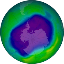
There is a large area of low ozone concentration or "ozone hole" over Antarctica. This hole covers almost the whole continent and was at its largest in September 2008, when the longest lasting hole on record remained until the end of December.[172] The hole was detected by scientists in 1985[173] and has tended to increase over the years of observation. The ozone hole is attributed to the emission of chlorofluorocarbons or CFCs into the atmosphere, which decompose the ozone into other gases.[174] In 2019, the ozone hole was at its smallest in the previous thirty years, due to the warmer polar stratosphere weakening the polar vortex. This reduced the formation of the 'polar stratospheric clouds' that enable the chemistry that leads to rapid ozone loss.[175]
Some scientific studies suggest that ozone depletion may have a dominant role in governing climatic change in Antarctica (and a wider area of the Southern Hemisphere).[173] Ozone absorbs large amounts of ultraviolet radiation in the stratosphere. Ozone depletion over Antarctica can cause a cooling of around 6 °C in the local stratosphere. This cooling has the effect of intensifying the westerly winds which flow around the continent (the polar vortex) and thus prevents outflow of the cold air near the South Pole. As a result, the continental mass of the East Antarctic ice sheet is held at lower temperatures, and the peripheral areas of Antarctica, especially the Antarctic Peninsula, are subject to higher temperatures, which promote accelerated melting.[173] Models also suggest that the ozone depletion/enhanced polar vortex effect also accounts for the recent increase in sea ice just offshore of the continent.[176]
See also
Notes
- The word was originally pronounced with the first c silent in English, but the spelling pronunciation has become common and is often considered more correct. The pronunciation with a silent c, and even with the first t silent as well, is however widespread and typical of many similar English words.[2] The c had ceased to be pronounced in Medieval Latin and was dropped from the spelling in Old French, but it was added back for etymological reasons in English in the 17th century and thereafter began to be pronounced, but (as with other spelling pronunciations) at first only by less educated people.[3][4] For those who pronounce the first t, there is also variation between the pronunciations Ant-ar(c)tica and An-tar(c)tica.
References
- United States Central Intelligence Agency (2011). "Antarctica". The World Factbook. Government of the United States. Retrieved 14 September 2017.
- Antarctica Archived 8 December 2015 at the Wayback Machine. American Heritage Dictionary
- Crystal, David (2006). The Fight for English. Oxford University Press. p. 172. ISBN 978-0-19-920764-0.
- Harper, Douglas. "Antarctic". Online Etymology Dictionary. Retrieved 16 November 2011.
- Fretwell, P.; Pritchard, H. D.; Vaughan, D. G.; Bamber, J. L.; Barrand, N. E.; et al. (28 February 2013). "Bedmap2: improved ice bed, surface and thickness datasets for Antarctica" (PDF). The Cryosphere. 7 (1): 390. Bibcode:2013TCry....7..375F. doi:10.5194/tc-7-375-2013. Retrieved 6 January 2014.
- "La Antártida" (in Spanish). Dirección Nacional del Antártico. Archived from the original on 13 November 2016. Retrieved 13 November 2016.
- Joyce, C. Alan (18 January 2007). "The World at a Glance: Surprising Facts". The World Almanac. Archived from the original on 4 March 2009. Retrieved 7 February 2009.
- "Coldest temperature ever recorded on Earth in Antarctica: -94.7C (−135.8F)". The Guardian. Associated Press. 10 December 2013. Retrieved 12 July 2017.
- Liddell, Henry George; Scott, Robert. "Antarktikos". In Crane, Gregory R. (ed.). A Greek–English Lexicon. Perseus Digital Library. Tufts University. Retrieved 18 November 2011.
- Hince, Bernadette (2000). The Antarctic Dictionary. CSIRO Publishing. p. 6. ISBN 978-0-9577471-1-1.
- Aristotle Meteorologica. Book II, Part 5. 350 BCE. Translated by E. Webster. Oxford: Clarendon Press, 1923. 140 pp.
- Hyginus. De astronomia. Ed. G. Viré. Stuttgart: Teubner, 1992. 176 pp.
- Apuleii. Opera omnia. Volumen tertium. London: Valpy, 1825. 544 pp.
- G. Chaucer. A Treatise on the Astrolabe. Approx. 1391. Ed. W. Skeat. London: N. Trübner, 1872. 188 pp.
- Barth, Cyriaco Jacob zum (1545). Astronomia: Teutsch Astronomei. Frankfurt.
- Cameron-Ash, M. (2018). Lying for the Admiralty: Captain Cook's Endeavour Voyage. Sydney: Rosenberg. p. 20. ISBN 978-0-6480439-6-6.
- John George Bartholomew and the naming of Antarctica, CAIRT Issue 13, National Library of Scotland, July 2008, ISSN 1477-4186, and also "The Bartholomew Archive".
- Beaglehole, J.C. (1968). Cook, Journals, vol.2. Cambridge: Hakluyt Society. p. 643, n.3. ISBN 978-1-4724-5324-2.
- Flinders, Matthew. A voyage to Terra Australis (Introduction) Archived 11 November 2012 at the Wayback Machine. Retrieved 25 January 2013.
- "Age of Exploration: John Cook". The Mariners' Museum. Archived from the original on 7 February 2006. Retrieved 12 February 2006.
- James Cook, The Journals, edited by Philip Edwards. Penguin Books, 2003, p. 250.
- U.S. Antarctic Program External Panel of the National Science Foundation. "Antarctica—Past and Present" (PDF). Government of the United States. Archived (PDF) from the original on 17 February 2006. Retrieved 6 February 2006.
- Guthridge, Guy G. "Nathaniel Brown Palmer, 1799–1877". Government of the United States, National Aeronautics and Space Administration. Archived from the original on 2 February 2006. Retrieved 6 February 2006.
- "Palmer Station". University of the City of San Diego. Archived from the original on 10 February 2006. Retrieved 3 March 2008.
- "Экспозиции: Антарктика" [Exhibition: Antarctica].
- "An Antarctic Time Line: 1519–1959". South-Pole.com. Archived from the original on 10 February 2006. Retrieved 12 February 2006.
- "Antarctic Explorers Timeline: Early 1800s". Polar Radar for Ice Sheet Measurements (PRISM). Retrieved 12 February 2006.
- Erki Tammiksaar (14 December 2013). "Punane Bellingshausen" [Red Bellingshausen]. Postimees.Arvamus. Kultuur (in Estonian).
- Armstrong, Terence (September 1971). "Bellingshausen and the discovery of Antarctica". Polar Record. 15 (99): 887–889. doi:10.1017/S0032247400062112.
- Bourke, Jane (2004). Amazing Antarctica. Ready-Ed Publications. ISBN 978-1-86397-584-1.
- Joyner, Christopher C. (1992). Antarctica and the Law of the Sea. Martinus Nijhoff Publishers. p. 5.
- Primary society and environment Book F. Australia: R.I.C. Publications. 2001. p. 96. ISBN 978-1-74126-127-1.
- "Proposition de classement du rocher du débarquement dans le cadre des sites et monuments historiques" (in French). Antarctic Treaty Consultative meeting 2006, note 4.
- "Voyage au Pôle sud et dans l'Océanie sur les corvettes "l'Astrolabe" et "la Zélée", exécuté par ordre du Roi pendant les années 1837-1838-1839-1840 sous le commandement de M.J. Dumont-d'Urville, capitaine de vaisseau" (in French). Vol. 8. Paris: Gide publisher. 1842–1846. pp. 149–152. gallica.bnf.fr, BNF.
- "South-Pole – Exploring Antarctica". South-Pole.com. Archived from the original on 14 February 2006. Retrieved 12 February 2006.
- "Antarctic Circle – Antarctic First". 9 February 2005. Archived from the original on 8 February 2006. Retrieved 12 February 2006.
- "Tannatt William Edgeworth David". Australian Antarctic Division. Archived from the original on 29 September 2010. Retrieved 27 September 2010.
- "Roald Amundsen". South-Pole.com. Archived from the original on 5 February 2006. Retrieved 9 February 2006.
- "Richard Byrd". 70South.com. Archived from the original on 11 October 2007. Retrieved 12 February 2006.
- "Women in Antarctica: Sharing this Life-Changing Experience", transcript of speech by Robin Burns, given at the 4th Annual Phillip Law Lecture; Hobart, Tasmania, Australia; 18 June 2005. Retrieved 5 August 2010.
- "The first woman in Antarctica". www.antarctica.gov.au. Australian Antarctic Division. 2012. Retrieved 27 June 2016.
- Blackadder, Jesse (October 2013). Illuminations : casting light upon the earliest female travellers to Antarctica (Doctor of Creative Arts). University of Western Sydney.
- Bogen, H. (1957). Main events in the history of Antarctic exploration. Sandefjord: Norwegian Whaling Gazette, page 85
- "Dates in American Naval History: October". Naval History and Heritage Command. United States Navy. Archived from the original on 26 June 2004. Retrieved 12 February 2006.
- "First Women at Pole". South Pole Station. Retrieved 24 August 2016.
- Accident description for ZK-NZP at the Aviation Safety Network. Retrieved on 24 August 2011.
- Ousland, Børge (13 December 2013). "Børge Ousland: How I crossed Antarctica alone". The Guardian. ISSN 0261-3077. Retrieved 30 December 2018.
- "O'Brady's Antarctic Crossing: Was It Really Unassisted?". Explorersweb. Retrieved 29 December 2018.
- "Fastest unsupported (kite assisted) journey to the South Pole taking just 34 days". www.guinnessworldrecords.com.
- Drewry, D.J., ed. (1983). Antarctica: Glaciological and Geophysical Folio. Scott Polar Research Institute, University of Cambridge. ISBN 978-0-901021-04-5.
- "How Stuff Works: polar ice caps". howstuffworks.com. 21 September 2000. Archived from the original on 4 February 2006. Retrieved 12 February 2006.
- British Antarctic Survey. "Volcanoes". Natural Environment Research Council. Archived from the original on 11 July 2007. Retrieved 13 February 2006.
- "Scientists Discover Undersea Volcano Off Antarctica". United States National Science Foundation. Retrieved 13 February 2006.
- Briggs, Helen (19 April 2006). "Secret rivers found in Antarctic". BBC News. Retrieved 7 February 2009.
- "Lake Vostok". United States National Science Foundation. Retrieved 13 February 2006.
- Abe, Shige; Bortman, Henry (13 April 2001). "Focus on Europa". NASA. Archived from the original on 19 October 2014. Retrieved 12 January 2012.
- "Extremophile Hunt Begins". Science News. NASA. Archived from the original on 23 March 2010. Retrieved 22 October 2011.
- Stirone, Shannon (7 September 2018). "New Antarctica Map Is Like 'Putting on Glasses for the First Time and Seeing 20/20' – A high resolution terrain map of Earth's frozen continent will help researchers better track changes on the ice as the planet warms". The New York Times. Retrieved 9 September 2018.
- Klages, Johann P.; Salzmann, Ulrich; Bickert, Torsten; Hillenbrand, Claus-Dieter; Gohl, Karsten; Kuhn, Gerhard; Bohaty, Steven M.; Titschack, Jürgen; Müller, Juliane; Frederichs, Thomas; Bauersachs, Thorsten (April 2020). "Temperate rainforests near the South Pole during peak Cretaceous warmth". Nature. 580 (7801): 81–86. doi:10.1038/s41586-020-2148-5. ISSN 1476-4687. PMID 32238944.
- Stonehouse, B., ed. (June 2002). Encyclopedia of Antarctica and the Southern Oceans. John Wiley & Sons. ISBN 978-0-471-98665-2.
- Smith, Nathan D.; Pol, Diego (2007). "Anatomy of a basal sauropodomorph dinosaur from the Early Jurassic Hanson Formation of Antarctica" (PDF). Acta Palaeontologica Polonica. 52 (4): 657–674.
- Leslie, Mitch (December 2007). "The Strange Lives of Polar Dinosaurs". Smithsonian Magazine. Archived from the original on 30 January 2008. Retrieved 24 January 2008.
- Bornemann, Norris RD; Friedrich, O; Beckmann, B; Schouten, S; Damsté, JS; Vogel, J; Hofmann, P; Wagner, T (2008). "Isotopic evidence for glaciation during the Cretaceous supergreenhouse". Science. 319 (5860): 189–92. Bibcode:2008Sci...319..189B. doi:10.1126/science.1148777. PMID 18187651.
- Reinhold, Robert (21 March 1982). "Antarctica yields first land mammal fossil". New York Times.
- "New CO2 data helps unlock the secrets of Antarctic formation". Physorg.com. Archived from the original on 15 July 2011. Retrieved 26 July 2011.
- DeConto, Robert M.; Pollard, David (16 January 2003). "Rapid Cenozoic glaciation of Antarctica induced by declining atmospheric CO2". Nature. 421 (6920): 245–9. Bibcode:2003Natur.421..245D. doi:10.1038/nature01290. PMID 12529638.
- Trewby, Mary, ed. (September 2002). Antarctica: An Encyclopedia from Abbott Ice Shelf to Zooplankton. Firefly Books. ISBN 978-1-55297-590-9.
- Retallack, G.J.; Krull, E.S.; Bockheim, J.G. (2001). "New grounds for reassessing palaeoclimate of the Sirius Group". Journal of the Geological Society, London. 158 (6): 925–35. Bibcode:2001JGSoc.158..925R. doi:10.1144/0016-764901-030.
- Stefi Weisburd (March 1986). "A forest grows in Antarctica. (an extensive forest may have flourished about 3 million years ago)". Science News. Retrieved 2 November 2012.
- "Antarctica's geology". Royal Geographical Society (with the Institute of British Geographers) in partnership with the British Antarctic Survey and the Foreign and Commonwealth Office. Archived from the original on 22 November 2014. Retrieved 31 October 2014.
- Lear, Caroline H.; Lunt, Dan J. (10 March 2016). "How Antarctica got its ice". Science. 352 (6281): 34–35. Bibcode:2016Sci...352...34L. doi:10.1126/science.aad6284. PMID 26966192.
- Hudson, Gavin (14 December 2008). "The Coldest Inhabited Places on Earth". Eco Localizer. Archived from the original on 27 March 2016. Retrieved 8 February 2009.
- Agee, Ernest; Orton, Andrea; Rogers, John (2013). "CO2Snow Deposition in Antarctica to Curtail Anthropogenic Global Warming". Journal of Applied Meteorology and Climatology. 52 (2): 281–288. Bibcode:2013JApMC..52..281A. doi:10.1175/JAMC-D-12-0110.1. ISSN 1558-8424.
- "Antarctica records unofficial coldest temperature ever". USA Today.
- "Antarctica temperature exceeds 20C for first time". BBC News. 14 February 2020. Retrieved 14 February 2020.
- Watts, Jonathan (13 February 2020). "Antarctic temperature rises above 20C for first time on record". The Guardian. ISSN 0261-3077. Retrieved 14 February 2020.
- British Antarctic Survey. "Weather in the Antarctic". Natural Environment Research Council. Retrieved 9 February 2006.
- The Earth's Elliptical Orbit Around the Sun – Aphelion and Perihelion. Geography.about.com. Retrieved on 21 October 2013.
- "Flock of Antarctica's Orthodox temple celebrates Holy Trinity Day". Serbian Orthodox Church. 24 May 2004. Retrieved 7 February 2009.
- Владимир Петраков: 'Антарктика – это особая атмосфера, где живут очень интересные люди' (in Russian). (Vladimir Petrakov: "Antarctic is a special world, full of very interesting people"). Interview with Father Vladimir Petrakov, a priest who twice spent a year at the station.
- Headland, Robert K. (1984). The Island of South Georgia. Cambridge University Press. pp. 12, 130. ISBN 978-0-521-25274-4. OCLC 473919719.
- Old Antarctic Explorers Association. "THIS QUARTER IN HISTORY" (PDF). Explorer's Gazette. 9 (1): 9. Retrieved 3 December 2019.
- Bone, James (13 November 2007). "The power games that threaten world's last pristine wilderness". The Times.
- "Questions to the Sun for the 2002–03 season". The Antarctic Sun. Archived from the original on 11 February 2006. Retrieved 9 February 2006.
- "Registro Civil Base Esperanza" (in Spanish). Argentine Army. 22 December 2017. Archived from the original on 17 January 2010.
- Corporación de Defensa de la Soberanía. "Derechos soberanos antárticos de Chile" (in Spanish). Retrieved 16 November 2011.
- Antarctic volcanoes help preserve life in the freezer – The Conversation
- British Antarctic Survey. "Land Animals of Antarctica". Natural Environment Research Council. Archived from the original on 7 October 2008. Retrieved 25 April 2017.
- Sandro, Luke; Constible, Juanita. "Antarctic Bestiary – Terrestrial Animals". Laboratory for Ecophysiological Cryobiology, Miami University. Retrieved 22 October 2011.
- Kim, S; Oh, M; Jung, W; Park, J; Choi, HG; Shin, SC (2017). "Genome sequencing of the winged midge, Parochlus steinenii, from the Antarctic Peninsula". Gigascience. 6 (3): 1–8. doi:10.1093/gigascience/giw009. PMC 5467013. PMID 28327954.
- "Snow Petrel Pagodroma nivea". BirdLife International. Retrieved 20 October 2009.
- "Creatures of Antarctica". Archived from the original on 14 February 2005. Retrieved 6 February 2006.
- Kinver, Mark (15 February 2009). "Ice oceans 'are not poles apart'". BBC News. British Broadcasting Corporation. Retrieved 22 October 2011.
- British Antarctic Survey. "Plants of Antarctica". Natural Environment Research Council. Archived from the original on 7 June 2011. Retrieved 12 July 2011.
- Bridge, Paul D.; Spooner, Brian M.; Roberts, Peter J. (2008). "Non-lichenized fungi from the Antarctic region". Mycotaxon. 106: 485–490. Archived from the original on 11 August 2013. Retrieved 22 October 2011.
- Onofri, S.; Selbmann, L.; Zucconi, L.; Scalzi, G.; Venkateswaran, K.J.; de la Torre, R.; de Vera, J.-P.; Ott, S.; Rabbow, E. & Horneck, G. "Survival of Black Fungi in Space, Preliminary Results" (PDF). Retrieved 13 March 2013.
- de Hoog, G.S. (2005). "Fungi of the Antarctic: evolution under extreme conditions". Studies in Mycology. 51: 1–79.
- "Antarctica was once green: Scientists". 15 April 2017. Archived from the original on 23 April 2017.
- Chwedorzewska, K.J. (2015). "Poa annua L. in the maritime Antarctic: an overview". Polar Record. 51 (6): 637–643. doi:10.1017/S0032247414000916.
- Australian Antarctic Division. "Antarctic Wildlife". Government of Australia. Archived from the original on 28 August 2010. Retrieved 27 September 2010.
- Gorman, James (6 February 2013). "Bacteria Found Deep Under Antarctic Ice, Scientists Say". The New York Times. Retrieved 6 February 2013.
- Bridge, Paul D.; Hughes, Kevin. A. (2010). "Conservation issues for Antarctic fungi". Mycologia Balcanica. 7 (1): 73–76. Archived from the original on 11 August 2013. Retrieved 12 July 2011.
- Kirby, Alex (15 August 2001). "Toothfish at risk from illegal catches". BBC News. Retrieved 22 October 2011.
- "Toothfish". Australian Antarctic Division. Retrieved 22 October 2011.
- Rogan-Finnemore, Michelle (2005). "What Bioprospecting Means for Antarctica and the Southern Ocean". In Von Tigerstrom, Barbara (ed.). International Law Issues in the South Pacific. Ashgate Publishing. p. 204. ISBN 978-0-7546-4419-4. "Australia, New Zealand, France, Norway and the United Kingdom reciprocally recognize the validity of each other's claims."
- Rapp, Ole Magnus (21 September 2015). "Norge utvider Dronning Maud Land helt frem til Sydpolen". Aftenposten (in Norwegian). Oslo, Norway. Retrieved 22 September 2015.
... formålet med anneksjonen var å legge under seg det landet som til nå ligger herreløst og som ingen andre enn nordmenn har kartlagt og gransket. Norske myndigheter har derfor ikke motsatt seg at noen tolker det norske kravet slik at det går helt opp til og inkluderer polpunktet.
- "Antarctic Treaty System – Parties". Antarctic Treaty and the Secretariat. Retrieved 20 October 2009.
- "Mining Issues in Antarctica" (PDF). Antarctica New Zealand. Archived from the original (PDF) on 10 May 2005. Retrieved 1 September 2003.
- "Antarctic and Southern Ocean Coalition". Antarctic and Southern Ocean Coalition. Archived from the original on 25 July 2011. Retrieved 26 July 2011.
- "World Park Antarctica". Greenpeace.org. Greenpeace International. 25 February 2010. Archived from the original on 15 March 2010. Retrieved 26 July 2011.
- "Greenpeace applauds Antarctic protection victory" (Press release). Greenpeace International. 14 January 1998. Archived from the original on 20 February 2006.
- "Antarctica: exploration or exploitation?". New Scientist. 22 June 1991.
- "Antarctica, a tale of two treaties". New Scientist. Retrieved 27 May 2008.
- "The Madrid Protocol". Australian Antarctic Division. Retrieved 22 October 2011.
- Bobo, Jack A. "Antarctic Treaty Papers". Archived from the original on 23 May 2011. Retrieved 19 October 2009.
- "Antarctic Treaty". Scientific Committee on Antarctic Research. Archived from the original on 6 February 2006. Retrieved 9 February 2006.
- "Argentina in Antarctica". Antarctica Institute of Argentina. Archived from the original on 6 March 2006. Retrieved 9 February 2006.
- "The Foreign Secretary has announced that the southern part of British Antarctic Territory has been named Queen Elizabeth Land". Foreign & Commonwealth Office. HM Government. 18 December 2012. Retrieved 22 December 2012.
- "Argentina angry after Antarctic territory named after Queen". BBC News. British Broadcasting Corporation. 22 December 2012. Retrieved 22 December 2012.
- Rogan-Finnemore, Michelle (2005). "What Bioprospecting Means for Antarctica and the Southern Ocean". In Von Tigerstrom, Barbara (ed.). International Law Issues in the South Pacific. Ashgate Publishing. p. 204. ISBN 0-7546-4419-7.
- "La Antartica". Library.jid.org. Archived from the original on 7 October 2008. Retrieved 4 November 2008.
- Afese.com Archived 7 July 2011 at the Wayback Machine. (PDF) . Retrieved on 19 July 2011.
- Morris, Michael (1988). The Strait of Magellan. Martinus Nijhoff Publishers. p. 219. ISBN 978-0-7923-0181-3. Retrieved 21 October 2010.
... Brazil has even designated a zone of Antarctic interest that overlaps the Argentine sector but not the Chilean one ...
- "Disputes – international". The World Factbook. United States Central Intelligence Agency. 2011. Retrieved 22 October 2011.
... the US and Russia reserve the right to make claims ...
- "Natural Resources". The World Factbook. CIA. Retrieved 30 October 2016.
- "Fisheries News". mecropress. 30 November 2003. Retrieved 30 October 2016.
- "Final Report, 30th Antarctic Treaty Consultative Meeting". Antarctic Treaty Secretariat. Archived from the original (DOC) on 8 August 2007. Retrieved 2 August 2007.
- "Politics of Antarctica". Archived from the original on 14 February 2005. Retrieved 5 February 2006.
- "2015–2016 Tourists by Nationality Total". IAATO. Archived from the original on 10 November 2016. Retrieved 30 January 2017.
- "The World's Loneliest ATM is in Antarctica". mentalfloss.com. 5 May 2015. Retrieved 30 August 2019.
- Rowe, Mark (11 February 2006). "Tourism threatens Antarctic". London: Telegraph UK. Retrieved 5 February 2006.
- Guthridge, Guy (1999). "Antarctica in 1999". Britannica Book of the Year.
- see ISO 4217
- Symes, Peter (2002). "Private Issues – The Antarctica Issues and the NORFED Issues". Retrieved 22 November 2016.
- "Science in Antarctica". Antarctic Connection. Archived from the original on 7 February 2006. Retrieved 4 February 2006.
- Graham, Rex (15 July 2014). "Adelie Penguins thriving amid Antarctica's melting ice". Archived from the original on 5 June 2016. Retrieved 24 October 2014.
- "NASA and NOAA Announce Ozone Hole is a Double Record Breaker". Goddard Space Flight Center, NASA. 19 October 2006. Archived from the original on 13 October 2010. Retrieved 6 September 2010.
- Rejcek, Peter (2 December 2013). "Polar Geospatial Center Releases New Application with High-Res Satellite Imagery". The Antarctic Sun. Retrieved 24 October 2014.
- Belgian Science Policy Office Archived 4 July 2007 at the Wayback Machine – Princess Elisabeth Station
- Black, Richard (20 January 2008). "Ancient Antarctic eruption noted". BBC News. Archived from the original on 15 January 2009. Retrieved 7 February 2009.
- Yusuke Suganuma; Hideki Miura; Zondervan, Albert; Jun'ichi Okuno (August 2014). "East Antarctic deglaciation and the link to global cooling during the Quaternary: evidence from glacial geomorphology and 10Be surface exposure dating of the Sør Rondane Mountains, Dronning Maud Land". Quaternary Science Reviews. 97: 102–120. Bibcode:2014QSRv...97..102S. doi:10.1016/j.quascirev.2014.05.007.
- "Meteorites from Antarctica". NASA. Archived from the original on 6 March 2006. Retrieved 9 February 2006.
- Gorder, Pam Frost (1 June 2006). "Big Bang in Antarctica—Killer Crater Found Under Ice". Research News. Archived from the original on 6 March 2016.
- "Antarctic scientists find 18 kg meteorite". The New Zealand Herald. 1 March 2013. Retrieved 2 March 2013.
- "Regional changes in Arctic and Antarctic sea ice". United Nations Environment Programme.
- "All About Sea Ice: Characteristics: Arctic vs. Antarctic". National Snow and Ice Data Center. Archived from the original on 17 March 2010.
- Rignot, E.; Casassa, G.; Gogineni, P.; Krabill, W.; Rivera, A.; Thomas, R. (2004). "Accelerated ice discharge from the Antarctic Peninsula following the collapse of Larsen B ice shelf" (PDF). Geophysical Research Letters. 31 (18): L18401. Bibcode:2004GeoRL..3118401R. doi:10.1029/2004GL020697. Archived from the original (PDF) on 23 November 2011. Retrieved 22 October 2011.
- Shepherd, Andrew; Ivins, Erik; et al. (IMBIE team) (30 November 2012). "A Reconciled Estimate of Ice-Sheet Mass Balance" (PDF). Science. 338 (6111): 1183–1189. Bibcode:2012Sci...338.1183S. doi:10.1126/science.1228102. hdl:2060/20140006608. PMID 23197528.
- Shepherd, Andrew; Ivins, Erik; et al. (IMBIE team) (13 June 2018). "Mass balance of the Antarctic Ice Sheet from 1992 to 2017" (PDF). Nature. 558 (7709): 219–222. Bibcode:2018Natur.558..219I. doi:10.1038/s41586-018-0179-y. PMID 29899482. Lay summary – Ars Technica (13 June 2018).
- "Land Ice". NASA Global Climate Change. Retrieved 23 February 2017.
- Zwally, H. Jay; Li, Jun; Robbins, John W.; Saba, Jack L.; Yi, Donghui; Brenner, Anita C. (2015). "Mass gains of the Antarctic ice sheet exceed losses". Journal of Glaciology. Forthcoming (230): 1019. Bibcode:2015JGlac..61.1019Z. doi:10.3189/2015JoG15J071.
- "Study concludes Antarctica is gaining ice, rather than losing it". Ars Technica. 3 November 2015. Retrieved 14 June 2018.
The paper is attracting a lot of criticism from other scientists, however. Eric Rignot, who has worked on similar Antarctic studies, has been fielding a lot of questions about this one and shared his comments with Ars. "I am afraid I have some rather harsh words about it," he wrote. Rignot said the data just aren't precise enough to support the paper's conclusions.¶ "Zwally's group is the only one pushing its interpretation beyond the realm of the inherent uncertainty of the data. Accumulation of snow in East Antarctica is 10 centimeters water equivalent per year. To detect changes in accumulation of 136 gigatons (with no error bar), or 10 percent, Zwally et al. needs to detect changes of the order of 1 centimeter. Current technology such as ICESat cannot detect any change smaller than 20 centimeters. Radar altimetry (used for the earlier period) is closer to 40–50 centimeter noise, but nobody really knows. There is no way to detect changes in East Antarctic accumulation at the 10 percent level, not even 50 percent level, with those kinds of error bars," Rignot wrote.¶ He continued, "The Zwally group's findings are at odds with all other independent methods: re-analysis, gravity measurements, mass budget method, and other groups using the same data."
- Parkinson, Claire L. (26 June 2019). "A 40-y record reveals gradual Antarctic sea ice increases followed by decreases at rates far exceeding the rates seen in the Arctic". Proceedings of the National Academy of Sciences. 116 (29): 14414–14423. Bibcode:2019PNAS..11614414P. doi:10.1073/pnas.1906556116. ISSN 0027-8424. PMC 6642375. PMID 31262810.
- Shepherd, A.; Wingham, D. (2007). "Recent Sea-Level Contributions of the Antarctic and Greenland Ice Sheets". Science. 315 (5818): 1529–1532. Bibcode:2007Sci...315.1529S. doi:10.1126/science.1136776. PMID 17363663. S2CID 8735672.
- Rignot, E.; Bamber, J.L.; Van Den Broeke, M R.; Davis, C.; Li, Y.; Van De Berg, W.J.; Van Meijgaard, E. (2008). "Recent Antarctic ice mass loss from radar interferometry and regional climate modelling". Nature Geoscience. 1 (2): 106. Bibcode:2008NatGe...1..106R. doi:10.1038/ngeo102.
- Sheperd et al. 2012 A Reconciled Estimate of Ice-Sheet Mass Balance
- Chen, J.L.; Wilson, C.R.; Tapley, B.D.; Blankenship, D.; Young, D. (2008). "Antarctic regional ice loss rates from GRACE". Earth and Planetary Science Letters. 266 (1–2): 140–148. Bibcode:2008E&PSL.266..140C. doi:10.1016/j.epsl.2007.10.057.
- Steig, E.J.; Schneider, D.P.; Rutherford, S.D.; Mann, M.E.; Comiso, J.C.; Shindell, D.T. (2009). "Warming of the Antarctic ice-sheet surface since the 1957 International Geophysical Year". Nature. 457 (7228): 459–462. Bibcode:2009Natur.457..459S. doi:10.1038/nature07669. PMID 19158794.
- Gillett, N. P.; Stone, D.I.A.; Stott, P.A.; Nozawa, T.; Karpechko, A.Y.; Hegerl, G.C.; Wehner, M.F.; Jones, P.D. (2008). "Attribution of polar warming to human influence". Nature Geoscience. 1 (11): 750. Bibcode:2008NatGe...1..750G. doi:10.1038/ngeo338.
- Steig, E.J.; Ding, Q.; White, J.W.C.; Küttel, M.; Rupper, S.B.; Neumann, T.A.; Neff, P.D.; Gallant, A.J.E.; Mayewski, P.A.; Taylor, K.C.; Hoffmann, G.; Dixon, D.A.; Schoenemann, S.W.; Markle, B.R.; Fudge, T.J.; Schneider, D.P.; Schauer, A.J.; Teel, R.P.; Vaughn, B.H.; Burgener, L.; Williams, J.; Korotkikh, E. (2013). "Recent climate and ice-sheet changes in West Antarctica compared with the past 2,000 years". Nature Geoscience. 6 (5): 372. Bibcode:2013NatGe...6..372S. doi:10.1038/ngeo1778. hdl:2060/20150001452.
- Payne, A.J.; Vieli, A.; Shepherd, A.P.; Wingham, D.J.; Rignot, E. (2004). "Recent dramatic thinning of largest West Antarctic ice stream triggered by oceans". Geophysical Research Letters. 31 (23): L23401. Bibcode:2004GeoRL..3123401P. CiteSeerX 10.1.1.1001.6901. doi:10.1029/2004GL021284.
- Thoma, M.; Jenkins, A.; Holland, D.; Jacobs, S. (2008). "Modelling Circumpolar Deep Water intrusions on the Amundsen Sea continental shelf, Antarctica" (PDF). Geophysical Research Letters. 35 (18): L18602. Bibcode:2008GeoRL..3518602T. doi:10.1029/2008GL034939.
- Pritchard, H. & D.G. Vaughan (2007). "Widespread acceleration of tidewater glaciers on the Antarctic Peninsula" (PDF). Journal of Geophysical Research. 112. Bibcode:2007JGRF..11203S29P. doi:10.1029/2006JF000597.
- Glasser, Neil (10 February 2008). "Antarctic Ice Shelf Collapse Blamed on More Than Climate Change". ScienceDaily.
- "Huge Antarctic ice chunk collapses". CNN.com. Cable News Network. 25 March 2008. Archived from the original on 29 March 2008. Retrieved 25 March 2008.
- "Massive ice shelf on verge of breakup". CNN.com. Cable News Network. 25 March 2008. Archived from the original on 29 March 2008. Retrieved 26 March 2008.
- "Ice Bridge Holding Antarctic Shelf in Place Shatters". The New York Times. Reuters. 5 April 2009. Archived from the original on 16 April 2009. Retrieved 5 April 2009.
- "Ice bridge ruptures in Antarctic". BBC News. British Broadcasting Corporation. 5 April 2009. Archived from the original on 6 April 2009. Retrieved 5 April 2009.
- "Big area of Antarctica melted in 2005". CNN.com. Cable News Network. Reuters. 16 May 2007. Archived from the original on 18 May 2007. Retrieved 11 June 2007.
- Bromwich, David H.; Nicolas, Julien P.; Monaghan, Andrew J.; Lazzara, Matthew A.; Keller, Linda M.; Weidner, George A.; Wilson, Aaron B. (2013). "Central West Antarctica among the most rapidly warming regions on Earth". Nature Geoscience. 6 (2): 139–145. Bibcode:2013NatGe...6..139B. CiteSeerX 10.1.1.394.1974. doi:10.1038/ngeo1671.
- "Antarctica appears to have broken a heat record". m.phys.org. Retrieved 9 February 2020.
- British Antarctic Survey, Meteorology and Ozone Monitoring Unit. "Antarctic Ozone". Natural Environment Research Council. Retrieved 5 May 2009.
- Schiermeier, Quirin (12 August 2009). "Atmospheric science: Fixing the sky". Nature. 460 (7257): 792–795. doi:10.1038/460792a. PMID 19675624.
- National Aeronautics and Space Administration, Advanced Supercomputing Division (NAS) (26 June 2001). "The Antarctic Ozone hole". Government of the United States. Archived from the original on 3 April 2009. Retrieved 7 February 2009.
- "Ozone hole set to close". Space Daily. Space Media Network. 12 November 2019. Retrieved 8 December 2019.
- Turner J.; Comiso J.C.; Marshall G.J.; Lachlan-Cope T.A.; Bracegirdle T.; Maksym T.; Meredith M.P., Wang Z.; Orr A. (2009). "Non-annular atmospheric circulation change induced by stratospheric ozone depletion and its role in the recent increase of Antarctic sea ice extent" (PDF). Geophysical Research Letters. 36 (8): L08502. Bibcode:2009GeoRL..36.8502T. doi:10.1029/2009GL037524.
External links
- High resolution map (2018) – Reference Elevation Model of Antarctica (REMA)
- Antarctica. on In Our Time at the BBC
- Antarctic region at Curlie
- "Antarctica". The World Factbook. Central Intelligence Agency.
- British Services Antarctic Expedition 2012
- Antarctic Treaty Secretariat, de facto government
- British Antarctic Survey (BAS)
- U.S. Antarctic Program Portal
- Australian Antarctic Division
- Portals on the World – Antarctica from the Library of Congress
- NASA's LIMA (Landsat Image Mosaic of Antarctica) (USGS mirror)
- The Antarctic Sun (Online newspaper of the U.S. Antarctic Program)
- Antarctica and New Zealand (NZHistory.net.nz)
- Journey to Antarctica in 1959
- Listen to Ernest Shackleton describing his 1908 South Pole Expedition
- Map of Antarctican subglacial lakes
- Video: The Bedrock Beneath Antarctica
- Slang used in Antarctica
- The Papers of Henry Francis Jr. at Dartmouth College Library
| General |
| |
|---|---|---|
| Geographic regions | ||
| Waterways | ||
| Famous explorers | ||
Continents of the world | ||||||
|---|---|---|---|---|---|---|
| ||||||
| ||||||
.svg.png)
.svg.png)
.svg.png)
.svg.png)
_political.svg.png)
.svg.png)
.svg.png)
.svg.png)
Countries and territories bordering the Indian Ocean | ||
|---|---|---|
| Africa |  | |
| Asia |
| |
| Other | ||
| Authority control |
|
|---|