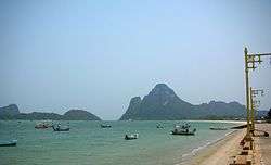
Prachuap Bay
Prachuap Bay (Thai: อ่าวประจวบ) is a bay in the west side of the Gulf of Siam or Gulf of Thailand.[1] It lies off Prachuap Khiri Khan town, Prachuap Khiri Khan Province.
| Prachuap Bay อ่าวประจวบ | |
|---|---|
 Prachuap Bay | |
 Prachuap Bay อ่าวประจวบ Location off the coast of Thailand | |
| Coordinates | 11°48′50″N 99°48′50″E |
| Type | Marine bay |
| Primary outflows | Gulf of Siam |
| Basin countries | Thailand |
Geography
Prachuap Bay lies north of Ao Manao. It is open towards the east and is bound by steep limestone outcrops forming peninsulas to the north, at Khao Ta Mong Lai and to the south at Khao Lom Muak.[2] There are four islands in the bay area, Ko Lak, Ko La, and Ko Rom towards the southern end of the mouth of the bay, and larger Ko Raet further off-shore.[3]
Ko Lak Island in Prachuap Bay was the historic center of administration of Prachuap Khiri Khan Province and its silhouette appears on the provincial seal.
References
- GoogleEarth
- Ao Prachuap Khiri Khan - Mapcarta
- Hydrographic Service of the Royal Thai Navy, Chart 001
External links


This article is issued from Wikipedia. The text is licensed under Creative Commons - Attribution - Sharealike. Additional terms may apply for the media files.