Pourquoi Pas Island
Pourquoi Pas Island is a mountainous island, 27 km (17 mi) long and from 8 to 18 km (5 to 11 mi) wide, lying between Bigourdan Fjord and Bourgeois Fjord off the west coast of Graham Land. It was discovered by the French Antarctic Expedition under Charcot, 1908–10. The island was charted more accurately by the British Graham Land Expedition (BGLE) under John Rymill, 1934–37, who named it for Charcot's expedition ship, the Pourquoi-Pas.
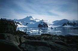 View of Pourquoi Pas Island from Horseshoe Island | |
 Pourquoi Pas Island Location in Antarctica | |
| Geography | |
|---|---|
| Location | Antarctica |
| Coordinates | 67°41′S 67°28′W |
| Length | 27 km (16.8 mi) |
| Width | 13 km (8.1 mi) |
| Administration | |
| Administered under the Antarctic Treaty System | |
| Demographics | |
| Population | Uninhabited |
See also
- Black Pass
- Quilp Rock an isolated rock 2.4 kilometres (1.3 nmi) off the northwest side of Pourquoi Pas Island
- Composite Antarctic Gazetteer
- List of Antarctic and sub-Antarctic islands
- List of Antarctic islands south of 60° S
- Mount Arronax
- SCAR
- Territorial claims in Antarctica
References
External links
![]()
![]()
This article is issued from Wikipedia. The text is licensed under Creative Commons - Attribution - Sharealike. Additional terms may apply for the media files.