Potton Brook
Potton Brook rises east of Gamlingay, Cambridgeshire, and flows southwest and then south through Potton[1] and the John O'Gaunt Golf Club and into Sutton, Bedfordshire. Potton Brook curves west and northwest, and joins the River Ivel northeast of Lower Caldecote.
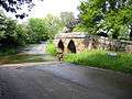 A packhorse bridge and ford across Potton Brook at Sutton in Bedfordshire
| Potton Brook | |
|---|---|
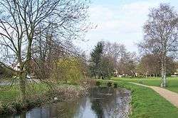 Potton Brook in Potton Park, Potton | |
| Location | |
| Country | England |
| Unitary Authority | Central Bedfordshire |
| Physical characteristics | |
| Source | |
| ⁃ location | east of Gamlingay, Cambridgeshire, England |
| ⁃ coordinates | 52°9′5.13″N 0°9′39.54″W |
| Mouth | |
⁃ location | Bedfordshire, England |
⁃ coordinates | 52°6′48″N 0°16′37″W |
⁃ elevation | 25 m (82 ft) |
| Discharge | |
| ⁃ location | Sandy |
References
- "Potton-Sutton Circular Walk". Ivel Countryside project and Befordshire County Council. Retrieved 4 January 2017.
| Unitary authorities | |
|---|---|
| Major settlements | |
| Topics |
|
This article is issued from Wikipedia. The text is licensed under Creative Commons - Attribution - Sharealike. Additional terms may apply for the media files.