Portjengrat
The Portjengrat (also known as Pizzo d'Andolla) is a mountain of the Pennine Alps, located on the border between Switzerland and Italy. It lies south of the Weissmies and the Zwischbergen Pass, where the international border diverges away from the main Alpine watershed. The summit of the Portjengrat has an elevation of 3,654 metres above sea level and is the tripoint between the valleys of Saas, Divedro (both in Valais) and Antrona (in Piedmont). It is the culminating point of the Antrona valley.
| Portjengrat | |
|---|---|
| Pizzo d'Andolla | |
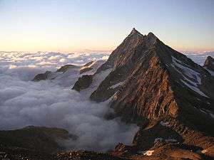 View from the south ridge of the Weissmies | |
| Highest point | |
| Elevation | 3,654 m (11,988 ft) |
| Prominence | 411 m (1,348 ft) [1] |
| Parent peak | Weissmies |
| Coordinates | 46°06′03.4″N 8°02′05″E |
| Geography | |
 Portjengrat Location in the Alps | |
| Location | Valais, Switzerland Piedmont, Italy |
| Parent range | Pennine Alps |
| Climbing | |
| First ascent | 7 September 1871 by Franz and Alexander Burgener guiding Clinton Thomas Dent |
The east side of the Portjengrat is covered by a glacier named Zwischbergen Gletscher. Smaller glaciers can be found on the west and south side of the mountain.
The closest locality is Saas-Almagell, on the west side.
See also
References
- Retrieved from the Swisstopo topographic maps. The key col is located south of the Zwischbergen Pass at 3,243 metres.
This article is issued from Wikipedia. The text is licensed under Creative Commons - Attribution - Sharealike. Additional terms may apply for the media files.