Ponte della Magliana
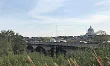
The Ponte della Magliana is a motorway bridge located in Rome. It crosses the Tiber between Pian due Torri (right bank) and Via del Cappellaccio (left bank), linking the Portuense and Ostiense quartieri, respectively on the right and left of the river.[1] Designed in 1930 and built to be the entrance on the west side of the new EUR district, it was completed only after the war.
Ponte della Magliana | |
|---|---|
 | |
| Coordinates | 41°50′22″N 12°27′29″E |
| Crosses | River Tiber |
| Locale | Rome, Ostiense and Portuense districts, Italy |
| Characteristics | |
| Material | Reinforced concrete, travertine |
| Total length | 223.62 m (733.7 ft) |
| Width | 19.25 m (63.2 ft) |
| History | |
| Designer | Romolo Raffaelli |
| Construction start | 1930 |
| Construction end | 1948 |
| Opened | 1948 |

| |
He is currently part of a larger viaduct which on the right bank of the Tiber continues towards the Colli Portuensi and the highway to the airport of Fiumicino and on the left towards the EUR, the Tre Fontane and Via Laurentina.
Description
Designed by Romolo Raffaelli, the bridge was built between 1930 and 1948; the construction was slowed down during the Second World War, because of the German army which destroyed the bridge centrings. The bridge is named after the zone where it is located, called Magliana. It connects Via della Magliana with Via Cristoforo Colombo.
It has seven arches in reinforced concrete covered with travertine and has a length of about 223 meters.
In 2018, it has been described by civil engineers to suffer "serious structural flaws and risks falling down"[2]
References
- Rendina (2005), p. 685
- Rome bridge risks collapsing
Sources
- Rendina, Claudio (2005). Enciclopedia di Roma. Roma: Newton Compton Editori. ISBN 88-541-0304-7.