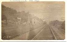
Plimptonville station
Plimptonville is an MBTA Commuter Rail station in Walpole, Massachusetts. It is located near the Neponset River next to a small dirt parking lot between Plimpton Street and the tracks. It is a flag stop on the Franklin Line, and receives the least service of any MBTA station, with just one round trip per day, consisting of an inbound morning train and an outbound evening train at the height of rush hour. Ridership on that round trip averaged just 12 passengers daily by a 2018 count.[1] Plimptonville has one of the smallest station facilities on the MBTA Commuter Rail system: an approximately 10-foot (3.0 m)-wide low-level asphalt platform next to the single track, with a small gravel parking lot.[2]
Plimptonville | |||||||||||||
|---|---|---|---|---|---|---|---|---|---|---|---|---|---|
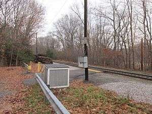 Bare platform at Plimptonville station in December 2012 | |||||||||||||
| Location | 185 Plimpton Street, Walpole, Massachusetts | ||||||||||||
| Coordinates | 42°09′32″N 71°14′10″W | ||||||||||||
| Line(s) | Franklin Branch | ||||||||||||
| Platforms | 1 low-level side platform | ||||||||||||
| Tracks | 1 | ||||||||||||
| Construction | |||||||||||||
| Parking | Several spaces (free) | ||||||||||||
| Other information | |||||||||||||
| Fare zone | 4 | ||||||||||||
| History | |||||||||||||
| Opened | April 23, 1849 | ||||||||||||
| Previous names | Tilton(s), Tiltonville, Plymptons | ||||||||||||
| Traffic | |||||||||||||
| Passengers (2018) | 12 (weekday average boardings)[1] | ||||||||||||
| Services | |||||||||||||
| |||||||||||||
| |||||||||||||
History
The Norfolk County Railroad was built through East Walpole beginning in 1846; it opened on April 23, 1849.[3][4][5] Three stops were located in Walpole: West Walpole, Walpole, and Plimptonville (also called Plymptons) adjacent to the Plimpton Iron Works near East Walpole.[4][5] After several reorganizations and mergers, the line became part of the New York and New England Railroad (NY&NE) in 1873.[3]
The station was renamed to Tiltons (also listed as Tilton and Tiltonville) by the 1870s after the mill village changed names.[6][7] A small wooden station building was located on the northwest side of the tracks.[8] The NY&NE was leased by the New Haven Railroad in 1898.[3] By the early 20th century, the name had reverted to Plimptonville.[9] The station's most famous user was Joseph N. Welch, who lived in Walpole while working at a Boston law firm and served as special counsel to the Army during the Army-McCarthy hearings.
The 1964-formed MBTA began subsidizing service on the route on April 24, 1966; it became the Franklin Line of the MBTA Commuter Rail system.[3] The station has become less important under public ownership due to its lack of parking, rural location, and proximity to the well-used Walpole station. Additionally, the station is in the middle of a single-track section of the line, severely limiting the number of trains that can stop. The MBTA closed the stop on February 1, 1981 due to budget cuts, but soon reopened it due to protests by riders.[10] The single round-trip serves a small but dedicated contingent of riders.[2] A planned project to double-track the line through the station was announced in November 2019.[11]
An unrelated station, also named Plympton, was located on the Old Colony Railroad's main line at Lake Street in Plympton, Massachusetts.[12]
References
- Central Transportation Planning Staff (2019). "2018 Commuter Rail Counts". Massachusetts Bay Transportation Authority.
- Homan, Nate (December 12, 2018). "The Track Least Traveled". DigBoston.
- Humphrey, Thomas J.; Clark, Norton D. (1985). Boston's Commuter Rail: The First 150 Years. Boston Street Railway Association. pp. 43–46. ISBN 9780685412947.
- Karr, Ronald Dale (1995). The Rail Lines of Southern New England. Branch Line Press. pp. 291–293. ISBN 0942147022.
- Broomer, Kathleen Kelly (February 2016). "National Register of Historic Places Registration Form" (PDF). National Register of Historic Places. National Park Service.
- Walpole. Atlas of Norfolk County, Mass. Comstock & Cline. 1876 – via Ward Maps.
- Atlas Plate No. 15. Topographical Atlas of Massachusetts. =Walker Lithograph & Publishing Co. 1891 – via Ward Maps.
- East Walpole. Atlas of Norfolk County. E. Robinson. 1888 – via Ward Maps.
- Atlas Plate No. 15. Atlas of Massachusetts. Geo. H. Walker & Co. 1904 – via Ward Maps.
- "Protestor stops Walpole line MBTA train". Boston Globe. February 3, 1981. p. 17 – via Newspapers.com.

- "FMCB Approves Franklin Line Double Track Phase 2 Work and Phase 3 Preliminary Design Work" (Press release). Massachusetts Bay Transportation Authority. November 18, 2019.
- Geo. H. Walker & Co. (1901). "Map of Brockton & Plymouth Street Railway". WardMaps LLC. Retrieved 8 December 2012.
External links
![]()