Placy-Montaigu
Placy-Montaigu is a former commune in the Manche department in Normandy in north-western France. On 1 January 2017, it was merged into the new commune Saint-Amand-Villages.[1]
Placy-Montaigu | |
|---|---|
Part of Saint-Amand-Villages | |
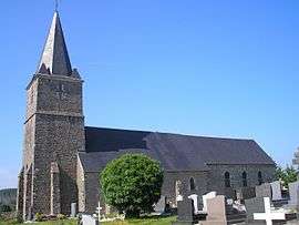 The church of Saint-Nicolas | |
Location of Placy-Montaigu 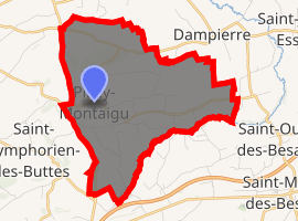
| |
 Placy-Montaigu  Placy-Montaigu | |
| Coordinates: 49°01′52″N 0°54′17″W | |
| Country | France |
| Region | Normandy |
| Department | Manche |
| Arrondissement | Saint-Lô |
| Canton | Condé-sur-Vire |
| Commune | Saint-Amand-Villages |
| Area 1 | 8.99 km2 (3.47 sq mi) |
| Population (2006) | 191 |
| • Density | 21/km2 (55/sq mi) |
| Time zone | UTC+01:00 (CET) |
| • Summer (DST) | UTC+02:00 (CEST) |
| Postal code | 50160 |
| Elevation | 109–228 m (358–748 ft) (avg. 170 m or 560 ft) |
| 1 French Land Register data, which excludes lakes, ponds, glaciers > 1 km2 (0.386 sq mi or 247 acres) and river estuaries. | |
See also
References
- Arrêté préfectoral 22 July 2016 (in French)
| Wikimedia Commons has media related to Placy-Montaigu. |
| Authority control |
|
|---|
This article is issued from Wikipedia. The text is licensed under Creative Commons - Attribution - Sharealike. Additional terms may apply for the media files.