Picture Rock Pass
Picture Rock Pass, elevation 4,830 feet (1,470 m), is a mountain pass in Oregon traversed by Oregon Route 31. It is located between the communities of Silver Lake and Paisley in Lake County. Geographically, it separates Silver Lake and Summer Lake.[1] These two lakes with their related drainage basins are the most northwesterly part of the Great Basin.[2]
| Picture Rock Pass | |
|---|---|
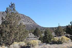 North side of Picture Rock Pass | |
| Elevation | 4,830 ft (1,472 m)[1] |
| Traversed by | |
| Location | Lake County, Oregon, United States |
| Coordinates | 43.047816°N 120.798798°W |
The name of the pass comes from petroglyphs on rocks south of the highway at the Picture Rock Pass Petroglyphs Site.[1]
References
- McArthur, Lewis A.; McArthur, Lewis L. (2003) [1928]. Oregon Geographic Names (7th ed.). Portland, Oregon: Oregon Historical Society Press. p. 761. ISBN 978-0875952772.
- "Southeast Oregon Basin and Range". SummitPost.org. Retrieved December 8, 2014.
This article is issued from Wikipedia. The text is licensed under Creative Commons - Attribution - Sharealike. Additional terms may apply for the media files.