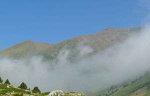
Pic de Finestrelles
Pic de Finestrelles is a mountain located in the Oriental Pyrenees, in the area bordering the states of France and Spain, in concret in Catalonia. It has an altitude of 2,826 metres (9,272 ft) above sea level.[1]
| Pic de Finestrelles | |
|---|---|
 | |
| Highest point | |
| Elevation | 2,826 m (9,272 ft) |
| Coordinates | 42°24′52.03″N 2°08′0.726″E |
| Geography | |
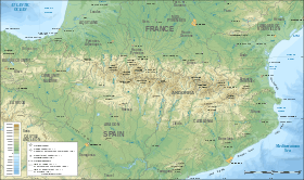 Pic de Finestrelles Location in the Pyrenees | |
| Location | Queralbs (Ripollès) Eina and Llo (Alta Cerdanya), Catalonia |
| Parent range | Pyrenees |
| Climbing | |
| First ascent | Unknown |
| Easiest route | From Ulldeter or Vall de Núria |
This peak is notable that is the mountain from which the world record for most distant landscape on Earth was taken. In particular the Massif of Ecrins (French Alps). The mountains were photographed at dawn by Marc Bret on July 16, 2016, covering a distance of 443 km to the Gaspard Peak. Bret utilised a Panasonic Lumix FZ72 with 1200mm zoom
See also
References
- "Mapa Topogràfic de Catalunya". Institut Cartogràfic de Catalunya. Retrieved May 22, 2010..
This article is issued from Wikipedia. The text is licensed under Creative Commons - Attribution - Sharealike. Additional terms may apply for the media files.