Petermann Ranges (Antarctica)
Not to be confused with the Petermann Orogeny in Central Australia
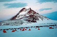
The fieldcamp of the GeoMaud expedition 1995/96 in the northern Petermann Chains, Antarctica
The Petermann Ranges (German: Petermannketten) are a number of associated mountain ranges including the Östliche Petermann, Mittlere Petermann, Westliche Petermann, Südliche Petermann, and Pieck Ranges, located just east of the Humboldt Mountains in the central Wohlthat Mountains of Queen Maud Land.
These mountain ranges were discovered and plotted from air photos by the Third German Antarctic Expedition (1938–1939), led by Capt. Alfred Ritscher, who named it for August Petermann.[1]
Geographical features
| Name | Peak elevation |
|---|---|
| Astor Rocks | |
| Graben Horn | 2,815m |
| Humboldt Graben | |
| Mount Skeidskneet | 2,600m |
| Skeidshornet Peak | 2,725m |
| Sørhortane | |
| Vestbanen Moraine | |
| Zwiesel Mountain | 2,970m |
References
- "Petermann Ranges". Geographic Names Information System. United States Geological Survey. Retrieved 2016-02-06.
![]()
This article is issued from Wikipedia. The text is licensed under Creative Commons - Attribution - Sharealike. Additional terms may apply for the media files.