Pennsylvania Route 973
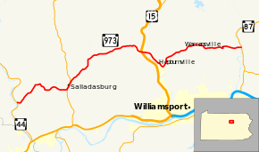
Pennsylvania Route 973 (PA 973) is a highway which runs for 27.3 miles (43.9 km), generally east–west in Lycoming County in north central Pennsylvania in the United States. Its western terminus is on the east bank of Pine Creek at Pennsylvania Route 44 in the unincorporated village of Tomb (or Tombs Run) in Watson Township, and its eastern terminus is at the hamlet of Loyalsockville in Upper Fairfield Township at Pennsylvania Route 87.
| ||||
|---|---|---|---|---|
 | ||||
| Route information | ||||
| Maintained by PennDOT | ||||
| Length | 27.3 mi[1] (43.9 km) | |||
| Major junctions | ||||
| West end | ||||
| East end | ||||
| Location | ||||
| Counties | Lycoming | |||
| Highway system | ||||
| ||||

Route description
Starting at its western end in Tomb, PA 973 runs east along Tombs Run, then northeast along the North Fork of Tombs Run. It then heads east into Mifflin Township, following Mud Run and the First Fork of Larrys Creek before crossing Larrys Creek and Pennsylvania Route 287, and turning north into the borough of Salladasburg. It follows Larrys Creek northeast into Anthony Township, where it leaves Larrys Creek and follows Stoney Gap Run into Lycoming Township.
There Route 973 follows Hoaglands Run east through the village of Quiggleville and hamlet of Perryville, passing a single offramp from southbound US 15 and overpasses carrying US 15 before crossing Lycoming Creek into Hepburn Township. Following Lycoming Creek southeast, Route 973 passes through the villages of Cogan Station and Hepburnville, then turns northeast to follow Mill Creek to the hamlet of Balls Mills, and on into Eldred Township. There it passes through the village of Warrensville, then the Loyalsock State Game Farm, and crosses Loyalsock Creek just before it meets PA 87 at Loyalsockville and its eastern end.
History
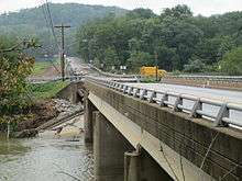
On September 8, 2011 the bridge at the eastern end of the highway over Loyalsock Creek (known as the Slabtown Bridge) was destroyed by flooding. Heavy rain from the remnants of Tropical Storm Lee raised the creek "higher than anything we've seen in recorded history", according to a Lycoming County official. The western portion of the bridge collapsed.[2] A replacement bridge was completed in November 2012 at a cost of $3 million.[3]
Major intersections
The entire route is in Lycoming County.
| Location | mi[1] | km | Destinations | Notes | |
|---|---|---|---|---|---|
| Watson Township | 0.0 | 0.0 | |||
| Mifflin Township | 6.2 | 10.0 | West end of PA 287 concurrency | ||
| 6.3 | 10.1 | East end of PA 287 concurrency | |||
| Lycoming Township | 15.8 | 25.4 | US 15 exit 143, exit from US 15 southbound to PA 973 only | ||
| Upper Fairfield Township | 27.3 | 43.9 | |||
1.000 mi = 1.609 km; 1.000 km = 0.621 mi
| |||||
See also


References
- Google (May 18, 2013). "Pennsylvania Route 973" (Map). Google Maps. Google. Retrieved May 18, 2013.
- Thompson, David (September 9, 2011). "'Worse than Agnes': Record flooding wreaks destruction". Williamsport Sun-Gazette. p. 1. Retrieved September 9, 2011.
- "PennDOT wrapping up another warm-weather construction season" (Press release). PennDOT. December 18, 2012. Retrieved May 18, 2013.
External links
| Wikimedia Commons has media related to Pennsylvania Route 973. |