Peak District Boundary Walk
The Peak District Boundary Walk is a circular 190-mile (310 km) walking trail, starting and finishing at Buxton and broadly following the boundary of the Peak District, Britain's first national park. The route was developed by the Friends of the Peak District (a branch of the Campaign to Protect Rural England) and was launched on 17 June 2017.[1]
The Friends of the Peak District's founders, Gerald and Ethel Haythornthwaite, proposed the boundary of the Peak District National Park, which was subsequently established as the United Kingdom's first National Park in 1951.

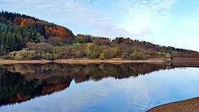
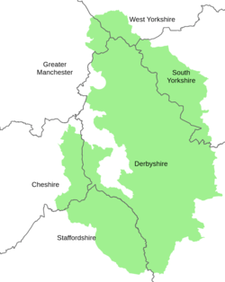
The route is waymarked with green markers and uses existing footpaths, tracks, quiet lanes, disused railway lines and a canal towpath. The terrain covers open moorlands of the South Pennines, the limestone scenery of the Derbyshire Dales, woodlands, reservoirs and rural farming countryside. Most of the trail is in Derbyshire but also goes through sections of Staffordshire, Cheshire and Yorkshire. The total ascent is 7,590 metres (24,900 ft) with a highest point of 506 metres (1,660 ft) at the summit of Shutlingsloe.[2]


There is an official guide to the trail written by Andrew McCloy.[3]
References
- "Boundary Walk". Friends of the Peak District. 12 October 2017. Retrieved 9 March 2020.
- "Peak District Boundary Walk". Long Distance Walkers Association. Retrieved 9 March 2020.
- McCloy, Andrew (2017). Peak District Boundary Walk: 190 Miles Around the Edge of the National Park. Friends of the Peak District. ISBN 978-1909461536.