Parish of Molonglo
Molonglo Parish, New South Wales is a civil parish of Murray County.[1][2]
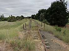
The abandoned Captains Flat railway line in Hoskinstown
The parish is located at 35°24′54″S 149°29′04″E, on the Molongolo River upstream from Queanbeyan. It includes Hoskinstown and Forbes Creek.
References
- Robert McLean, The New atlas of Australia : the complete work containing over one hundred maps and full descriptive geography of New South Wales, Victoria, Queensland, South Australia and Western Australia, together with numerous illustrations and copious indices (Sydney :J. Sands, [1886) Map 11.
- "Molonglo Parish". Geographical Names Register (GNR) of NSW. Geographical Names Board of New South Wales. Retrieved 17 April 2018.

This article is issued from Wikipedia. The text is licensed under Creative Commons - Attribution - Sharealike. Additional terms may apply for the media files.