Parish of Koonyaboothie
Koonyaboothie, New South Wales located at 29°36′59″S 142°23′17″E between Pindera Downs Aboriginal Area and Tibooburra, New South Wales is a cadastral parish of Tongowoko County New South Wales.[1]
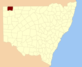
Tongowoko NSW.
The Geography, of the parish is mostly the flat, arid landscape of the Channel Country. The parish has a Köppen climate classification of BWh (Hot desert)[2].
The nearest town is Tibooburra
References
- "Tongowoko". Geographical Names Register (GNR) of NSW. Geographical Names Board of New South Wales. Retrieved 4 August 2013.

- Peel, M. C.; Finlayson, B. L.; McMahon, T. A. (2007). "Updated world map of the Köppen–Geiger climate classification". Hydrol. Earth Syst. Sci. 11: 1633–1644. doi:10.5194/hess-11-1633-2007. ISSN 1027-5606. (direct: Final Revised Paper)
.
This article is issued from Wikipedia. The text is licensed under Creative Commons - Attribution - Sharealike. Additional terms may apply for the media files.