Papenteich
Papenteich is a Samtgemeinde in the district of Gifhorn in Lower Saxony, Germany, situated approximately 10 km south of Gifhorn, and 15 km north of Braunschweig. Papenteich was founded on October 2, 1970 and includes 6 local municipalities with 19 villages. At present its population is 23,458.
Papenteich | |
|---|---|
 Coat of arms | |
Location of Papenteich 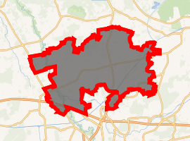
| |
 Papenteich  Papenteich | |
| Coordinates: 52°23′00″N 10°32′00″E | |
| Country | Germany |
| State | Lower Saxony |
| District | Gifhorn |
| Subdivisions | 6 municipalities |
| Government | |
| • Mayor | Helmuth Holzapfel (SPD) |
| Area | |
| • Total | 110.84 km2 (42.80 sq mi) |
| Elevation | 79 m (259 ft) |
| Population (2018-12-31)[1] | |
| • Total | 24,512 |
| • Density | 220/km2 (570/sq mi) |
| Time zone | CET/CEST (UTC+1/+2) |
| Vehicle registration | GF |
| Website | www.papenteich.de |
Geography
Structure
Papenteich was founded with eighteen member municipalities. With the reform of 1974, five municipalities with eighteen villages were constructed. The last reform was in 1981 with the integration of the village of Didderse as the sixth municipality. The administration of Papenteich is situated in the central village of Meine.
Neighbourhood
| Meinersen | Gifhorn | Isenbüttel |
| Peine |  |
Wolfsburg |
| Braunschweig | Helmstedt |
Structure of Papenteich
| Structure of the Samtgemeinde | ||||
|---|---|---|---|---|
| Municipality | Inhabitants (31. Dez 2003) | Surface: in km2 | Population density in inhabitants/km2 | Villages |
| Municipality Adenbüttel | 1 724 | 13,71 | 126 | Adenbüttel, Rolfsbüttel |
| Municipality Didderse | 1 404 | 7,41 | 189 | Didderse |
| Municipality Meine | 8 070 | 38,73 | 207 | Abbesbüttel, Bechtsbüttel, Grassel, Gravenhorst, Meine, Meinholz, Martinsbüttel, Ohnhorst, Wedelheine, Wedesbüttel |
| Municipality Rötgesbüttel | 2 280 | 10,83 | 211 | Rötgesbüttel |
| Municipality Schwülper | 6 627 | 20,89 | 317 | Hülperode, Klein Schwülper, Lagesbüttel, Rothemühle, Groß Schwülper, Walle |
| Municipality Vordorf | 3 326 | 19,26 | 173 | Eickhorst, Rethen, Vordorf |
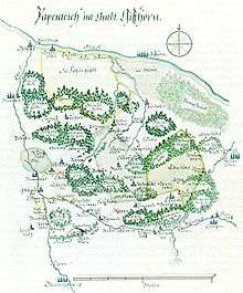 Map of the area Papenteich around the year 1600
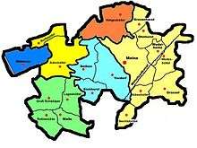 Structure of the Samtgemeinde Papenteich
| Wikimedia Commons has media related to Gifhorn/Papenteich. |
References
| Authority control |
|
|---|
This article is issued from Wikipedia. The text is licensed under Creative Commons - Attribution - Sharealike. Additional terms may apply for the media files.