Pantanos de Centla
The Centla swamps (Spanish: Pantanos de Centla) is a tropical moist forest ecoregion in southern Mexico, which includes seasonally flooded forests and wetlands, in the summer.
| Designations | |
|---|---|
| Official name | Reserva de la Biosfera Pantanos de Centla |
| Designated | 22 June 1995 |
| Reference no. | 733[1] |


Setting
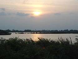
The ecoregion covers an area of 17,200 square kilometers (6,600 sq mi) in the states of Tabasco and Campeche. The Centla swamps occupy the delta of the Usumacinta and Grijalva rivers, which empty into the Gulf of Mexico and the Laguna de Términos through numerous distributaries. The ecoregion includes year-round wetlands, and freshwater swamp forests which are inundated during the summer rainy season.
The Usumacinta mangroves lie in the brackish-water zone between the Centla swamps and the open water of the Laguna de Términos and the Gulf. The Petén-Veracruz moist forests lie to the west and south, and the Yucatan moist forests lie to the east.
Flora
most of the flora is based on algae.
Fauna
Two of the most famous animals in Centla are the Morelet crocodile (Crocodylus moreleti) and the alligator gar, known as pejelagarto, a fish that already existed during the age of dinosaurs.
Conservation and threats
The Centla swamps were declared a Biosphere reserve in 2006.
References
- "Reserva de la Biosfera Pantanos de Centla". Ramsar Sites Information Service. Retrieved 25 April 2018.
External links
- World Wildlife Fund, ed. (2001). "Pantanos de Centla". WildWorld Ecoregion Profile. National Geographic Society. Archived from the original on 2010-03-08.
- "Pantanos de Centla". Terrestrial Ecoregions. World Wildlife Fund.
- Conservation Plan for the Pantanos de Centla Biosphere Reserve and Laguna de Términos Flora and Fauna Protection Area