Palpana
Palpana (from pparpana, ram[3]) is a volcano in the Andes of Chile. It has a summit elevation of 6,040 metres above sea level and is part of the dividing range between Upper Loa River basin and Salar de Ascotán basin. Together with Inacaliri and Azufre, it forms a 50 kilometres (31 mi) long volcanic chain constructed along the Inacaliri lineament.[4] The volcano rises above an ignimbrite plain that in the area reaches an altitude of 3,700 metres (12,100 ft).[5]
| Palpana | |
|---|---|
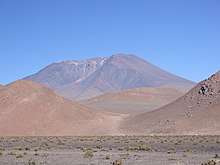
.jpg) The volcano is visible in the upper center portion of the photo, which was taken from the summit of Ollagüe volcano. Salar de Ascotán (left) and Salar de Carcote (right) are also visible in the photo. | |
| Highest point | |
| Elevation | 6,040 or 6,023 m (19,816 or 19,760 ft) [1][2] |
| Prominence | 1,947 m (6,388 ft) [1] |
| Listing | Ultra |
| Coordinates | 21°32′48″S 68°31′21″W [1] |
| Geography | |
 Palpana | |
| Parent range | Andes |
A lava dome cluster is recognizable in the central sector of the volcano, forming a flat area with a surface of 4.7 square kilometres (1.8 sq mi). The volcano contains basaltic rocks with an extrusion formed from more silicic rock. Layers of mafic andesite, scoria and some pumice extend outwards away from the central sector. The volcano rises 6,023 metres (19,760 ft) above its terrain and its average summit slope is 26°. The western flank underwent a collapse, leaving a 2.9 kilometres (1.8 mi) wide and 5.9 kilometres (3.7 mi) long scar and a deposit at the volcano's foot. Olivine and plagioclase phenocrysts are found in the andesites, the overall SiO2 content is 57.6-58.9% in samples from the southern ridge.[2][5][6][7] The volcano probably formed in a short timespan, given the mountainous composition and form.[8]
The volcano is no more than 1-2 mya old, but there is no evidence of postglacial material and erosion has carved radial ridges into the volcano.[2] Precise dating methods performed on the southeastern flank have found ages of 3.65±0.15 mya and 3.81±0.30 for lavas and scoria.[8] The snowline altitude in the area is 5,900–6,000 metres (19,400–19,700 ft)[9] Four moraine stages are found on the mountain, with the lowest moraines on the southern flank at 4,200 metres (13,800 ft) altitude.[5] Nowadays, block glaciers have been identified in the area,[10] one of which is found at 5,300 metres (17,400 ft).[5] The mountain is also one of the headwaters of the Loa River,[11] and water was transferred from Palpana to Antofagasta by pipeline.[12] A minor vegetation cover of 20-25% of the surface is present.[5]
The mountain is worshipped by pastoralist people who inhabit the surrounding land, and remnants of a sanctuary have been found on its summit.[13]
See also
References
- "Argentina and Chile: North Ultra-Prominences" Peaklist.org. In the footnotes, Peaklist offers this comment: Cerro Palpana: We believe this is marginally higher than the published 6023 meter elevation. Retrieved 2012-04-19.
- Huxley, Michael (1969). The Geographical Magazine (42 ed.). Geographical Press, University of Michigan. p. 802. Retrieved 1 December 2015.
- Latorre, Guillermo (1997). "Tendencias generales en la toponimia del Norte Grande de Chile" (PDF). Revista Onomázein (in Spanish). 2: 181–196. Retrieved 1 December 2015.
- de Silva, Shanaka L.; Francis, Peter William (1 January 1991). Volcanoes of the Central Andes. Springer Science+Business Media. p. 71. ISBN 9783540537069. Retrieved 1 December 2015.
- Schröder, Hilmar (June 1999). "Vergleichende Periglazialmorphologie im Sommerregengebiet der Atacama". Erdkunde (in German). 53 (2): 119–135. doi:10.3112/erdkunde.1999.02.03. JSTOR 25647145.
- Francis, P. W.; Wells, G. L. (July 1988). "Landsat Thematic Mapper observations of debris avalanche deposits in the Central Andes". Bulletin of Volcanology. 50 (4): 258–278. doi:10.1007/BF01047488.
- Wigger, Klaus-Joachim Reutter, Ekkehard Scheuber, Peter J. (1994). "Large- and Fine-Scale Geochemical Variations Along the Andean Arc of Northern Chile (17.5°– 22°S)". Tectonics of the Southern Central Andes Structure and Evolution of an Active Continental Margin. Berlin, Heidelberg: Springer Berlin Heidelberg. pp. 83–84. doi:10.1007/978-3-642-77353-2_5. ISBN 978-3-642-77353-2.
- Wörner, Gerhard; Hammerschmidt, Konrad; Henjes-Kunst, Friedhelm; Lezaun, Judith; Wilke, Hans (December 2000). "Geochronology (40Ar/39Ar, K-Ar and He-exposure ages) of Cenozoic magmatic rocks from Northern Chile (18-22°S): implications for magmatism and tectonic evolution of the central Andes". Revista geológica de Chile. 27 (2). Retrieved 1 December 2015.
- Singh, Ram Bali (1 January 1992). Dynamics of mountain geosystems. New Delhi: Ashish Pub. House. p. 165. ISBN 9788170244721. Retrieved 1 December 2015.
- Schröder, Hilmar (2001). "Kommentar Zu Den Anmerkungen Von Bettina Jenny, Klaus Kammer Und Bruno Messerli (erdkunde 55, 2001, 288–289)". Erdkunde (in German). 55 (3): 289–291. doi:10.3112/erdkunde.2001.03.07. JSTOR 25647397.
- Billinghurst, Guillermo Eduardo (1893-01-01). La irrigación en Tarapacá (in Spanish). Imprenta y Librería Ercilla. p. 65.
- Rudolph, William E. (1951-01-01). "Chuquicamata Twenty Years Later". Geographical Review. 41 (1): 88–113. doi:10.2307/211310. JSTOR 211310.
- Ibacache D, Sebastián; Cantarutti R, Gabriel; Berenguer R, José; Salazar S, Diego (2016-08-01). "Adoratorios de altura y dominación incaica en el Alto Loa, norte de Chile". Intersecciones en Antropología. 17 (2): 173–186. ISSN 1850-373X.
External links
- "Palpana, Chile" on Peakbagger
- Gardeweg, M.; Selles, D.; Arcos, R.; Pino, H.; Camacho, J.; Spronhle, C.; Sanhueza, A.; Mont, A. "Volcanismo del Cenozoico tardío al este de Collahuasi, Región de Tarapacá, Chile" (PDF). biblioserver.sernageomin.cl (in Spanish). Santiago: SERNAGEOMIN. Archived from the original (PDF) on 1 December 2015. Retrieved 1 December 2015.