Palisade Canyon (Nevada)
Palisade Canyon is a canyon along the Humboldt River in northern Eureka County, Nevada, United States.[1]
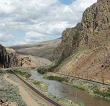
Description
The canyon runs along the Humboldt River roughly between State Route 278 upstream (about 7.5 miles [12.1 km] south–southwest of Carlin), and a point about 8 miles (13 km) west of Beowawe and State Route 306 downstream (about 32 miles [51 km] east–southeast of Battle Mountain).[2]
The Humboldt River, rather than flowing into the ocean, eventually loses all its water to evaporation in the Humboldt Sink, and stream-gage measurements undertaken by the United States Geological Survey suggest that Palisade Canyon is the point where the river's flow ceases to increase and begins to decrease.[3]
The canyon was named from a fancied resemblance to the Hudson River Palisades.[4]
References
- U.S. Geological Survey Geographic Names Information System: Palisade Canyon
- Google (May 27, 2020). "Palisade Canyon, Nevada 89821" (Map). Google Maps. Google. Retrieved May 27, 2020.
- Horton, Gary A. (2000). Humboldt River Chronology: an Overview (PDF). Carson City, Nev.: Nevada Division of Water Planning.
- Federal Writers' Project (1941). Origin of Place Names: Nevada (PDF). W.P.A. p. 35.