Palairos
Palairos (Greek: Πάλαιρος) is an ancient city and a modern town in Aetolia-Acarnania, Greece. Since the 2011 local government reform Palairos is part of the municipality Aktio-Vonitsa, of which it is a municipal unit.[2] The municipal unit has an area of 205.843 km2.[3] The municipal unit was formed as the independent municipality Kekropia in 1994 from the former communities Palairos and Pogonia, and was expanded with the former communities Vatos, Plagia and Peratia as a part of the 1997 Kapodistrias reform. The name was changed to Palairos in 2004.[4]
Palairos Πάλαιρος | |
|---|---|
 Palairos Location within the regional unit 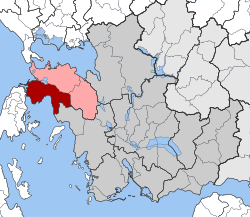 | |
| Coordinates: 38°48′N 20°53′E | |
| Country | Greece |
| Administrative region | West Greece |
| Regional unit | Aetolia-Acarnania |
| Municipality | Aktio-Vonitsa |
| • Municipal unit | 205.8 km2 (79.5 sq mi) |
| Elevation | 23 m (75 ft) |
| Population (2011)[1] | |
| • Municipal unit | 4,383 |
| • Municipal unit density | 21/km2 (55/sq mi) |
| Community | |
| • Population | 2,729 (2011) |
| Time zone | UTC+2 (EET) |
| • Summer (DST) | UTC+3 (EEST) |
History
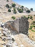
Palairos (Ancient Greek: Παλαιρός, Latin: Palaerus) was a city of ancient Greece, situated in the southern part of the region of Epirus.[5] The city, ruinous for centuries, is thought to have existed during the Mycenean period, since parts of the city walls appear to date back to 2000 B.C. The construction of the walls interchanges between the square-shaped and the polygonal system and the parts belong to different periods. It lies high in the mountains overlooking the Ionian sea and Lake Vourkaria. The city is thought to have had a population of over 10,000 people.
.svg.png)
During antiquity it was part of Acarnania, according to the Theodorokoi, situated on the west coast, on the Ionian Sea, which is placed by Strabo between Leucas and Alyzia.[6] In the first year of the Peloponnesian War (431 BCE) Palairos was in alliance with the Athenians; and when the latter people took the neighbouring town of Sollium, which was a Corinthian colony, they gave both it and its territory to the inhabitants of Palaerus.[7]
At nearby Actium, Mark Antony and Cleopatra were defeated in a sea battle by Octavius. According to tradition, the salt lake was the saviour of Cleopatra, who hid her ships there.
The citadel on the eastern part of the yard is separated by a partition and is considered to be the most ancient part of the wall, probably from the Mycenean period. The ruins are close to the present-day town of Palairos.
References
- "Απογραφή Πληθυσμού - Κατοικιών 2011. ΜΟΝΙΜΟΣ Πληθυσμός" (in Greek). Hellenic Statistical Authority.
- Kallikratis law Greece Ministry of Interior (in Greek)
- "Population & housing census 2001 (incl. area and average elevation)" (PDF) (in Greek). National Statistical Service of Greece.
- EETAA local government changes
- An Inventory of Archaic and Classical Poleis: An Investigation Conducted by The Copenhagen Polis Centre for the Danish National Research Foundation by Mogens Herman Hansen, 2005, page 368
- Strabo, x.
- Thucydides, II, 30.
![]()