Pakaraka
Pakaraka is a settlement in Northland, New Zealand, at the junction of State Highway 1 and 10, in the district the Ngāpuhi tribe called Tai-a-mai.[1]
Pakaraka | |
|---|---|
 Pakaraka | |
| Coordinates: 35°21′27″S 173°57′23″E | |
| Country | New Zealand |
| Region | Northland Region |
| District | Far North District |
Demographics
| Historical population | ||
|---|---|---|
| Year | Pop. | ±% p.a. |
| 2006 | 507 | — |
| 2013 | 555 | +1.30% |
| 2018 | 666 | +3.71% |
| Source: [2] | ||
Pakaraka and its surrounds had a population of 666 at the 2018 New Zealand census, an increase of 111 people (20.0%) since the 2013 census, and an increase of 159 people (31.4%) since the 2006 census. There were 222 households. There were 333 males and 333 females, giving a sex ratio of 1.0 males per female. Of the total population, 147 people (22.1%) were aged up to 15 years, 96 (14.4%) were 15 to 29, 333 (50.0%) were 30 to 64, and 93 (14.0%) were 65 or older. Figures may not add up to the total due to rounding.
Ethnicities were 80.2% European/Pākehā, 34.2% Māori, 0.9% Pacific peoples, 0.0% Asian, and 1.4% other ethnicities. People may identify with more than one ethnicity.
The percentage of people born overseas was 14.0, compared with 27.1% nationally.
Although some people objected to giving their religion, 55.4% had no religion, 32.0% were Christian, and 2.3% had other religions.
Of those at least 15 years old, 96 (18.5%) people had a bachelor or higher degree, and 90 (17.3%) people had no formal qualifications. The median income was $29,400. The employment status of those at least 15 was that 264 (50.9%) people were employed full-time, 84 (16.2%) were part-time, and 24 (4.6%) were unemployed.[2]
History and culture

Pre-European history
A pā was located at the base, and on the slopes, of Pouerua, a 270 metres (890 ft) high basaltic scoria cone. The pā was studied during a major archeological project in the 1980s.[3]
Parts of the Flagstaff War were fought around Pakaraka in 1845.[4] After the Battle of Ohaeawai on 23 June 1845 the British troops destroyed Te Haratua's pā at Pakaraka on 16 July 1845.[5]
Modern history
Mount Pouerua is registered with the Heritage New Zealand as a traditional site. Holy Trinity Church. The Retreat and the Store are also registered with the trust.[6]
Marae
The local Kahukura Ariki Marae and Kahukura Ariki meeting house are affiliated with the Ngāti Kahu ki Whangaroa hapū of Hāhi Katorika, and the Ngāpuhi / Ngāti Kahu ki Whaingaroa hapū of Ngāti Kohu.[7][8]
Education
Pakaraka School is a coeducational full primary (years 1-8) school with a roll of 52 students as of March 2020.[9][10] 60% of the students are Māori.[11]
Notable people
- Hone Heke, a Ngāpuhi chief, was born at Pakaraka in about 1807 or 1808.[12] He was buried here in secret in August 1850. In 2011 his remains were removed due to possible development of the land around the burial site.
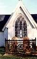
- The missionary Henry Williams retired to Pakaraka and built a church in 1850-51. The church that now stands on the site was opened on 27 November 1873,[13] the church was constructed by Williams' wife and family as a memorial to his life.[14] The church is named Holy Trinity Church as Trinity Sunday was the day on which Henry was ordained by the Bishop of London, and Trinity Sunday was also the last day that Henry and Marianne Williams spent at Paihia before moving to Pakaraka. They lived by the church in a house known as The Retreat, that still stands.[15]
- The first and third sons of the missionary Henry Williams, Edward & Henry farmed here.
Gallery
- Holy Trinity Church at Pakaraka
 Gravestones of Henry and Marianne Williams, Holy Trinity Church
 Interior of the Holy Trinity
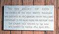 A plaque in the church
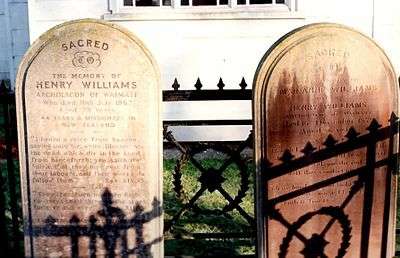 Gravestones of Henry and Marianne Williams
Notes
- Best, Elsdon (1927). "Old Forts of the Taiamai District, Bay of Islands". The Pa Maori. Whitcombe and Tombs Limited.
- "Statistical area 1 dataset for 2018 Census". Statistics New Zealand. March 2020. Pakaraka (103600). 2018 Census place summary: Pakaraka
- Doug G. Sutton; Louise Furey; Yvonne M. Marshall (2003). The archaeology of Pouerua. Auckland University Press. ISBN 1-86940-292-8.
- Reverend Robert Burrows (1886). "Extracts from a Diary during Heke's War in the North in 1845".
- Cowan, James (1922). "Volume I: 1845–1864". The New Zealand Wars: a history of the Maori campaigns and the pioneering period. Wellington: R.E. Owen. pp. 73–144.
- "New Zealand Heritage List/Rārangi Kōrero". Historic Places Trust. Retrieved 28 January 2015.
- "Te Kāhui Māngai directory". tkm.govt.nz. Te Puni Kōkiri.
- "Māori Maps". maorimaps.com. Te Potiki National Trust.
- "New Zealand Schools Directory". New Zealand Ministry of Education. Retrieved 26 April 2020.
- Education Counts: Pakarata School
- "Pakaraka School". Education Review Office. 1 March 2018.
- "Heke Pokai, Hone Wiremu". Dictionary of New Zealand Biography.
- "The Church Missionary Gleaner, May 1874". Opening of a new church in New Zealand. Adam Matthew Digital. Retrieved 24 October 2015.
- "Holy Trinity, Pakaraka, Northland". Don Donovan.
- "The Retreat (Pakaraka)". Henry and William Williams Memorial Museum Trust. Retrieved 28 January 2015.