Our (river)
The Our (Luxembourgish: [ˈuːə̯]; French: [uʁ], German: [ˈʔu:ɐ̯]) is a river in Belgium, Luxembourg and Germany. It is a left-hand tributary of the river Sauer/Sûre. Its total length is 78 kilometres (48 mi).
| Our | |
|---|---|
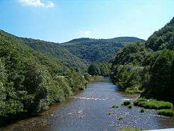 The Our flowing through the Ardennes in Luxembourg | |
.png) Course of the Our | |
| Location | |
| Countries | Belgium, Luxembourg, Germany |
| States | Rhineland-Palatinate |
| Reference no. | DE: 2626 |
| Physical characteristics | |
| Source | |
| ⁃ location | Northeast of the Eichelsberg in the municipality of Büllingen, parish of Manderfeld |
| ⁃ coordinates | 50°22′38″N 6°20′45″E |
| ⁃ elevation | ca. 643 m |
| Mouth | |
⁃ location | Near Wallendorf into the Sauer |
⁃ coordinates | 49°52′30″N 6°17′12″E |
⁃ elevation | ca. 177 m above sea level (NHN) |
| Length | 96.111 km (59.721 mi) [1] |
| Basin size | 668.334 km2 (258.045 sq mi) [1] |
| Discharge | |
| ⁃ location | at Gemünd Our gauge[2] |
| ⁃ average | 9.38 m3/s (331 cu ft/s) |
| ⁃ minimum | Record low: 50 l/s (1.8 cu ft/s) (in 05.07.1976) Average low: 545 l/s (19.2 cu ft/s) |
| ⁃ maximum | Average high: 118 m3/s (4,200 cu ft/s) Record high: 236 m3/s (8,300 cu ft/s) (in 22.12.1991) |
| Basin features | |
| Progression | Sauer→ Moselle→ Rhine→ North Sea |
The source of the Our is in the High Fens in southeastern Belgium, near Manderfeld. It flows southwards, more or less along the German-Belgian border, and after Ouren, along the German-Luxembourg border. The historic town of Vianden lies on the Our. The Our empties into the Sauer in Wallendorf.


Course
The river rises in the eastern Ardennes and western Eifel on Belgian soil. Its source near the village of Losheimergraben lies northeast of the Eichelsberg mountain (653 m) at 643 m near the B 265. Just a few hundred metres away is the source of the River Kyll. The Our initially follows the B 265, which is also the Belgian-German state border. The river continues alternating between Belgium and Germany. From the tripoint by the Europa Monument between Ouren (B), Sevenig (D) and Lieler (L) it runs almost entirely on the German-Luxembourg border until it reaches Wallendorf in Germany where it empties into the Sauer. It flows mainly from north to south but also meanders in places.
For the section where it runs along the German-Luxembourg border the Our is a jointly managed condominium (the "Joint German-Luxembourg Sovereign Area"). Unilateral sovereignty only begins at the respective shore. In its upper reaches between Germany and Belgium, the state border lies, as is normal on the thalweg of the river.
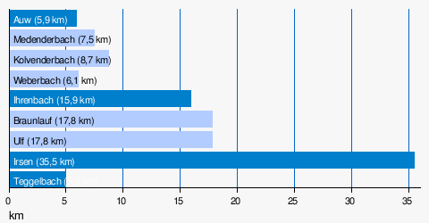
Tributaries
– Location of the confluences measured from the source of the Our –
- Auw (left, at km 9)
- Ihrenbach (left, at km 21)
- Braunlauf (right, at km 23)
- Irmisch (left, near km 26)
- Ulf (right, near km 30)
- Irsen (left, near km 67)
- Length of tributaries over 5 km
A comprehensive list that also includes the smaller tributaries is here.
Villages on the Our
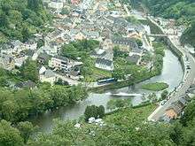
The border village of Vianden, one of the most important tourist resorts in Luxembourg, lies on the Our. The Our Valley Route is a circular route that runs through Belgium and North Luxembourg. Especially worth seeing is the section between Manderfeld (Belgium) and Lieler (Luxembourg), where the route follows the Our almost all the way. It runs inter alia past Reuland Castle (Ouren) and the Europa Monument at the German-Belgian-Luxembourg tripoint.
Other villages are:
- Roth an der Our
- Ouren
- Sevenig
- Dahnen
- Dasburg
- Rodershausen
- Obereisenbach
- Stolzembourg
- Bettel
- Gentingen
- Ammeldingen an der Our
- Schönberg
- Wallendorf near Bollendorf.
- Grüfflingen near St. Vith
- Auel (village in Burg-Reuland)
Usage
The Our is impounded north of Vianden by the Our Dam and forms the lower basin of the Vianden Pumped Storage Plant.
References
- Geoexplorer of the Rhineland-Palatinate Water Authority (Wasserwirtschaftsverwaltung Rheinland-Pfalz)
- Pegel Gemünd Our Daten des LfU Rheinland-Pfalz
Literature
- Leonard Palzkill: Ourtal ohne Grenzen. Neuerburg, 2006, ISBN 3-00-018095-8.
External links
| Wikimedia Commons has media related to Our River. |
- Ourtal-Route (pdf; 541 kB) at the Wayback Machine (archived February 16, 2012)
- Official home page of the Our Nature Park with information on tourism, the ecology and local events for North Luxembourg
- Project Nat'Our at the Wayback Machine (archived May 27, 2009)
- Ensebach - Upper Our Nature Reserve
- Hochwassermeldezentrum The Moselle in Trier
| Authority control |
|
|---|