Osceola Mudflow
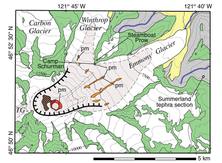
The Osceola Mudflow, also known as the Osceola Lahar, was a lahar in the U.S. state of Washington that descended from the summit and northeast slope of Mount Rainier during a period of eruptions about 5,600 years ago. It traveled down the west and main forks of the White River, passed the location of present-day Enumclaw then reached Puget Sound near present-day Auburn. The Osceola collapse formed a 1.8 km (1.1 mi) wide horseshoe-shaped crater, open to the northeast, almost the same size as the crater produced by the 1980 eruption of Mount St. Helens. Most of the Osceola crater has been filled in by subsequent lava eruptions, most recently about 2,200 years ago.[1]
With a volume of 2 to 3 km3 (0.48 to 0.72 cu mi) and an areal extent of about 550 km2 (210 sq mi), the Osceola Mudflow buried a large portion of the Puget Sound lowland with hydrothermally altered volcanic material. Many communities in King and Pierce counties, notably Kent, Enumclaw, Orting, Buckley, Sumner, Puyallup and Auburn, are wholly or partly located on top of Osceola Mudflow deposits.[1]
The Osceola Mudflow was Mount Rainier's signature event during the Holocene epoch.[1] It was named after the unincorporated community of Osceola.
References
![]()
- "Significant Lahars at Mount Rainier". United States Geological Survey. 2014-11-10. Retrieved 2018-03-18.