Ordu
Ordu (Turkish pronunciation: [ˈoɾdu]) or Altınordu is a port city on the East Black Sea coast of Turkey, historically also known as Cotyora or Kotyora (Greek: Κοτύωρα), and the capital of Ordu Province with a population of 217,640 in the city center.
Ordu | |
|---|---|
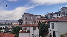
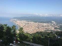 View of Ordu from Boztepe hill | |
 Ordu Location of Ordu within Turkey | |
| Coordinates: 40°59′N 37°53′E | |
| Country | Turkey |
| Region | Black Sea |
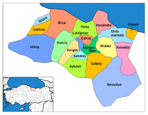
| Province | Ordu |
| Government | |
| • Mayor | Hilmi Güler (AKP) |
| Area | |
| • District | 303.55 km2 (117.20 sq mi) |
| Elevation | 5 m (16 ft) |
| Population (2019)[2] | |
| • Urban | 217,640 |
| • District | 742,341 |
| • District density | 2,400/km2 (6,300/sq mi) |
| Time zone | UTC+2 (EET) |
| • Summer (DST) | UTC+3 (EEST) |
| Postal code | 52xxx |
| Area code(s) | 0452 |
| Licence plate | 52 |
| Climate | Cfa |
History
In the 8th century BC, Cotyora (Κοτύωρα) was founded by the Miletians as one of a string of colonies along the Black Sea coast. The Diodorus Siculus write that it was a colony of the Sinopians.[3] Xenophon's Anabasis relates that the Ten Thousand rested there for 45 days before embarking for home.[4][5][6] Strabo also mentions it.[7] Under Pharnaces I of Pontus, Cotyora was united in a synoikismos with Cerasus.[4] Arrian, in the Periplus of the Euxine Sea (131 CE), describes it as a village "and not a large one."[8] Suda mentioned that it was also called Cytora (Κύτωρα).[9]
The area came under the control of the Danishmends, then the Seljuk Turks in 1214 and 1228, and the Hacıemiroğulları Beylik in 1346. Afterwards, it passed to the dominion of the Ottomans in 1461 along with the Empire of Trabzon.[10]
The modern city was founded by the Ottomans as Bayramlı near Eskipazar as a military outpost 5 km (3 mi) west of Ordu.
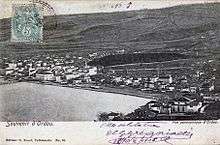
In 1869, the city's name was changed to Ordu and it was united with the districts of Bolaman, Perşembe, Ulubey, Hansamana (Gölköy), and Aybastı. At the turn of the 20th century, the city was more than half Christian (Greek and Armenian), and was known for its Greek schools.[6]
On 04 Nisan 1921, Ordu province was created by separating from Trebizond Vilayet.[11]
Archaeology
In 2016, archaeologist discovered a marble statue of Cybele. In 2018, at the same site, they also discovered sculptures of Pan and Dionysus.[12]
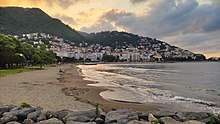
Ordu today
.jpg)
The Sağra factory shop, selling many varieties of chocolate-covered hazelnuts, is one of the town's attractions.
The Boztepe aerial tramway is another popular attraction which is set to become a modern symbol for the city.
Local music is typical of the Black Sea region, including the kemençe. The cuisine is primarily based on local vegetables and includes both typical Turkish dishes — such as pide and kebab — and more interesting fare such as plain or caramel 'burnt ice-cream'.
Economy
Ordu is famous for hazelnuts, producing about 25 percent of the worldwide crop. The province relies on the crop for up to 80% of its economic activity. Turkey as a whole produces about 75 percent of the world's hazelnuts.[13] As of 1920, Ordu was one of the few producers of white green beans, which were exported to Europe.[14] Ordu also had mulberry tree plantations for sericulture.[15] Today, the city is partially industrialized and a member of the Anatolian Tigers with its 7 companies.
Places of interest
- Paşaoğlu Konağı and Ethnographic museum – an ethnographic museum.
- Taşbaşı Cultural Centre – a cultural centre
- Boztepe – a hill of 550 m (1,800 ft) overlooking the town from the west. Since June 2012, an aerial lift system provides an easy way of transportation between the city's coastline and the hilltop. The Ordu Boztepe Gondola can transport hourly 900 passengers up to the hilltop in 6.5 minutes.[16][17]
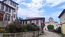
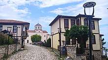
- Old Houses of Ordu in the old city center
- Yalı Camii, also called Aziziye Camii – a mosque
- Atik İbrahim Paşa Camii, also called Orta Cami – a mosque built in 1770
- Eski Pazar Camii – a mosque with adjoining Turkish baths
- Efirli Camii – a mosque
- Cape Jason is an Archaeological site and a small peninsula facing the sea. Its name is derived from the Mythological leader Jason of the Argonauts.
Sports
The city is the home of the Orduspor football club. Its base is the 19 Eylül Stadium in the heart of the city. Orduspor football team has played in the Super League of Turkey several seasons. The club also has a basketball team.
International relations
Climate
Ordu has a humid subtropical climate (Köppen climate classification: Cfa), like most of the eastern Black Sea coast of Turkey, with warm and humid summers and cool and damp winters. Ordu has a high and evenly distributed precipitation throughout the year. Precipitation is heaviest in autumn and spring.
Snowfall is quite common between the months of December and March, snowing for a week or two, and it can be heavy once it snows.
The water temperature, like in the rest of the Black Sea coast of Turkey, is always cool and fluctuates between 8 and 20 °C (46 and 68 °F) throughout the year.
| Climate data for Ordu (1959–2017) | |||||||||||||
|---|---|---|---|---|---|---|---|---|---|---|---|---|---|
| Month | Jan | Feb | Mar | Apr | May | Jun | Jul | Aug | Sep | Oct | Nov | Dec | Year |
| Record high °C (°F) | 25.4 (77.7) |
28.3 (82.9) |
32.8 (91.0) |
36.8 (98.2) |
35.8 (96.4) |
37.3 (99.1) |
37.1 (98.8) |
34.4 (93.9) |
36.4 (97.5) |
34.2 (93.6) |
32.4 (90.3) |
29.7 (85.5) |
37.3 (99.1) |
| Average high °C (°F) | 10.8 (51.4) |
10.9 (51.6) |
12.0 (53.6) |
15.2 (59.4) |
19.1 (66.4) |
24.0 (75.2) |
26.7 (80.1) |
27.3 (81.1) |
24.2 (75.6) |
20.1 (68.2) |
16.4 (61.5) |
12.9 (55.2) |
18.3 (64.9) |
| Daily mean °C (°F) | 6.8 (44.2) |
6.9 (44.4) |
8.1 (46.6) |
11.5 (52.7) |
15.8 (60.4) |
20.4 (68.7) |
23.0 (73.4) |
23.3 (73.9) |
20.0 (68.0) |
15.9 (60.6) |
11.9 (53.4) |
8.8 (47.8) |
14.4 (57.9) |
| Average low °C (°F) | 3.8 (38.8) |
3.8 (38.8) |
5.1 (41.2) |
8.2 (46.8) |
12.4 (54.3) |
16.5 (61.7) |
19.4 (66.9) |
19.9 (67.8) |
16.7 (62.1) |
12.8 (55.0) |
8.6 (47.5) |
5.7 (42.3) |
11.1 (52.0) |
| Record low °C (°F) | −7.2 (19.0) |
−6.7 (19.9) |
−4.7 (23.5) |
−1.4 (29.5) |
3.4 (38.1) |
8.4 (47.1) |
12.6 (54.7) |
13.0 (55.4) |
8.2 (46.8) |
2.5 (36.5) |
−1.5 (29.3) |
−3.2 (26.2) |
−7.2 (19.0) |
| Average precipitation mm (inches) | 97.2 (3.83) |
78.9 (3.11) |
78.9 (3.11) |
68.8 (2.71) |
56.0 (2.20) |
75.1 (2.96) |
63.6 (2.50) |
67.7 (2.67) |
79.9 (3.15) |
131.9 (5.19) |
125.8 (4.95) |
113.9 (4.48) |
1,037.7 (40.85) |
| Average precipitation days | 14.0 | 13.7 | 15.3 | 14.5 | 13.4 | 11.1 | 9.6 | 9.7 | 11.8 | 14.2 | 13.0 | 14.4 | 154.7 |
| Mean monthly sunshine hours | 77.5 | 87.6 | 102.3 | 129.0 | 170.5 | 210.0 | 195.3 | 186.0 | 156.0 | 127.1 | 102.0 | 74.4 | 1,617.7 |
| Mean daily sunshine hours | 2.5 | 3.1 | 3.3 | 4.3 | 5.5 | 7.0 | 6.3 | 6.0 | 5.2 | 4.1 | 3.4 | 2.4 | 4.4 |
| Source: Turkish State Meteorological Service[20] | |||||||||||||
People from Ordu
- Gürbüz Doğan Ekşioğlu – Famous Turkish cartoonist and graphics designer
- Ertuğrul Günay – politician who is a former Minister for Culture and Tourism
- Kadir İnanır – film actor
- Mehmet Hilmi Güler – politician who was Minister of Energy and Natural Resources
- Arif Hikmet Onat – politician who represented Ordu
- Bahriye Üçok – writer and activist
- Oktay Ekşi – politician representing Ordu
- Ümit Tokcan – folk musician
- Kamil Sönmez – folk musician
- Soner Arıca – musician
- Ery Kehaya – Ottoman-Greek businessman founder and president of the Standard Commercial Tobacco Company[21]
References
- "Area of regions (including lakes), km²". Regional Statistics Database. Turkish Statistical Institute. 2002. Retrieved 5 March 2013.
- "Population of province/district centers and towns/villages by districts - 2012". Address Based Population Registration System (ABPRS) Database. Turkish Statistical Institute. Retrieved 27 February 2013.
- Diodorus Siculus, Library, § 14.31.1
- Olshausen, Eckart, "Cotyora" in Brill’s New Pauly, Antiquity doi:10.1163/1574-9347_bnp_e621460
- Anabasis V.5.3f
- Encyclopedia Britannica Eleventh Edition, s.v. Ordu
- XII.3.17
- 16.3 Translated in Arrian: Periplus Ponti Euxini, edited and translated by Aidan Liddle (London: Bristol Classical Press, 2003), p. 75
- Suda, ka.2170
- Dionysus, Pan sculptures found at site of 2,100-year-old goddess Kybele in northern Turkey
- Schwartzstein, Peter (22 August 2015). "This small Turkish town grows a quarter of the world's hazelnuts". Quartz. Retrieved 7 March 2020.
- Prothero, W.G. (1920). Armenia and Kurdistan. London: H.M. Stationery Office. p. 62.
- Prothero, W.G. (1920). Armenia and Kurdistan. London: H.M. Stationery Office. p. 64.
- "GD8 Ordu-Boztepe – References – Company – LEITNER ropeways". Leitner-ropeways.com. Retrieved 14 September 2016.
- "Tatilden dersler aldık". Erzurum Flaş (in Turkish). 27 August 2013. Archived from the original on 13 November 2013. Retrieved 13 November 2013.
- "Batumi – Twin Towns & Sister Cities". Batumi City Hall. Archived from the original on 4 May 2012. Retrieved 10 August 2013.
- "Twin-cities of Azerbaijan". Azerbaijans.com. Retrieved 9 August 2013.
- "Resmi İstatistikler: İllerimize Ait Genel İstatistik Verileri" (in Turkish). Turkish State Meteorological Service. Retrieved 22 January 2019.
- 25 May 1964, NY Times archives
External links
| Authority control |
|
|---|