Ordnance datum
In the British Isles, an ordnance datum or OD is a vertical datum used by an ordnance survey as the basis for deriving altitudes on maps. A spot height may be expressed as AOD for "above ordnance datum". Usually mean sea level (MSL) is used for the datum. In particular:
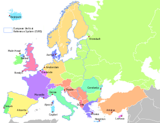
- In Great Britain, OD for the Ordnance Survey is ODN (Ordnance Datum Newlyn), defined as the MSL at Newlyn in Cornwall between 1915 and 1921. Prior to 1921, OD was taken from the level of the Victoria Dock, Liverpool (ODL). The difference between the different data varies across the country; full details are available from the Ordnance Survey website (below).
- In Northern Ireland, OD for the Ordnance Survey of Northern Ireland is Belfast Ordnance Datum, the MSL at Clarendon Dock, Belfast between 1951 and 1956.
- In the Republic of Ireland, OD for the Ordnance Survey of Ireland is Malin Ordnance Datum: the MSL at Portmoor Pier, Malin Head, County Donegal, between 1960 and 1969.[1]
- Prior to 1970, Poolbeg Ordnance Datum was used: the low water of spring tide at Poolbeg Lighthouse, Dublin, on 8 April 1837. Poolbeg OD was about 2.7 metres (9 feet) lower than Malin OD.[1]

Vertical references in Europe
Tunnel datum
Tunnel datum is a datum based on an ordnance datum and used in designing tunnels which pass below sea level.
- for the London Underground, a tunnel datum of ODN −100 m is used;[2] thus a depth of −60 m AOD is 40 m ATD (above tunnel datum)
- for the Channel Tunnel, a tunnel datum of ODN −200 m is used;[3] thus a depth of −60 m is 140 m ATD
References
- Irish Grid Reference System Archived 2008-06-14 at the Wayback Machine from OSI website
- "Victoria Station Upgrade Environmental Statement: Main Report" (PDF). Transport for London. 15 November 2007. pp. 2–6, §2.5.4, fn 2. Retrieved 28 July 2008.
- Radcliffe, Eric (1995). "Control and Construction Surveys". In Colin J Kirkland (ed.). Engineering the Channel Tunnel. Taylor & Francis. p. 53. ISBN 0-419-17920-8.
External links
This article is issued from Wikipedia. The text is licensed under Creative Commons - Attribution - Sharealike. Additional terms may apply for the media files.