Omokoroa
Omokoroa is a small urban area in the Western Bay of Plenty District of New Zealand. The suburb is considered part of Greater Tauranga (contributing towards its population of 135,000), and is within the Bay of Plenty electorate.[2] Omokoroa began as a small rural holiday village, but is expanding to be a commuter town, with a 25-minute drive to Tauranga City.
Omokoroa | |
|---|---|
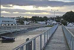 The sun setting at the Omokoroa wharf | |
 Omokoroa | |
| Coordinates: 37°40′00″S 176°01′58″E | |
| Country | |
| Region | Bay of Plenty |
| Territorial authority | Tauranga District |
| Ward | Kaimai |
| Population (June 2019)[1] | |
| • Total | 2,820 |
Omokoroa itself had a population of 2547 as of 2013, but is now nearer 3000 after being now designated as an area of special housing growth. It is expected to reach a population of 12,000 by 2020–2030, and is situated within the Kaimai Ward, Western Bay of Plenty. Omokoroa includes the urban area on the harbour side of State Highway 2, along with Youngson Road to Plummers Point Road, and parts of Old Highway Road.
Communication

The postcodes for the area are:
- 3114 - Railway line to harbour edge
- 3172 - Railway line towards SH2 [3]
The dialing prefix(es) for the town are
- (+64) 7 548
Education
Omokoroa School is a co-educational state primary school for Year 1 to 8 students,[4][5] with a roll of 275 as of March 2020.[6]
Omokoroa Point School is another co-educational state primary school for Year to 8 students,[7] with a roll of 284.[8]
The nearest zoned secondary schools in the area are Otumoetai College, Tauranga Boys' College and Tauranga Girls' College. Katikati College and the private Bethlehem College are also nearby.[9]
References
- "Subnational Population Estimates: At 30 June 2019". Statistics New Zealand. 22 October 2019. Retrieved 11 January 2020.
- "Electorate Boundaries". NZ Elections.
- Postcodes for the Western Bay of Plenty District
- "Omokoroa School Official School Website". omokoroa.school.nz.
- "Omokoroa School Ministry of Education School Profile". educationcounts.govt.nz. Ministry of Education.
- "Omokoroa School Education Review Office Report". ero.govt.nz. Education Review Office.
- "Omokoroa Point School Ministry of Education School Profile". educationcounts.govt.nz. Ministry of Education.
- "Omokoroa Point School Education Review Office Report". ero.govt.nz. Education Review Office.
- "Education Counts". educationcounts.govt.nz. New Zealand Ministry of Education.