Old Point Comfort
Old Point Comfort is a point of land located in the independent city of Hampton, Virginia. Previously known as Point Comfort, it lies at the extreme tip of the Virginia Peninsula at the mouth of Hampton Roads in the United States. It was renamed Old Point Comfort to differentiate it from New Point Comfort 21 miles (34 km) up the Chesapeake Bay.[1]
Today the site is home to Continental Park and Fort Monroe National Monument.
History
1600s and 1700s
For more than 400 years, Point Comfort served as a maritime navigational landmark and military stronghold.
.jpg)
According to a combination of old records and legend, the name derived from an incident when the Jamestown settlers first arrived. Captain Christopher Newport's flagship, Susan Constant, anchored nearby on 28 April 1607. Members of the crew "rowed to a point where they found a channel which put them in good comfort.[2][3] They named the adjacent land Cape Comfort.[1]
Point Comfort formed the beginning of the boundary of colonial Virginia. The Second Charter of the Virginia Company, granted in 1609, gave the company:
all those Lands, Countries, and Territories, situate, lying, and being in that Part of America, called Virginia, from the pointe of lande called Cape or Pointe Comfort all alonge the seacoste to the northward two hundred miles and from the said pointe of Cape Comfort all alonge the sea coast to the southward twoe hundred miles; and all that space and circuit of lande lieinge from the sea coaste of the precinct aforesaid upp unto the lande, throughoute, from sea to sea, west and northwest . . .[4]
Because of the ambiguity as to which line was to run west, and which northwest, this charter gave the Virginia Company either about 80,000 square miles (210,000 km2) of eastern North America, or about one-third of the entire continent, extending to the Pacific Ocean.[5] The Colony of Virginia chose the larger interpretation, and the Commonwealth of Virginia continued to claim much of the Ohio Valley and beyond until after the American Revolution, relinquishing its claims to the Northwest Territory only in 1784. It allowed its western claims to become the state of Kentucky in 1790. Kentucky was officially admitted as a state on June 1, 1792.
In August 1619, the first documented African slaves to arrive at the colony (then a British colony, noting that the first persons of direct African descent on North American lands were indentured servants to Spanish explorers in 1526, with the first recorded birth of such people taking place in Florida in 1607) of what would become Virginia, docked at Point Comfort/Fort Monroe in the frigate "White Lion", a privateer ship owned by Robert Rich, 2nd Earl of Warwick, but flying a Dutch flag. The approximately 20 slaves, from the present-day Angola, had been removed by its crew from a Portuguese slave ship, the "São João Bautista".[6][7]
In 1665, Colonel Miles Cary, a member of the Virginia Governor's Council, was assigned to place armaments at the fort during heightened tensions resulting from the Second Anglo-Dutch War. Cary was shot when a Dutch Republic frigate attacked. He died of those wounds on June 10, 1667.[8]
1800s
The lighthouse was captured by the British during the War of 1812, when the Jack Tars and Royal Marines sailed into the Chesapeake. After their futile attempt to seize the town of Norfolk, the invading British Navy landed at Old Point Comfort and used the lighthouse tower as an observation post. From there they invaded and burned Hampton on June 25, 1813, and then set the capitol in Washington D.C. on fire a month later on August 14.[9]
During the Marquis de LaFayette's famous trip to the United States in 1824-1825, the Marquis admired the Old Point Comfort stronghold which had been designed by French born engineer Simon Bernard.[10]
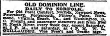
In the 19th and first half of the 20th centuries Old Point Comfort served as the terminus and connection point for passenger and express freight ships connecting cities of Chesapeake Bay by both water and rail routes with Boston, New York and along the southeastern coast.[11][12] Rail lines, for example the New York, Philadelphia and Norfolk Railroad, provided rail car through ferry service from Old Point Comfort to Cape Charles on the Eastern Shore of Virginia for land route connections to points north.[11] The Zero Mile Post for the Chesapeake and Ohio Railway is also here, and represents the end of the line from which all main line distances were measured between Fort Monroe and Cincinnati. The station at Fort Monroe closed in 1939.[13]
For most of the 19th and 20th centuries, Old Point Comfort was a summer and winter resort in the town of Phoebus in Elizabeth City County; in 1952 the residents of both the town and county voted to be consolidated with the independent city of Hampton. Old Point Comfort is the location of historic Fort Monroe, The Chamberlin, and the Old Point Comfort Light.[14]
1900s
The pier that was used by government vessels as well as being a routine stopping point for commercial shipping lines was government owned. On November 12, 1959 the Army issued notice it was closing the pier and that it would be removed. On January 2, 1960 the Army announced the pier would be open only "at your own risk" to visitors from shore, including guest of the Chamberlin Hotel that overlooked the pier, but closed to boat traffic and travelers. Steamship travel had declined after World War II and the last line using the Old Point Comfort stop was the Baltimore Steam Packet Company operating as the Old Bay Line. The line's City of Richmond made the last stop at the pier December 30, 1959. Despite a court injunction based on the terms under which Virginia ceded the land to the Federal Government in 1821 the pier was destroyed after federal courts overruled the injunction. The pier was demolished by the end of May 1961.[15]
Old Point Comfort was the site in 1909 where Southern Baptists and Northern Baptists inaugurated negotiations toward a comity agreement.[16][17]
It was near Old Point Comfort that the USS Missouri (BB-63), then the only U.S. battleship in commission, was proceeding seaward on a training mission from Hampton Roads early on 17 January 1950 when she ran aground 1.6 miles (3.0 km) from Thimble Shoal Light (near Old Point Comfort). She hit shoal water a distance of three ship-lengths from the main channel. Lifted some seven feet above waterline, she stuck hard and fast. With the aid of tugboats, pontoons, and an incoming tide, she was refloated on 1 February 1950 and repaired.[18]
References
- "New Point Comfort". InterMarket Advertising. Retrieved 4 February 2011.
- "Virginia, A Guide to the Old Dominion, (1952), pg.483, By Federal Writers' Project
- Encyclopædia Britannica, 11th Edition, Search.com
- The Second Virginia Charter (May 23, 1609)
- Boundaries and Charters of Virginia. Accessed 2010.08.27.
- https://www.nationalgeographic.com/archaeology-and-history/magazine/2019/07-08/virginia-first-africans-transatlantic-slave-trade/, 400 years ago, enslaved Africans first arrived in Virginia
- https://time.com/5653369/august-1619-jamestown-history/, The First Africans in Virginia Landed in 1619. It Was a Turning Point for Slavery in American History—But Not the Beginning
- "Miles Cary". Virginia Humanities. Retrieved 2 August 2019.
- "Old Point Comfort, VA". LighthouseFriends.com. Retrieved 4 February 2011.
- Erickson, Mark St. John (22 October 2014). "Hampton Roads swooned over Lafayette's 1824 return as a Revolutionary War icon". Daily Press. Retrieved 6 March 2018.
- Allen, W.F. (1908). "Search results "Old Point Comfort"". Official Guide of the Railways and Steam Navigation Lines of the United States, Porto Rico, Canada, Mexico and Cuba. National Railway Publication Company. 40 (8). Retrieved 11 October 2014.
- Brooklyn Daily Eagle (1898). "Advertisements: Ocean Steamships". Brooklyn Daily Eagle. Brooklyn Daily Eagle (19 March 1898). Retrieved 11 October 2014.
- "The Zero Mile Post Historical Marker". www.hmdb.org. Retrieved 2019-10-07.
- Old Point Comfort Resort: Hospitality, Health and History on Virginia's Chesapeake Bay. By John V. Quarstein, Julie Steere Clevenger
- Brown, Alexander Crosby (1961). Steam Packets on the Chesapeake. Cambridge, Maryland: Tidewater Publishers. pp. 135–138. ISBN 0-87033-111-6. LCCN 61012580. Retrieved 29 August 2019.CS1 maint: ref=harv (link)
- "Southern Baptists Nationwide". Cooperative Program and the Annie Armstrong Easter Offering, North American Mission Board, SBC. Retrieved 4 February 2011.
- William H. Brackney, Baptists in North America: an historical perspective, (2006), p. 70
- "USS Missouri (BB-63), Grounding, January 1950", US Navy History, Accessed 2010.8.27.

External links
- Old Point Comfort lighthouse, Lighthouse Friends Website
- Miles Cary Profile, Encyclopedia Virginia
- Photo, overview of pier from Chamberlin Hotel roof with City of Norfolk arriving
- Photo, Old Bay Line's City of Richmond making last stop at Old Point Comfort pier
| Authority control |
|
|---|