Ohio State Route 568
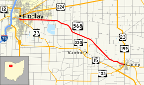
State Route 568 (SR 568) is an east–west state highway in the northwestern portion of the U.S. state of Ohio. The western terminus of this highway is at a signalized intersection in downtown Findlay where it meets State Route 12 and State Route 37. The eastern terminus of State Route 568 is in downtown Carey at a signalized intersection that serves as all of the northern split of the U.S. Route 23/State Route 103 concurrency, the western split of the State Route 103/State Route 199 concurrency and the southern split of the U.S. Route 23/State Route 199 concurrency.
| ||||
|---|---|---|---|---|
 | ||||
| Route information | ||||
| Maintained by ODOT | ||||
| Length | 16.20 mi[1] (26.07 km) | |||
| Existed | 1965[2][3]–present | |||
| Major junctions | ||||
| West end | ||||
| East end | ||||
| Location | ||||
| Counties | Hancock, Wyandot | |||
| Highway system | ||||
| ||||

State Route 568 was created in the middle of the 1960s. The entire length of this two-lane highway is part of the former alignment of State Route 15, which was realigned onto a new expressway from Findlay to Carey at that time.
Route description
Along its path, State Route 568 passes through eastern Hancock County and northwestern Wyandot County. There are no segments of State Route 568 that are incorporated within the National Highway System, a network of highways deemed most important for the economy, mobility and defense of the country.[4]
History
State Route 568 was established in 1965. With the completion of a new four-lane divided expressway from Interstate 75 south of Findlay and U.S. Route 23/State Route 103 south of Carey, the State Route 15 designation, which had utilized a two-lane roadway between downtown Findlay and downtown Carey to that point, was transferred onto the new expressway, which parallels the two-lane road to the south. Consequently, this two-lane highway became known as State Route 568. The route has utilized the same alignment from inception to this day, and has not seen any significant changes since its original designation.[2][3]
Prior to the presently designated Route 568, a previous Route 568 traversed northern Lucas County and Fulton County, Ohio. Established around 1939, it originally ran from the Ohio-Michigan line west of Lyons, Ohio to present-day U. S. 24 (N. Detroit and Alexis). However, within a year, the part west of old U.S. 223 (present day Monroe Street and Alexis Road in Sylvania) was renamed Route 120. Subsequently only the portion east of Monroe Street remained as Route 568, entirely encompassing Alexis Road. It was decommissioned as a state route before 1953. [5]
Major intersections
| County | Location | mi[1] | km | Destinations | Notes |
|---|---|---|---|---|---|
| Hancock | Findlay | 0.00 | 0.00 | Western end of SR 37 concurrency | |
| 0.14 | 0.23 | Eastern end of SR 37 concurrency | |||
| Biglick Township | 9.93 | 15.98 | Northern terminus of SR 330 | ||
| Wyandot | Carey | 16.20 | 26.07 | ||
1.000 mi = 1.609 km; 1.000 km = 0.621 mi
| |||||
References
- Ohio Department of Transportation. "Technical Services Straight Line Diagrams". Retrieved 2006-11-08.
- Official Ohio Highway Map (MrSID) (Map). Cartography by ODOH. Ohio Department of Highways. 1964. Retrieved 2011-01-17.
- Official Ohio Highway Map (MrSID) (Map). Cartography by ODOH. Ohio Department of Highways. 1965. Retrieved 2011-01-17.
- National Highway System: Ohio (PDF) (Map). Federal Highway Administration. December 2003. Retrieved 2011-01-17.
- U. S. G. S. Topographic Maps: 7.5' Quadrangles for Sylvania (1951) Toledo (1951). Also, Toledo 1:250,000 U. S. G. S. maps dated 1948, and Ohio Department of Transportation Maps dated 1939, 1940 and 1953.