Ohio State Route 283
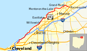
State Route 283 (SR 283) is an east–west state highway in the northeastern portion of the U.S. state of Ohio. Its western terminus at U.S. Route 6 2½ miles northeast of Downtown Cleveland, and its eastern terminus at U.S. Route 20 (Erie Street) in Painesville. Most of the route is known as Lake Shore Boulevard until it approaches the Grand River in Lake County. During its final stretch, its name changes to Olive Street, River Street, and finally to Richmond Street. The entire highway is part of the Lake Erie Circle Tour.
| |||||||
|---|---|---|---|---|---|---|---|
| Lake Shore Boulevard | |||||||
 | |||||||
| Route information | |||||||
| Maintained by ODOT | |||||||
| Length | 29.76 mi[1] (47.89 km) | ||||||
| Existed | 1932–present | ||||||
| Tourist routes | |||||||
| Major junctions | |||||||
| West end | |||||||
| |||||||
| East end | |||||||
| Location | |||||||
| Counties | Cuyahoga, Lake | ||||||
| Highway system | |||||||
| |||||||

Route description
History
- 1932 – Original route established; route east of current State Route 175 was State Route 175 before 1929, and was then the former State Route 6 from 1929 to 1932.[2]
- 1959 – 4 miles (6.4 km) east of Downtown Cleveland to 3 miles (4.8 km) west of Euclid upgraded to freeway and dually certified with State Route 2.[2]
- 1962 – Interstate 90 certification added to freeway portion 4 miles (6.4 km) east of Downtown Cleveland to 3 miles (4.8 km) west of Euclid.[2]
Major intersections
| County | Location | mi[1] | km | Destinations | Notes | |
|---|---|---|---|---|---|---|
| Cuyahoga | Cleveland | 0.00 | 0.00 | |||
| 1.84 | 2.96 | Exit 178 (I-90 / SR 2) | ||||
| 5.03 | 8.10 | Exit 179 (I-90 / SR 2) | ||||
| Euclid | 11.39 | 18.33 | Northern terminus of SR 175 | |||
| Lake | Willowick | 13.69 | 22.03 | Western terminus of SR 640 | ||
| Timberlake | 16.09 | 25.89 | Northern terminus of SR 91 | |||
| Mentor | 20.80 | 33.47 | Northern terminus of SR 306 | |||
| Mentor-on-the-Lake | 21.60 | 34.76 | Northern terminus of SR 615 | |||
| Mentor | 26.57 | 42.76 | Interchange | |||
| Painesville | 28.56 | 45.96 | Western terminus of SR 535 | |||
| 28.69 | 46.17 | Interchange | ||||
| 29.76 | 47.89 | |||||
1.000 mi = 1.609 km; 1.000 km = 0.621 mi
| ||||||
References
- Ohio Department of Transportation. "Technical Services Straight Line Diagrams". Retrieved April 30, 2010.
- Route 283 (The Unofficial Ohio State Highways Web Site) by John Simpson Archived January 7, 2005, at the Wayback Machine
This article is issued from Wikipedia. The text is licensed under Creative Commons - Attribution - Sharealike. Additional terms may apply for the media files.