Ohaeawai
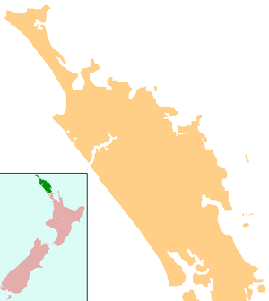
Ohaeawai (officially Ōhaeawai) is a small village at the junction of State Highway 1 and State Highway 12 in the Far North District of New Zealand, some 250 km (160 mi) from Auckland. The town of Kaikohe is 10.4 km (6.5 mi) to the west, and the Bay of Islands is a short drive to the east.
Ohaeawai | |
|---|---|
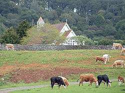 St Michael's Church sits atop the pa site today in a pastoral setting | |
 Ohaeawai | |
| Coordinates: 35°21′4″S 173°52′55″E | |
| Country | New Zealand |
| Region | Northland Region |
| District | Far North District |
| Population (2013) | |
| • Total | 429 |
The New Zealand Ministry for Culture and Heritage gives a translation of "place of thermal waters" for Ōhaeawai.[1]
History
Nearby is the site of the bloody Battle of Ohaeawai fought at Pene Taui's pā (fort) during the Flagstaff War in 1845. The therapeutic mercurial waters of the minor health spa of Ngawha Springs are in a small thermal area to the west, where Northland prison is situated. The village is the centre of a rich farming district as a result of the fertile volcanic soils, with the district known to the Ngāpuhi as Tai-a-mai.[2]
.jpg)
Taiamai was the name given to a large boulder of volcanic rock situated about 400 m (quarter mile) south east of the Ohaeawai Hotel. This prominent rock stands about 3.5 metres (11 ft) high, and was formerly an uruuru whenua, a place where travellers recited a charm and placed a small offering, such as a branch or tuft of grass, in order to placate the spirits of that place.[2]
In 1845 Te Ruki Kawiti and Pene Taui fortified Taui's pā (fort), which British forces laid siege to in July that year. The outcome of the Battle of Ohaeawai is considered to be a defeat of the British colonial forces. St. Michael's Anglican Church was built in 1870 on the site of the pā.[3]
St. Michael's Anglican Church is 7.2 km (4.5 mi) from Kaikohe and 3.2 km from the township of Ohaeawai, situated on a gentle rise a short distance west of the main road.[4] In August 2018 the battleground area around the church, including the urupa (cemetery), was added to the Heritage New Zealand list as a wāhi tapu, a place sacred to the Ngati Hine iwi and of historic significance.[5]
The locality is usually called Ngawha, from the hot springs in the neighbourhood. Cowan (1922) asserts that the site of the church (and earlier pā) is the true Ohaeawai and the European township which has appropriated the name should properly be known as Taiamai.[6]
Demographics
The population of the meshblocks immediately adjoining Ohaeawai was 429 in the 2018 census.[7]
| Historical population | ||
|---|---|---|
| Year | Pop. | ±% p.a. |
| 2006 | 864 | — |
| 2013 | 933 | +1.10% |
| 2018 | 1,140 | +4.09% |
| Source: [8] | ||
The statistical area of Ōhaeawai-Waimate North, which is much larger than the village at 87 square kilometres, had a population of 1,140 at the 2018 New Zealand census, an increase of 207 people (22.2%) since the 2013 census, and an increase of 276 people (31.9%) since the 2006 census. There were 408 households. There were 561 males and 579 females, giving a sex ratio of 0.97 males per female. Of the total population, 231 people (20.3%) were aged up to 15 years, 183 (16.1%) were 15 to 29, 501 (43.9%) were 30 to 64, and 225 (19.7%) were 65 or older. Figures may not add up to the total due to rounding.
Ethnicities were 71.8% European/Pākehā, 42.1% Māori, 2.9% Pacific peoples, 1.3% Asian, and 1.6% other ethnicities. People may identify with more than one ethnicity.
The percentage of people born overseas was 12.9, compared with 27.1% nationally.
Although some people objected to giving their religion, 51.8% had no religion, 36.3% were Christian, and 6.1% had other religions.
Of those at least 15 years old, 141 (15.5%) people had a bachelor or higher degree, and 186 (20.5%) people had no formal qualifications. The median income was $26,900. The employment status of those at least 15 was that 441 (48.5%) people were employed full-time, 144 (15.8%) were part-time, and 45 (5.0%) were unemployed.[8]
Marae
There are three Ngāpuhi marae in the Ohaeawai area. Parawhenua Marae is affiliated with the hapū of Ngāti Hineira, Ngāti Korohue, Te Uri Taniwha and Te Whanauwhero. Rāwhitiroa or Te Ahuahu Marae is affiliated with Ngāti Hineira, Te Kapotai, Te Popoto, Te Uri Taniwha and Ngawha Marae affiliated with Ngati Rangi. [9][10]
Education
Ohaeawai School is a coeducational contributing primary (years 1-6) school with a roll of 157 students.[11][12]
Notes
- "1000 Māori place names". New Zealand Ministry for Culture and Heritage. 6 August 2019.
- Best, Elsdon (1927). "Old Forts of the Taiamai District, Bay of Islands". The Pa Maori. Whitcombe and Tombs Limited.
- "New Zealand - Has the Work Died Out?". The Church Missionary Gleaner. 20: 115. 1870. Retrieved 1 December 2013.
- "St. Michael's, Ngawha". Don Donovan.
- Jenny Ling (August 2018). "Bloody battle site tapu". Northern News. Retrieved 8 August 2018.
- Cowan, James (1922). "Volume I: 1845–1864". The New Zealand Wars: a history of the Maori campaigns and the pioneering period. Wellington: R.E. Owen. pp. 73–144.
- "Meshblock Electoral Populations 2020 for proposed boundaries data". Statistics New Zealand. April 2020. Meshblocks 0034700, 0035200, 0035300 and 0036700.
- "Statistical area 1 dataset for 2018 Census". Statistics New Zealand. March 2020. Ōhaeawai-Waimate North (103200). 2018 Census place summary: Ōhaeawai-Waimate North
- "Te Kāhui Māngai directory". tkm.govt.nz. Te Puni Kōkiri.
- "Māori Maps". maorimaps.com. Te Potiki National Trust.
- "New Zealand Schools Directory". New Zealand Ministry of Education. Retrieved 26 April 2020.
- Education Counts: Ohaeawai School
External links
| Authority control |
|
|---|