North Carolina Highway 901
North Carolina Highway 901 (NC 901) is a primary state highway in the U.S. state of North Carolina. The highway serves to connect the town of Harmony with nearby major highways.
| ||||
|---|---|---|---|---|
| Memorial Highway | ||||
 | ||||
| Route information | ||||
| Maintained by NCDOT | ||||
| Length | 19.0 mi[1] (30.6 km) | |||
| Existed | 1930–present | |||
| Major junctions | ||||
| South end | ||||
| North end | ||||
| Location | ||||
| Counties | Davie, Iredell | |||
| Highway system | ||||
| ||||

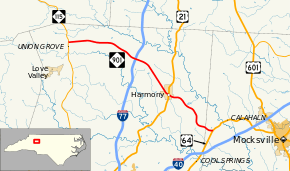
Route description
NC 901 is a two-lane rural highway that traverses 19.0 miles (30.6 km) from US 64, near Calahaln, to NC 115, near New Hope. Surrounded most of its journey with farmland, NC 901 is a no-thrills road through northern Iredell County.
NC 901 is a viable alternate route between Mocksville and Wilkesboro; it is shorter in mileage, though takes a few minutes longer than via US 601 and US 421.
History
Established by 1930 as a new primary routing, from US 64/NC 90 to US 21/NC 26, in Harmony. In 1937, NC 901 was extended northwest to its current northern terminus at NC 115.
Junction list
| County | Location | mi[1] | km | Destinations | Notes |
|---|---|---|---|---|---|
| Davie | | 0.0 | 0.0 | ||
| Iredell | Harmony | 6.4 | 10.3 | ||
| | 11.6 | 18.7 | |||
| | 19.0 | 30.6 | |||
| 1.000 mi = 1.609 km; 1.000 km = 0.621 mi | |||||
References
- Google (November 18, 2013). "North Carolina Highway 901" (Map). Google Maps. Google. Retrieved November 18, 2013.
External links

- NCRoads.com: N.C. 901
- North Carolina Highway Begins/Ends - NC 901
This article is issued from Wikipedia. The text is licensed under Creative Commons - Attribution - Sharealike. Additional terms may apply for the media files.