North Carolina Highway 274
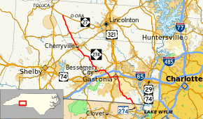
North Carolina Highway 274 (NC 274) is a primary state highway in the U.S. state of North Carolina. It connects rural areas of Lincoln and Gaston counties to Gastonia.
| ||||
|---|---|---|---|---|
 | ||||
| Route information | ||||
| Maintained by NCDOT | ||||
| Length | 36.7 mi[1] (59.1 km) | |||
| Existed | 1930–present | |||
| Major junctions | ||||
| South end | ||||
| North end | ||||
| Location | ||||
| Counties | Gaston, Lincoln | |||
| Highway system | ||||
| ||||

Route description
History
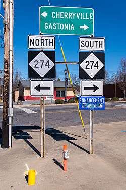
NC 274 was established in 1930 as a new primary routing, from NC 27 to U.S. Route 74 (US 74) and NC 20 (now NC 161) in Bessemer City.[2] Around 1938, it was extended southeast to its current southern terminus at the South Carolina state line, where it continues as South Carolina Highway 274 (SC 274).[3] Between 1963 and 1968, southbound lanes along Broad Street were added on west side of tracks in downtown Gastonia.
Junction list
| County | Location | mi[1] | km | Destinations | Notes |
|---|---|---|---|---|---|
| Gaston | | 0.0 | 0.0 | South Carolina state line | |
| Gastonia | 10.3 | 16.6 | North end of US 29 and east end of US 74 overlap | ||
| 10.7 | 17.2 | North-south US 321 divided on one-way streets | |||
| 12.4 | 20.0 | South end of US 29 and west end of US 74 overlap | |||
| 13.9 | 22.4 | ||||
| 15.0 | 24.1 | ||||
| Bessemer City | 17.6 | 28.3 | |||
| | 23.3 | 37.5 | |||
| Cherryville | 26.6 | 42.8 | |||
| Lincoln | | 31.0 | 49.9 | ||
| Hulls Crossroads | 36.7 | 59.1 | |||
1.000 mi = 1.609 km; 1.000 km = 0.621 mi
| |||||
References
- Google (January 8, 2012). "North Carolina Highway 274" (Map). Google Maps. Google. Retrieved January 8, 2012.
- State Highway System of North Carolina (PDF) (Map). Cartography by NCDOT. North Carolina Department of Transportation. 1930. Retrieved November 10, 2014.
- North Carolina Primary Highway System (PDF) (Map). Cartography by NCDOT. North Carolina Department of Transportation. 1940. Retrieved November 10, 2014.
External links

- NCRoads.com: N.C. 274
This article is issued from Wikipedia. The text is licensed under Creative Commons - Attribution - Sharealike. Additional terms may apply for the media files.