North Battleford Airport
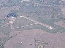
North Battleford Airport, (IATA: YQW, ICAO: CYQW), is located 1.5 nautical miles (2.8 km; 1.7 mi) east of North Battleford, Saskatchewan, Canada.
North Battleford Airport | |||||||||||||||
|---|---|---|---|---|---|---|---|---|---|---|---|---|---|---|---|
 North Battleford Airport | |||||||||||||||
| Summary | |||||||||||||||
| Airport type | Public | ||||||||||||||
| Operator | City of North Battleford | ||||||||||||||
| Location | North Battleford, Saskatchewan | ||||||||||||||
| Time zone | CST (UTC−06:00) | ||||||||||||||
| Elevation AMSL | 1,799 ft / 548 m | ||||||||||||||
| Coordinates | 52°46′09″N 108°14′40″W | ||||||||||||||
| Map | |||||||||||||||
 CYQW Location in Saskatchewan  CYQW CYQW (Canada) | |||||||||||||||
| Runways | |||||||||||||||
| |||||||||||||||
| Statistics (2006) | |||||||||||||||
| |||||||||||||||
History
World War II
It was built during World War II as part of the British Commonwealth Air Training Plan and known as RCAF Station North Battleford. The station hosted the Royal Air Force's No. 35 Service Flying Training School RAF from 4 September 1941 to 25 February 1944, and then No. 13 Service Flying Training School RCAF until 30 March 1945. Relief airfields were located at Brada and Hamlin.[4]
Aerodrome Information
In approximately 1942 the aerodrome was listed as RCAF & D of T Aerodrome - North Battleford at 52°46′N 108°16′W with a variation of 22 degrees east and elevation of 1,787 ft (545 m). Six runways were listed as follows: [5]
| Runway Name | Length | Width | Surface |
|---|---|---|---|
| 16/34 | 2,700 ft (820 m) | 100 ft (30 m) | Hard surfaced |
| 16/34 | 2,700 ft (820 m) | 100 ft (30 m) | Hard surfaced |
| 12/30 | 2,700 ft (820 m) | 100 ft (30 m) | Hard surfaced |
| 12/30 | 3,000 ft (910 m) | 100 ft (30 m) | Hard surfaced |
| 6/24 | 2,900 ft (880 m) | 100 ft (30 m) | Hard surfaced |
| 6/24 | 2,700 ft (820 m) | 100 ft (30 m) | Hard surfaced |
Relief landing field – Brada
A Relief Landing field for RCAF Station North Battleford was located approximately 7 mi (11 km) south-east. The site was located east of the community of Brada, Saskatchewan. The Relief field was constructed in the typical triangular pattern. In approximately 1942 the aerodrome was listed as RCAF Aerodrome - Brada, Saskatchewan at 52°43′N 108°07′W with a variation of 21 degrees 30' east and elevation of 1,830 ft (560 m). Though listed as a turf all way field, three runways were listed as follows [6]
| Runway Name | Length | Width | Surface |
|---|---|---|---|
| 16/34 | 3,300 ft (1,000 m) | ---' | Turf |
| 10/28 | 3,300 ft (1,000 m) | ---' | Turf |
| 4/22 | 3,300 ft (1,000 m) | ---' | Turf |
A review of Google Maps on 7 June 2018 shows no visibility of the airfield at the listed coordinates.
Postwar (1945-2010)
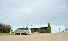
Postwar it became known as North Battleford (Cameron McIntosh) after Cameron Ross McIntosh. It was transferred from Transport Canada to the City of North Battleford on January 1, 1997.[7] In April 2010 a contract was awarded for renovations to the air terminal building.[8]
Present (2010- )
The North Battleford Gliding Centre, a Royal Canadian Air Cadets gliding centre, stores its gliders outside in permanent tie downs, and has office space in a trailer. The gliding centre conducts winch and air-tow operations in both the spring and the fall. The gliding centre currently operates two gliders, Number 2 (C-GCLS) and Number 10 (C-GRFQ); one winch, and one Bellanca Scout Towplane #5 (C-GBAZ).
References
- Canada Flight Supplement. Effective 0901Z 30 January 2020 to 0901Z 26 March 2020.
- Synoptic/Metstat Station Information
- Total aircraft movements by class of operation
- Hatch, F. J. (1983). The Aerodrome of Democracy: Canada and the British Commonwealth Air Training Plan, 1939-1945. Ottawa: Directorate of History, Department of National Defence. ISBN 0660114437.
- Staff writer (c. 1942). Pilots Handbook of Aerodromes and Seaplane Bases Vol. 2. Royal Canadian Air Force. p. 54.
- Staff writer (c. 1942). Pilots Handbook of Aerodromes and Seaplane Bases Vol. 2. Royal Canadian Air Force. p. 67.
- City transportation infrastructure
- Archived April 30, 2010, at the Wayback Machine
External links
- Page about this airport on COPA's Places to Fly airport directory
- Past three hours METARs, SPECI and current TAFs for North Battleford Airport from Nav Canada as available.
| By name | |
|---|---|
| By location indicator | |
| By province/territory | |
| By area | |
| National Airports System | |
| Related | |
| |