Noirmoutier
Noirmoutier (also in French: Île de Noirmoutier) is a tidal island off the Atlantic coast of France in the Vendée department.
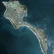 Noirmoutier Island image from satellite Spot | |
 Noirmoutier | |
| Geography | |
|---|---|
| Location | Atlantic Ocean |
| Coordinates | 46°58′N 2°13′W |
| Area | 49 km2 (19 sq mi) |
| Length | 19 km (11.8 mi) |
| Width | 6 km (3.7 mi) |
| Highest elevation | 20 m (70 ft) |
| Highest point | No named |
| Administration | |
France | |
| Region | Pays de la Loire |
| Department | Vendée |
| Arrondissement | Les Sables-d'Olonne |
| Demographics | |
| Population | 9,590 |
| Pop. density | 195.76/km2 (507.02/sq mi) |
| Ethnic groups | French people |
| Official name | Marais Breton, Baie de Bourgneuf, Ile de Noirmoutier et Forêt de Monts |
| Designated | 2 February 2017 |
| Reference no. | 2283[1] |
History
Noirmoutier was the location of an early Viking raid in 799, when raiders attacked the monastery of Saint Philibert of Jumièges in 799.[2]
St. Mary Euphrasia Pelletier was born on this island on July 31, 1796.
Geography
The island comprises ten localities and four distinct Communes of France. Its length is approximately 25 kilometres (16 mi), and its width varies from 500 metres (1,600 ft) to 15 kilometres (9.3 mi). Its area of 4,877 hectares (12,050 acres; 48.77 km2; 18.83 sq mi).
Noirmoutier is referred to as the Island of Mimosas, due to the temperateness of its climate, which allows for the flowering of Acacia dealbata (mimosa) year-round. The island is predominantly salt marsh and salt banks, sand dunes and evergreen oak forests.
The communes of the island are grouped into a communauté de communes. The communes are:
The island has been a site of uninterrupted human inhabitation since prehistoric times, and is a popular tourist destination.
Parts of the island have been reclaimed from the sea. In 2005 it served as the finish of the Tour de France prologue.
Transport
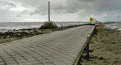
Noirmoutier has been connected to mainland France by bridge since 1971. The island is most notable for the Passage du Gois, a paved-over sandbank with a length of 4.5 kilometres (2.8 mi), one of the routes that connect the island to the mainland. It is flooded twice a day by the high tide.
Events
Every year, a foot race; the Foulées du Gois, is held across it, starting at the onset of the high tide.
Infrastructure
In response to an effort by the French government to add offshore wind projects to the national grid, a 496 MW wind farm is being developed near the island, with a planned commissioning date of 2021.[3]
Climate
Noirmoutier experiences an oceanic climate typical of the west coast of France. Both the winters and summers are heavily moderated by the surrounding Atlantic Ocean. There is a low degree of diurnal temperature variation throughout the year, especially in the winter. There is considerably more precipitation in winter compared to summer.
| Climate data for Noirmoutier Island, Vendée | |||||||||||||
|---|---|---|---|---|---|---|---|---|---|---|---|---|---|
| Month | Jan | Feb | Mar | Apr | May | Jun | Jul | Aug | Sep | Oct | Nov | Dec | Year |
| Record high °C (°F) | 16.9 (62.4) |
17.5 (63.5) |
22.9 (73.2) |
27.5 (81.5) |
31.3 (88.3) |
36.0 (96.8) |
37.0 (98.6) |
37.0 (98.6) |
33.0 (91.4) |
27.1 (80.8) |
20.5 (68.9) |
16.1 (61.0) |
37.0 (98.6) |
| Average high °C (°F) | 9.3 (48.7) |
9.8 (49.6) |
12.5 (54.5) |
14.9 (58.8) |
18.4 (65.1) |
21.5 (70.7) |
23.4 (74.1) |
23.5 (74.3) |
21.4 (70.5) |
17.4 (63.3) |
12.9 (55.2) |
9.9 (49.8) |
16.2 (61.2) |
| Average low °C (°F) | 4.7 (40.5) |
4.5 (40.1) |
6.4 (43.5) |
8.0 (46.4) |
11.3 (52.3) |
13.9 (57.0) |
15.7 (60.3) |
15.8 (60.4) |
13.9 (57.0) |
11.5 (52.7) |
7.7 (45.9) |
5.2 (41.4) |
9.9 (49.8) |
| Record low °C (°F) | −10.0 (14.0) |
−7.7 (18.1) |
−6.0 (21.2) |
0.0 (32.0) |
0.5 (32.9) |
6.0 (42.8) |
10.4 (50.7) |
9.5 (49.1) |
7.0 (44.6) |
1.7 (35.1) |
−4.0 (24.8) |
−8.0 (17.6) |
−10.0 (14.0) |
| Average precipitation mm (inches) | 70.1 (2.76) |
56.6 (2.23) |
49.4 (1.94) |
52.1 (2.05) |
52.2 (2.06) |
34.2 (1.35) |
38.6 (1.52) |
31.5 (1.24) |
56.9 (2.24) |
85.2 (3.35) |
80.9 (3.19) |
78.4 (3.09) |
686.1 (27.02) |
| Average precipitation days | 12 | 10 | 10 | 10 | 9 | 7 | 6 | 6 | 9 | 12 | 12 | 13 | 116 |
| Mean monthly sunshine hours | 87 | 136 | 182 | 226 | 255 | 291 | 274 | 259 | 233 | 149 | 107 | 112 | 2,311 |
| Source: Météo France - Period 1981-2010 - Extremes since 1959. | |||||||||||||
References
- "Marais Breton, Baie de Bourgneuf, Ile de Noirmoutier et Forêt de Monts". Ramsar Sites Information Service. Retrieved 25 April 2018.
- Sawyer, Peter. "The Viking Expansion." The Cambridge History of Scandinavia, Volume 1: Prehistory to 1520. 105.
- "496MW French Offshore Wind Farm Gets New Layout". Offshore Wind. Retrieved 1 August 2016.
External links
| Wikimedia Commons has media related to Île de Noirmoutier. |
| Authority control |
|
|---|