New York State Route 102
New York State Route 102 (NY 102) is an east–west state highway in Nassau County, New York, in the United States. It is little more than an alternate route of NY 24 through the town of Hempstead. NY 102 goes under the Meadowbrook State Parkway, but has no connecting ramps to or from the parkway. It does, however have a right-of-way for a formerly proposed eastbound lane. The route begins at an intersection with William Street in Hempstead before ending at NY 24 in East Meadow.
| ||||
|---|---|---|---|---|
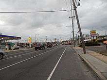
| Front Street | ||||
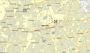 Map of Nassau County on Long Island with NY 102 highlighted red | ||||
| Route information | ||||
| Maintained by NYSDOT and Nassau County | ||||
| Length | 2.11 mi[1] (3.40 km) | |||
| Existed | c. 1932[2][3]–present | |||
| Major junctions | ||||
| West end | William Street in Hempstead | |||
| East end | ||||
| Location | ||||
| Counties | Nassau | |||
| Highway system | ||||
| ||||

NY 102 was assigned in the 1930s and has not been changed significantly since. Until 2017, NY 102 left NY 24 in West Hempstead and followed Front Street through the village of Hempstead and Uniondale before rejoining NY 24 in East Meadow. The portion of NY 102 west of William Street was maintained by Nassau County as County Route 106 and was unsigned while the remainder of the highway is maintained by the New York State Department of Transportation and signed.
Route description
NY 102 begins at an intersection with William Street in the village of Hempstead. The route winds eastward through Hempstead for several blocks along the now four-lane road, passing numerous residences and apartment buildings. NY 102 bends northeast, intersecting with Uniondale Avenue in Uniondale. At this junction, the route becomes commercial in nature once again, crossing several blocks of businesses until Locust Avenue. Now two lanes, NY 102 continues northeast through Uniondale, crossing under the six lanes of the Meadowbrook State Parkway (with no interchange present). After the Meadowbrook, the route continues to bend northeast, passing through more residences and large commercial strips. A short distance later, the route intersects with Merrick Avenue, entering the Barnum Woods section of East Meadow.[4]

In Barnum Woods, NY 102 becomes a mix of residential and commercial as the two-lane main street. At the junction with Vincent Road, NY 102 leaves Barnum Woods and enters East Meadow.The route remains commercial and residential in nature, proceeding northeast past a long strip mall near East Meadow Avenue. After passing a large complex of stores, NY 102 intersects with NY 24 (Hempstead Turnpike) once again in East Meadow. This T-intersection serves as the eastern terminus of NY 102, whose right-of-way also ends.[4]
History
The state-maintained section of NY 102 was improved to state highway standards as part of a project contracted out by the state of New York on September 20, 1907. A total of 7.09 miles (11.41 km) of highway were rebuilt as part of the $81,000 project (equivalent to $2.3 million in 2020), including all of modern NY 105. The reconstructed roads were added to the state highway system on November 2, 1908, as unsigned State Highway 437 (SH 437).[5][6] Both parts of SH 437 received posted route numbers in the early 1930s, with the Front Street segment becoming part of NY 102 c. 1932. The route also continued west over locally maintained roads in order to connect to NY 24 at both ends. NY 102's alignment has not been altered since.[2][3]
By 2017, NY 102's county-maintained section between NY 24 and William Street in the village of Hempstead was decommissioned, leaving only the state-maintained section east of the intersection.[7][8]
Major intersections
The entire route is in Nassau County.
| Location | mi[1] | km | Destinations | Notes | |
|---|---|---|---|---|---|
| West Hempstead–Hempstead line | 0.00 | 0.00 | Western terminus of CR 106 | ||
| Village of Hempstead | Greenwich Street (CR 7B south) | ||||
| Washington Street (CR 7A) | |||||
| Clinton Street (CR 1) / Peninsula Boulevard (CR 2) | |||||
| 0.00 | 0.00 | William Street | Route transition between CR 106 and NY 102; western terminus of NY 102 | ||
| Uniondale | Uniondale Avenue (CR 188) | ||||
| East Meadow | Merrick Avenue (CR 4) | ||||
| 2.11 | 3.40 | Eastern terminus of NY 102 | |||
1.000 mi = 1.609 km; 1.000 km = 0.621 mi
| |||||
References
- "2012 Traffic Data Report for New York State" (PDF). New York State Department of Transportation. July 12, 2013. p. 177. Retrieved July 22, 2014.
- New York (Map). Cartography by H.M. Gousha Company. Kendall Refining Company. 1931.
- Texaco Road Map – New York (Map). Cartography by Rand McNally and Company. Texas Oil Company. 1932.
- Microsoft; Nokia (June 15, 2012). "overview map of NY 102" (Map). Bing Maps. Microsoft. Retrieved June 15, 2012.
- State of New York Commission of Highways (1922). Tables Giving Detailed Information and Present Status of All State, County and Federal Aid Highways. Albany, NY: J. B. Lyon Company. p. 26. Retrieved December 28, 2012.
- Federal Reserve Bank of Minneapolis. "Consumer Price Index (estimate) 1800–". Retrieved January 1, 2020.
- "Nassau County Inventory Listing" (CSV). New York State Department of Transportation. February 28, 2012. Retrieved December 28, 2012.
- New York State Department of Transportation (January 2017). Official Description of Highway Touring Routes, Bicycling Touring Routes, Scenic Byways, & Commemorative/Memorial Designations in New York State (PDF). Retrieved January 15, 2017.
External links
| Wikimedia Commons has media related to New York State Route 102. |
- New York State Route 102 at New York Routes