New Mexico State Road 162
State Road 162 (NM 162) is a 2.6-mile-long (4.2 km) state highway in the US state of New Mexico. NM 162's southern terminus is at U.S. Route 84 (US 84) west-southwest of Tierra Amarilla in Rio Arriba County, and the northern terminus is at US 64/US 84 north of Tierra Amarilla. It is a paved, two-lane road for its entire length.
| ||||
|---|---|---|---|---|
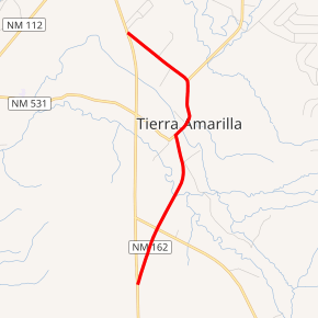
NM 162 highlighted in red | ||||
| Route information | ||||
| Maintained by NMDOT | ||||
| Length | 2.600 mi[1] (4.184 km) | |||
| Existed | 1950s–present | |||
| Major junctions | ||||
| South end | ||||
| North end | ||||
| Location | ||||
| Counties | Rio Arriba | |||
| Highway system | ||||
| ||||

Route description
NM 162 begins at a junction with US 84 near the Rio Chama State Recreation Area in unincorporated Rio Arriba County. The highway travels northeast and passes an electrical substation before an intersection with US 64 on the south side of the Rio de Tierra Amarilla, which it crosses before entering the community of Tierra Amarilla. At the county courthouse, NM 162 intersects NM 531 and turns northeast. In the northern outskirts of Tierra Amarilla, the highway intersects NM 573 and turns northwest, terminating at a junction with the concurrent US 64 and US 84.[2]
History
NM 162 was created in the 1950s, after US 84 was moved onto a new alignment west of Tierra Amarilla. NM 162 originally turned in Tierra Amarilla and followed the current NM 573 north to the current NM 512. It then turned west and followed the current NM 512 west towards US 64 and US 84 north of Brazos. In the 1988 renumbering, NM 512 and NM 573 were created and NM 162's northern terminus was changed to its current location.[3][4]
Major intersections
The entire route is in Rio Arriba County.
| Location | mi[5] | km | Destinations | Notes | |
|---|---|---|---|---|---|
| | 0.000 | 0.000 | Southern terminus | ||
| | 0.500 | 0.805 | |||
| Tierra Amarilla | 1.400 | 2.253 | Eastern terminus of NM 531 | ||
| 1.900 | 3.058 | Southern terminus of NM 573 | |||
| | 2.600 | 4.184 | Northern terminus | ||
| 1.000 mi = 1.609 km; 1.000 km = 0.621 mi | |||||
See also

References
- "Posted Route: Legal Description" (PDF). New Mexico Department of Transportation. March 16, 2010. p. 91. Retrieved October 25, 2018.
- Google (November 11, 2018). "State Road 162" (Map). Google Maps. Google. Retrieved November 11, 2018.
- Riner, Steve (January 19, 2008). "State Routes 151–175". New Mexico Highways. Retrieved November 16, 2018.
- 1964 USGS Topo Map
- "TIMS Road Segments by Posted Route/Point with AADT Info; NM, NMX-Routes" (PDF). New Mexico Department of Transportation. April 3, 2013. pp. 5–7. Retrieved October 20, 2018.