New Hampshire Route 124
New Hampshire Route 124 (abbreviated NH 124) is a 28.083-mile-long (45.195 km) east–west highway in southern New Hampshire, United States. It runs from Marlborough to the Massachusetts border.
| ||||
|---|---|---|---|---|
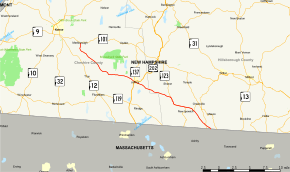 Map of southern New Hampshire with NH 124 highlighted in red | ||||
| Route information | ||||
| Maintained by NHDOT | ||||
| Length | 28.083 mi[1] (45.195 km) | |||
| Major junctions | ||||
| West end | ||||
| East end | Greenville Road in Townsend | |||
| Location | ||||
| Counties | Cheshire, Hillsborough | |||
| Highway system | ||||
| ||||

The western terminus of NH 124 is in Marlborough at New Hampshire Route 101. The road continues through Marlborough, a short section of Troy and enters the northwestern part of Jaffrey. The road skirts the southern slopes of Mount Monadnock, across Jaffrey, and into Sharon. In Sharon there is an historic marker on the northern side of the road marking the site of a gate that once collected tolls for the 3rd New Hampshire Turnpike, which followed much of the present-day route of NH 124. The road enters New Ipswich and continues through that town.
The eastern terminus of NH 124 is at the Massachusetts state line in Mason. The road continues into Massachusetts as Greenville Road in the town of Townsend.
Major intersections
| County | Location[1][2] | mi[1][2] | km | Destinations | Notes |
|---|---|---|---|---|---|
| Cheshire | Marlborough | 0.000 | 0.000 | Western terminus of NH 124 | |
| Jaffrey | 12.409 | 19.970 | Western end of concurrency with US 202 Southern terminus of NH 137 | ||
| 12.479 | 20.083 | Eastern end of concurrency with US 202 | |||
| Hillsborough | New Ipswich | 19.008 | 30.590 | Western end of concurrency with NH 123 | |
| 22.397 | 36.044 | Northern terminus of NH 123A (southern segment) | |||
| 23.915 | 38.487 | Eastern end of concurrency with NH 123 | |||
| Mason | 27.101 | 43.615 | |||
| 28.083 | 45.195 | Greenville Road – Townsend | Massachusetts–New Hampshire line | ||
1.000 mi = 1.609 km; 1.000 km = 0.621 mi
| |||||
References
- Bureau of Planning & Community Assistance (February 20, 2015). "NH Public Roads". Concord, New Hampshire: New Hampshire Department of Transportation. Retrieved April 7, 2015.
- Bureau of Planning & Community Assistance (April 3, 2015). "Nodal Reference 2015, State of New Hampshire". New Hampshire Department of Transportation. Retrieved April 7, 2015.
External links