New Bedford – Fairhaven Bridge
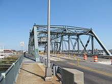
The New Bedford-Fairhaven Bridge is a swing truss bridge which connects New Bedford, Massachusetts with Fairhaven, Massachusetts.
New Bedford – Fairhaven Bridge | |
|---|---|
 New Bedford - Fairhaven Bridge | |
| Coordinates | 41.639158°N 70.917856°W |
| Carries | |
| Crosses | Acushnet River |
| Locale | New Bedford to Fairhaven, Massachusetts |
| Owner | MassDOT |
| NBI | F0100023PFDOTNBI |
| Characteristics | |
| Design | swing bridge |
| Material | steel |
| Total length | 283.2 feet (86.3 m)[1] |
| Width | 70.5 feet (21.5 m) (total width)[2] |
| Longest span | 142.1 feet (43.3 m)[2] |
| Load limit | 61.7 short tons (55.1 long tons; 56.0 t)[2] |
| Clearance above | 20.0 feet (6.1 m)[1] |
| Clearance below | 5.9 feet (1.8 m)[2] |
| History | |
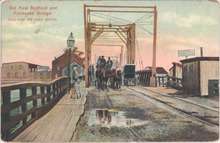
| Construction start | 1897 |
| Construction end | 1899 |
| Opened | 1900[2] |
| Rebuilt | 1997[2] |
| Statistics | |
| Daily traffic | 30,200 (2013)[2] |
 New Bedford – Fairhaven Bridge Location in Massachusetts | |
Between New Bedford and Fairhaven
The bridge is actually one of three bridges crossing the Acushnet River between the two communities. The entire four lane stretch carries U.S. Route 6 between the two communities. A short, 500-foot-long (150 m) span crosses between the mainland of New Bedford just west of McArthur Drive to Fish Island, the smaller western island in the river. From there, after a 0.1-mile stretch of highway connects the two spans, the main New Bedford-Fairhaven Bridge crosses from Fish Island to Pope's Island. This span includes the main span (see below). Once on Pope's Island, another 0.4-mile stretch of highway connects to the third and longest span, a low, 0.2-mile trestle bridge between Pope's Island and the town of Fairhaven, with the town line falling on the bridge. The entire stretch is just over one mile between the two shores.
The main span
While many maps include all three spans as one "New Bedford-Fairhaven Bridge", only the middle span between the two is the actual bridge. This span, which was built between 1897 and 1899, is the one which includes the 283.2-foot (86.3 m) swing truss across the main channel into the northern half of the harbor. The entire bridge, approaches included, is approximately 0.2 miles long, with the swing span being mostly west of the center of the bridge. The bridge still opens on a regular basis, with daily openings to allow the fishing fleet in and out of the inner harbor.
The bridge has been repaired numerous times in its lifetime, though there are occasional closings due to jammed gears. As of 2009, there are no plans to replace the 110-year-old span.
Major rehabilitation
As part of MassDOT's Accelerated Bridge Program, the New Bedford–Fairhaven Bridge and two other bridges will be rehabilitated. Work will include replacing joints and bearings, and cleaning, painting, and repairing steel, including repairing the existing granite piers and abutments. Construction is expected to begin in Spring 2011 and is expected to cost $24 million.[3]
See also


References
- Baughn, James. "New Bedford-Fairhaven Middle Bridge". Bridge Hunter. Retrieved 7 November 2016.
- "City Data". city-data.com. Retrieved 7 November 2016.
- search on MassDOT project ID 604329