Negro Hill
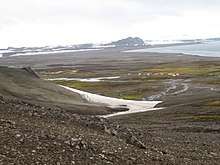
Negro Hill is a conspicuous rocky hill, double-peaked with a small tarn in between, rising to 143 m at South Beaches on Byers Peninsula, Livingston Island in the South Shetland Islands, Antarctica. It surmounts Fontus Lake on the south. The area was visited by 19th-century sealers.

The feature was descriptively named (‘Morro Negro’ meaning "Black Hill" in Spanish) by an Argentine Antarctic Expedition in about 1958.
Location
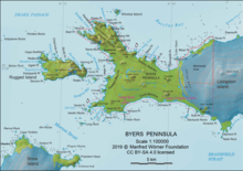
Negro Hill is located at 62°39′16.2″S 61°00′06″W, which is 1.1 km northeast of Dometa Point, 4.99 km east-northeast of Nikopol Point, 4.71 km east-southeast of Chester Cone, 1.95 km south of Tsamblak Hill and 4.04 km west-northwest of Rish Point (British mapping in 1968, detailed Spanish mapping in 1992, and Bulgarian mapping in 2005 and 2009).
Maps
- Península Byers, Isla Livingston. Mapa topográfico a escala 1:25000. Madrid: Servicio Geográfico del Ejército, 1992.
- L.L. Ivanov et al. Antarctica: Livingston Island and Greenwich Island, South Shetland Islands. Scale 1:100000 topographic map. Sofia: Antarctic Place-names Commission of Bulgaria, 2005.
- L.L. Ivanov. Antarctica: Livingston Island and Greenwich, Robert, Snow and Smith Islands. Scale 1:120000 topographic map. Troyan: Manfred Wörner Foundation, 2009. ISBN 978-954-92032-6-4